 Technical Report Summary on the
Tilden Property, Michigan, USA
S-K 1300 ReportCleveland-Cliffs Inc.
SLR Project No: 138.02467.00001
February 7, 2022
Effective Date: December 31, 2021
Technical Report Summary on the Tilden Property, Michigan, USA
SLR Project No: 138.02467.00001
Prepared by
SLR International Corporation
1658 Cole Blvd, Suite 100
Lakewood, CO 80401
for
Cleveland-Cliffs Inc.
200 Public Square, Suite 3300
Cleveland, OH 44114-2544
USA
Effective Date – December 31, 2021
Signature Date - February 7, 2022
Distribution: 1 copy – Cleveland-Cliffs Inc.
1 copy – SLR International Corporation
CONTENTS
| | | | | |
| |
| |
| |
| |
| |
| |
| |
| |
| |
| |
| |
3.3 Encumbrances | 28 |
3.4 Royalties | 28 |
3.5 Other Significant Factors and Risks | 28 |
| |
| |
| |
| |
| |
| |
| |
| |
| |
| |
| |
| |
| |
| |
| |
6.4 Deposit Types | 43 |
| |
| |
7.2 Geological Mapping | 50 |
7.3 Hydrogeology and Geotechnical Data | 50 |
| |

Cleveland-Cliffs Inc. | Tilden Property, SLR Project No: 138.02467.00001Technical Report Summary - February 7, 2022 i
| | | | | |
| |
| |
| 58 |
| |
| |
| |
| |
| |
| |
| |
| |
| |
| |
| |
| |
11.4 Resource Assays | 77 |
11.5 Compositing and Capping | 77 |
11.6 Trend Analysis | 81 |
11.7 Block Model | 84 |
11.8 Estimation Methodology | 84 |
11.9 Cut-off Grade | 86 |
11.10 Classification | 86 |
11.11 Model Validation | 89 |
11.12 Model Reconciliation | 94 |
11.13 Mineral Resource Statement | 95 |
| |
| 97 |
| |
| |
12.4 Mineral Reserve Cut-off Grade | 106 |
12.5 Mine Design | 106 |
| |
| |
| |
13.3 Open Pit Design | 115 |
13.4 Production Schedule | 122 |
13.5 Overburden and Waste Rock Stockpiles | 124 |
13.6 Mining Fleet | 127 |
Cleveland-Cliffs Inc. | Tilden Property, SLR Project No: 138.02467.00001Technical Report Summary - February 7, 2022 ii
| | | | | |
13.7 Mine Manpower | 128 |
| |
| |
| |
14.3 Pelletizing Plant | 132 |
14.4 Major Equipment | 134 |
14.5 Plant Performance | 135 |
14.6 Pellet Quality | 136 |
14.7 Consumable Requirements | 136 |
14.8 Process Workforce | 139 |
| |
| |
| |
| |
| |
| |
| |
| |
| |
| |
| |
| |
| |
| |
| |
| |
| |
| |
| |
| |
| 159 |
| |
| |
| |
| |
| |
Cleveland-Cliffs Inc. | Tilden Property, SLR Project No: 138.02467.00001Technical Report Summary - February 7, 2022 iii
TABLES
| | | | | |
| |
| |
| |
| |
| |
| |
| 16 |
| |
| |
| |
| |
| |
Table 6-1: Geometallurgical Groupings at Tilden | 42 |
| |
Cleveland-Cliffs Inc. | Tilden Property, SLR Project No: 138.02467.00001Technical Report Summary - February 7, 2022 iv
| | | | | |
| |
| |
| |
| 73 |
Table 11-2: Tilden Mine Mineral Resource Database | 77 |
Table 11-3: Tilden Mine Composite Statistics | 78 |
Table 11-4: Tilden Variogram Models | 83 |
Table 11-5: Summary of Block Model Setup | 84 |
Table 11-6: Search Strategy | 85 |
Table 11-7: Whittle Pit Parameters | 86 |
Table 11-8: Classification Criteria | 87 |
Table 11-9: 2021 Model Reconciliation | 94 |
Table 11-10: Summary of Mineral Resources – December 31, 2021 | 95 |
| |
| |
| |
| |
| |
Table 12-6: Pit Optimization to Pit Design Comparison | 106 |
| |
Table 13-2: Summary of UCS and BTS Test Results | 112 |
Table 13-3: Summary of Direct Shear Test Results | 112 |
Table 13-4: Material Properties Used in Overall Slope Stability Analysis | 113 |
Table 13-5: Anisotropic Material Properties Used in the Weak Direction | 114 |
Table 13-6: Final Pit Design LOM Total - December 31, 2021 | 115 |
Table 13-7: LOM Production Schedule | 123 |
Table 13-8: Stockpile Parameters | 125 |
Table 13-9: Volumes and Capacities of Stockpile Designs | 125 |
Table 13-10: Major Mining Equipment | 127 |
Table 14-1: Major Processing Equipment | 134 |
Table 14-2: Tilden Concentrator Performance 2014 to 2020 | 135 |
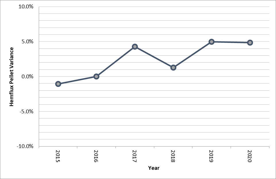
Table 14-3: Hemflux Pellet Quality | 136 |
Table 14-4: Consumables | 138 |
| |
| |
| |
| |
| |
| |
Cleveland-Cliffs Inc. | Tilden Property, SLR Project No: 138.02467.00001Technical Report Summary - February 7, 2022 v
FIGURES
| | | | | |
| |
| |
Figure 3-3: Surface Rights | 27 |
| |
| |
| |
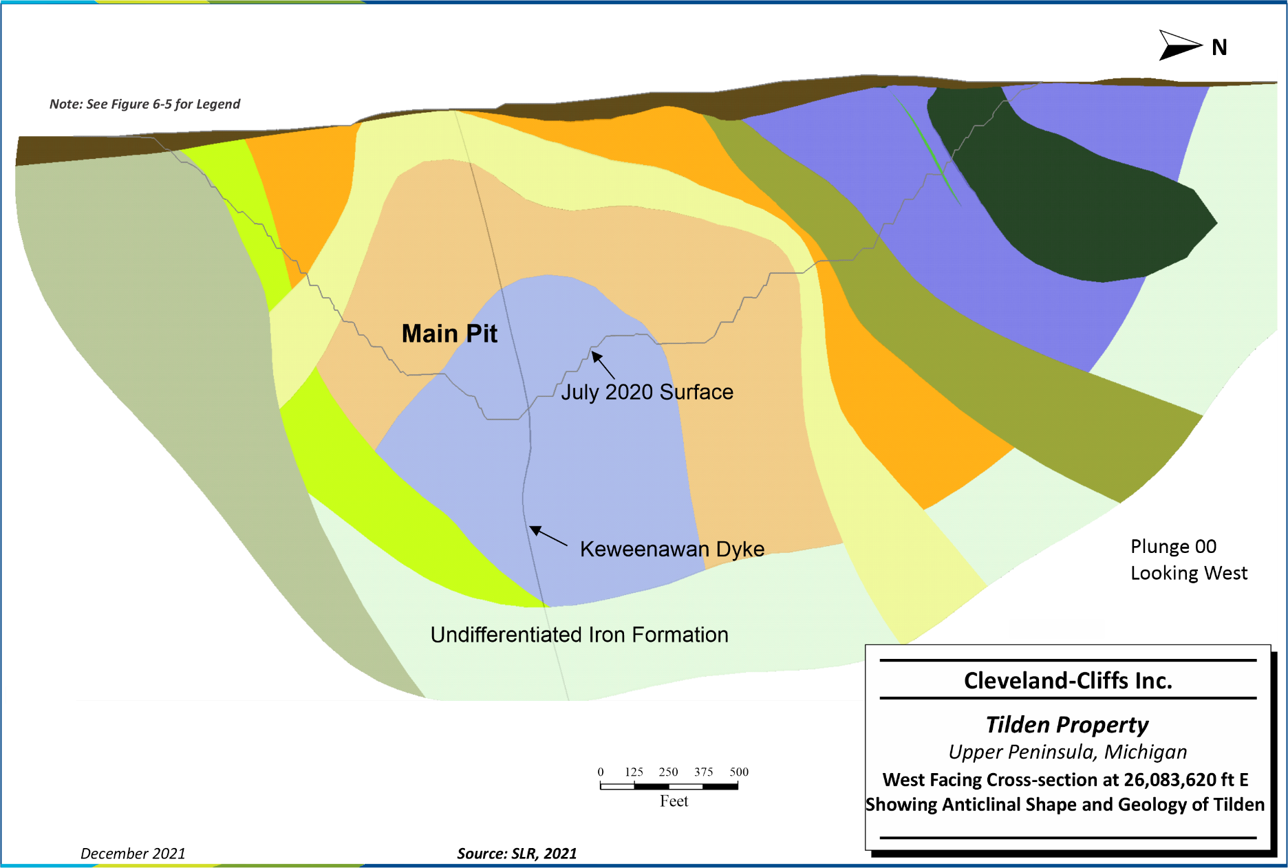
Figure 6-4: West-Facing Cross-section at 26,083,620 ft E Showing Anticlinal Shape and Geology of Tilden | 40 |
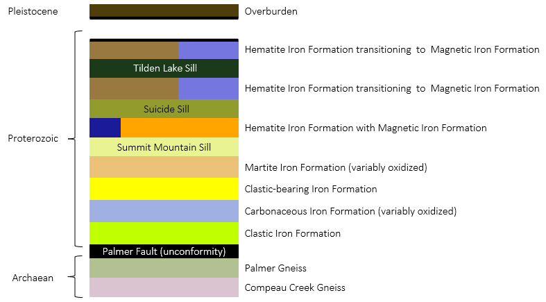
Figure 6-5: Basic Stratigraphic Section Local to Tilden | 41 |
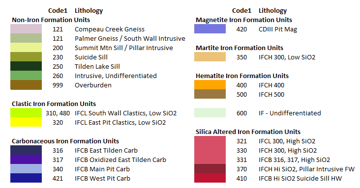
Figure 6-6: Selected Geometallurgical (code1) Groupings and Sub-groupings at Tilden | 43 |
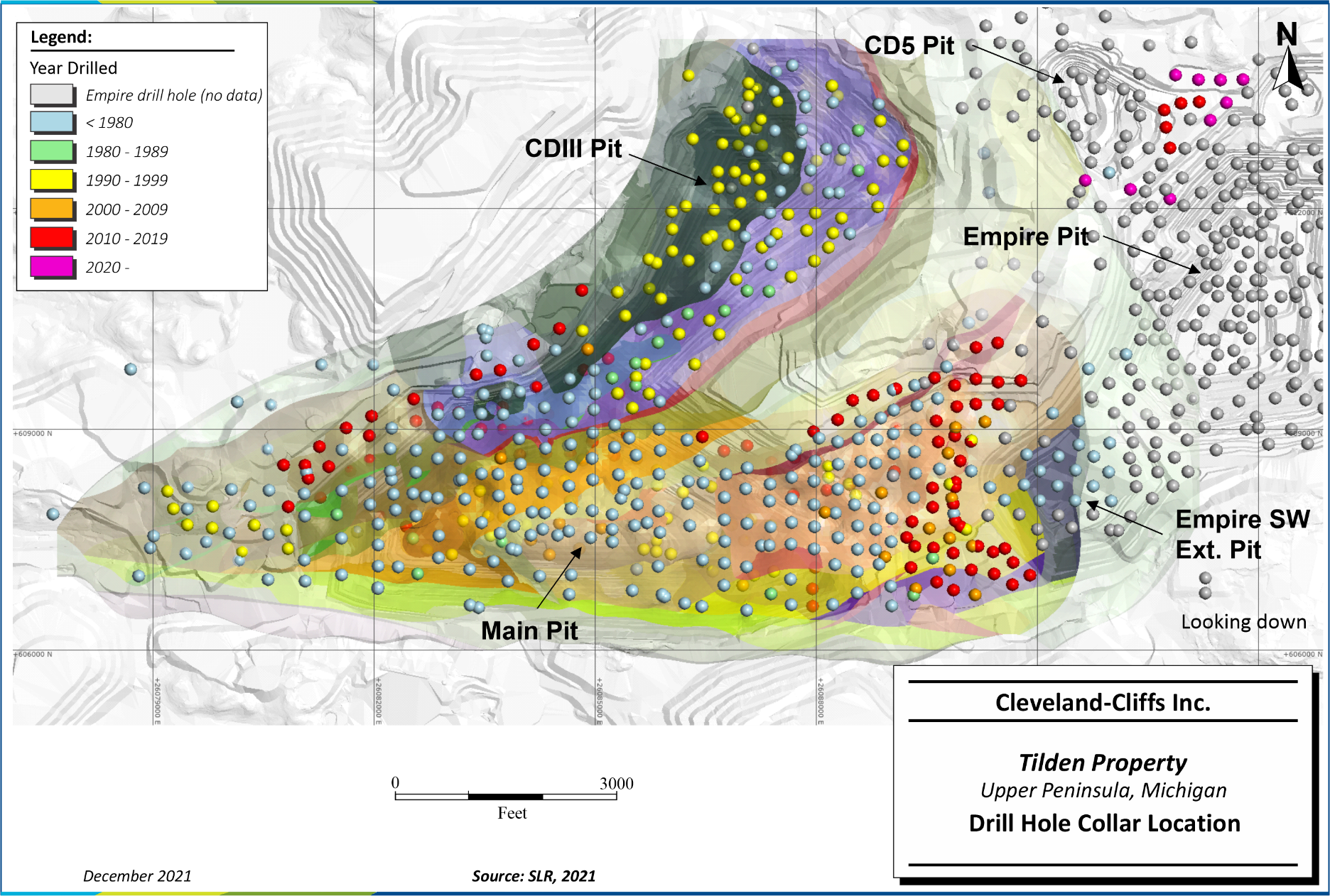
Figure 7-1: Drill Hole Collar Location | 47 |
| |
| |
| |
| |
| |
| |
| |
| |
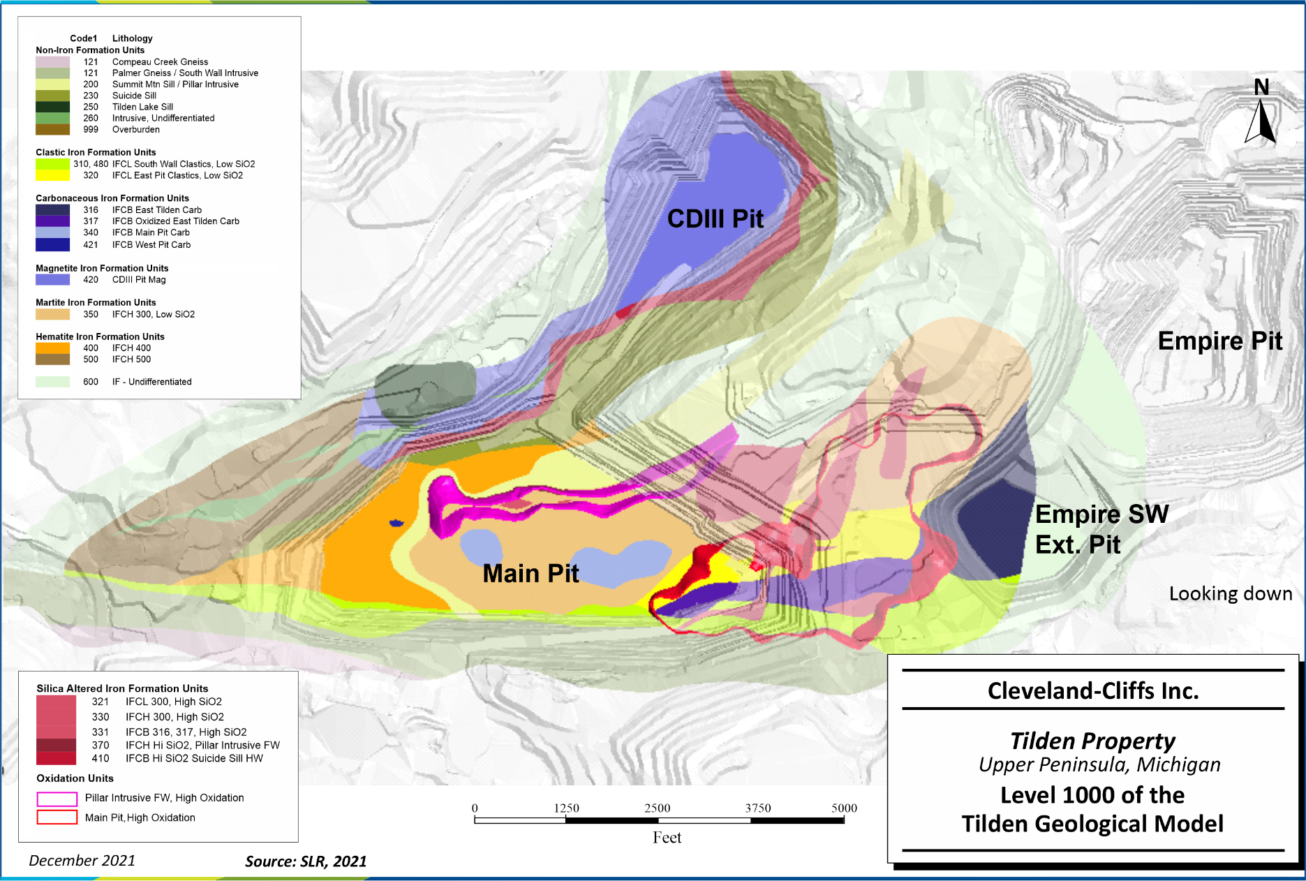
Figure 11-1: Level 1000 of the Tilden Geological Model | 75 |
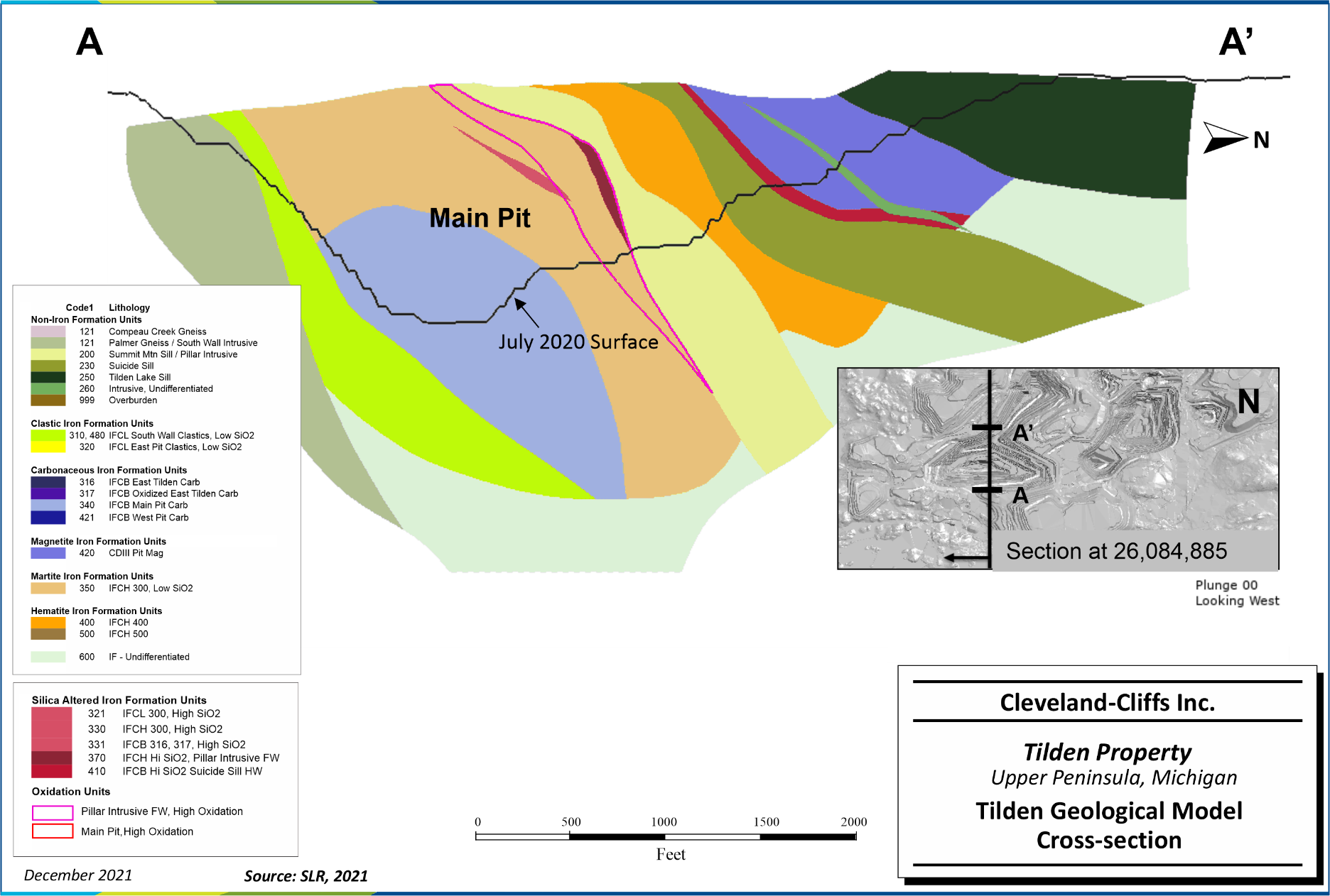
Figure 11-2: Tilden Geological Model Cross-section | 76 |
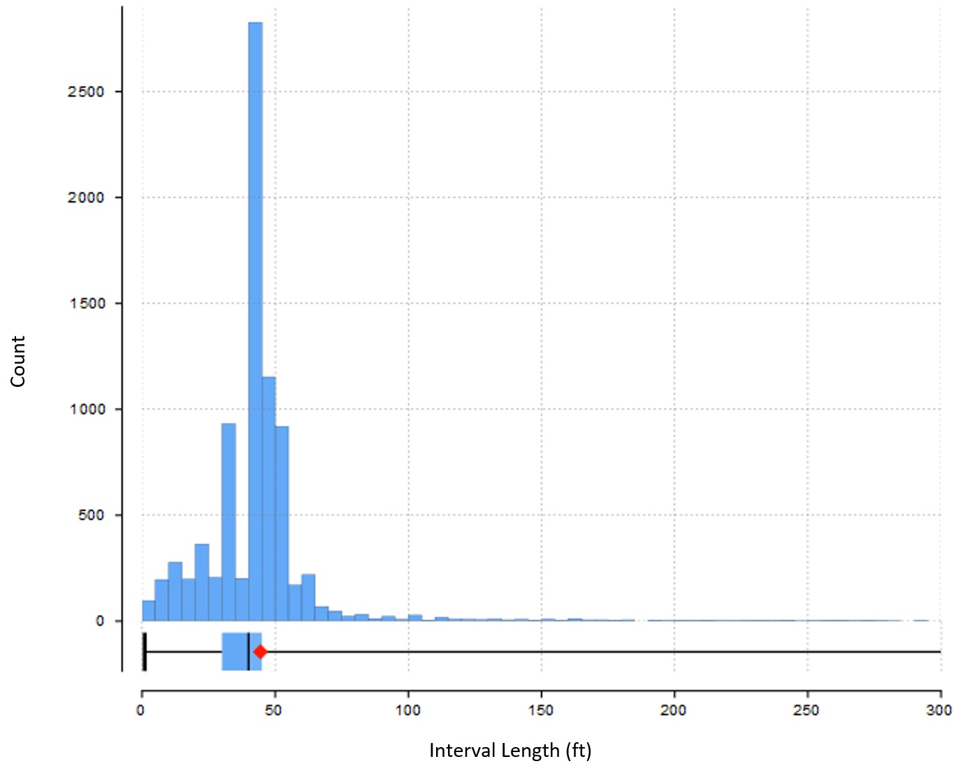
Figure 11-3: Histogram of Sample Length | 78 |
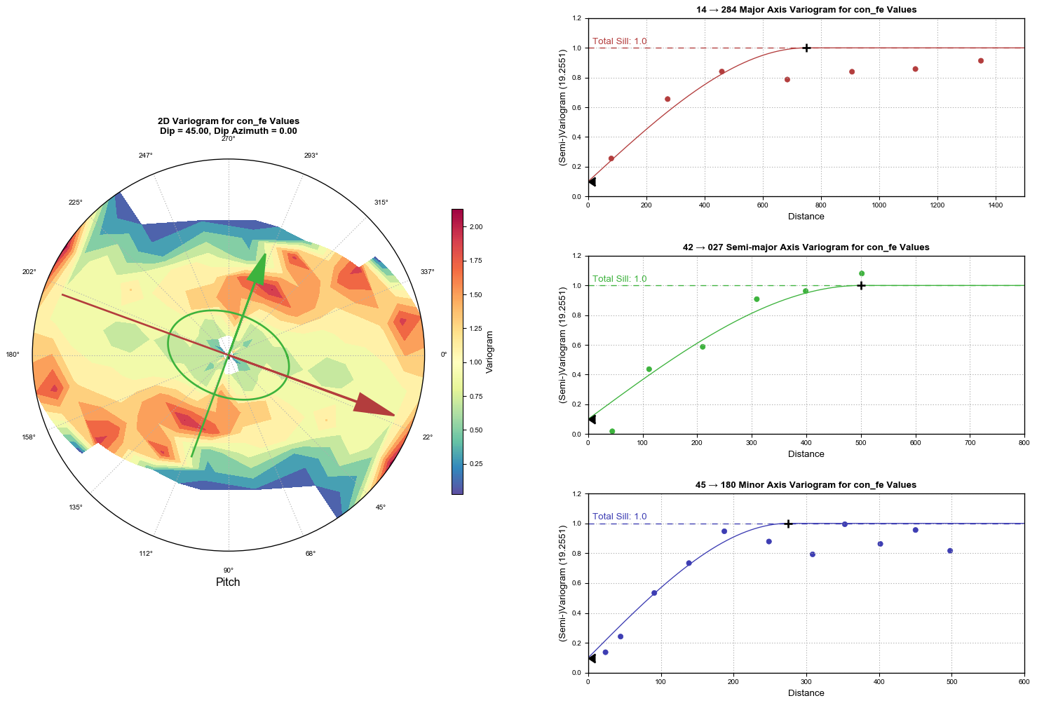
Figure 11-4: Radial Plot, Experimental Variogram and Model for confe Within IFCB Main Pit Carb (340) | 82 |
Cleveland-Cliffs Inc. | Tilden Property, SLR Project No: 138.02467.00001Technical Report Summary - February 7, 2022 vi
| | | | | |
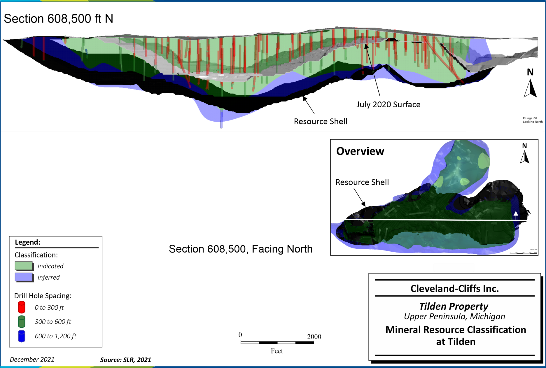
Figure 11-5: Mineral Resource Classification | 88 |
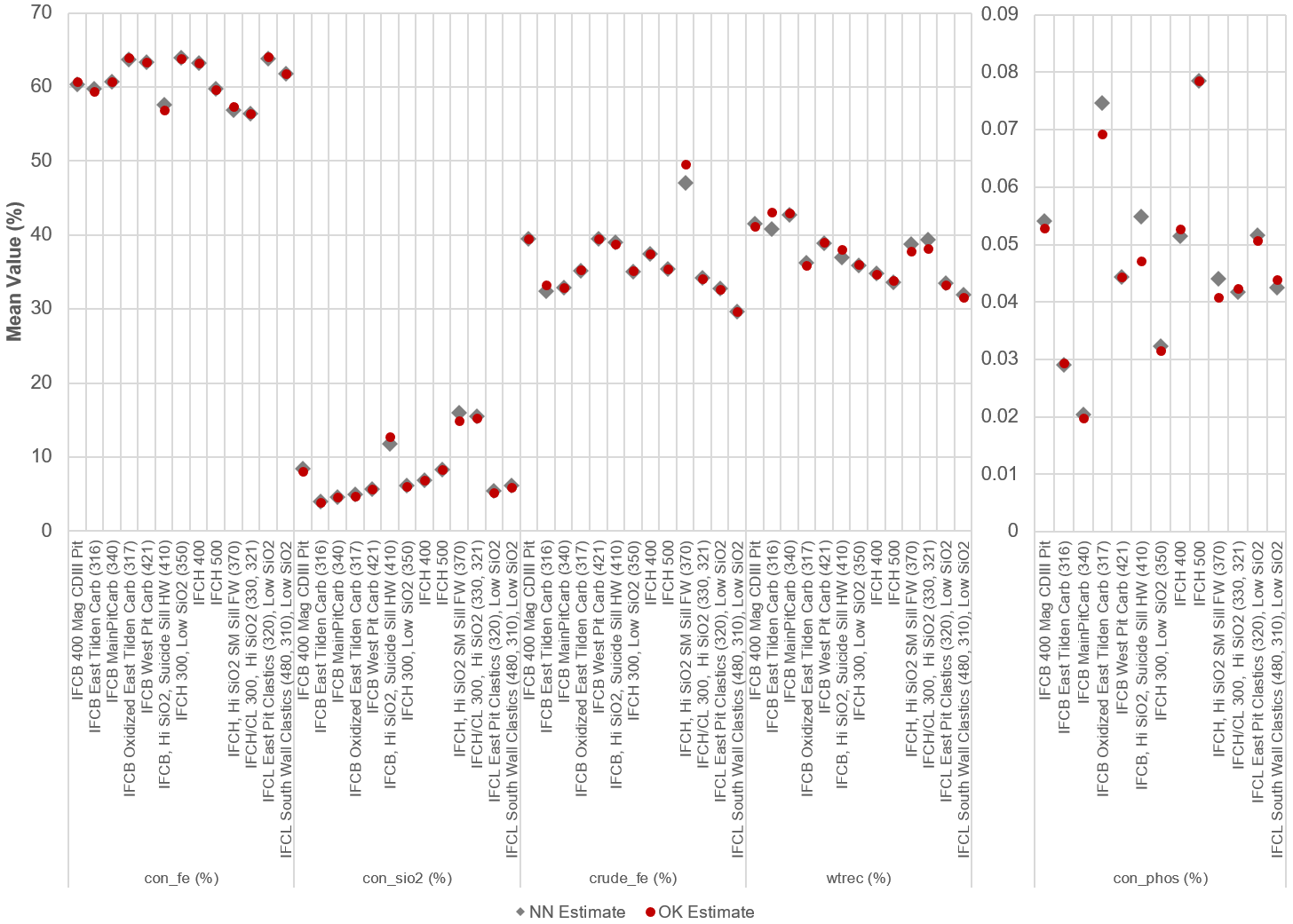
Figure 11-6: Comparison of OK and NN Estimates by Variable and Domain | 90 |
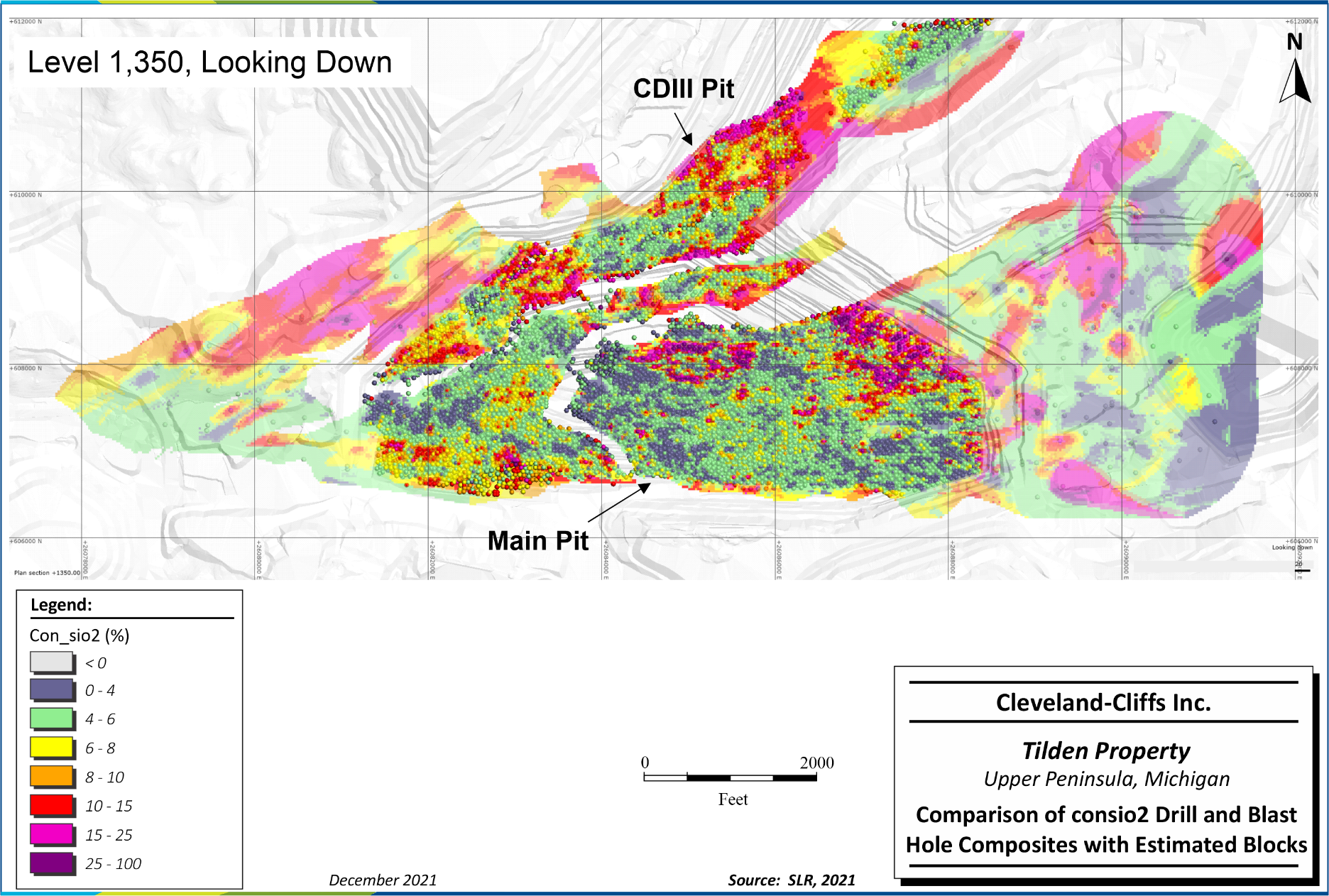
Figure 11-7: Comparison of consio2 Drill and Blast Hole Composites with Estimated Blocks | 91 |
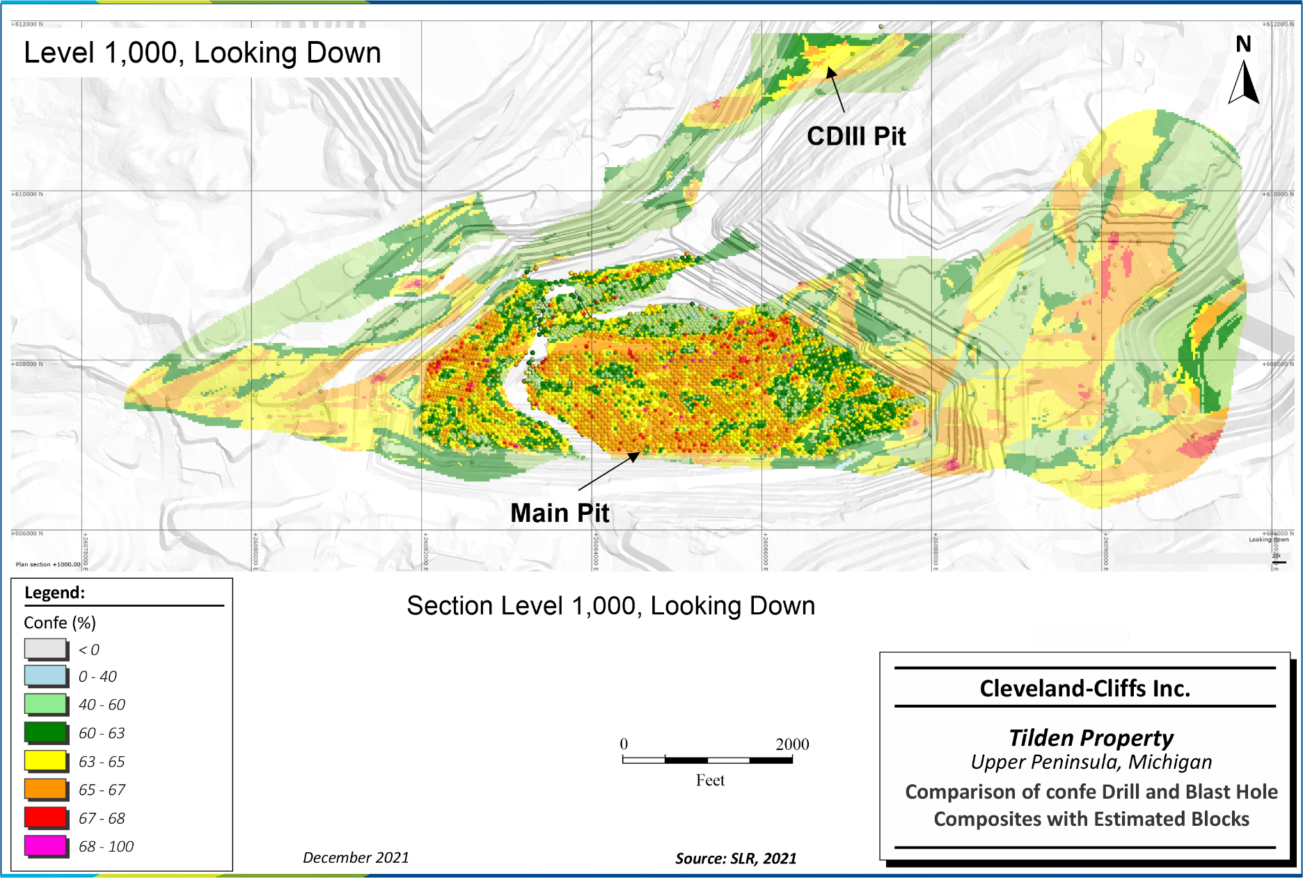
Figure 11-8: Comparison of confe Drill and Blast Hole Composites with Estimated Blocks | 92 |
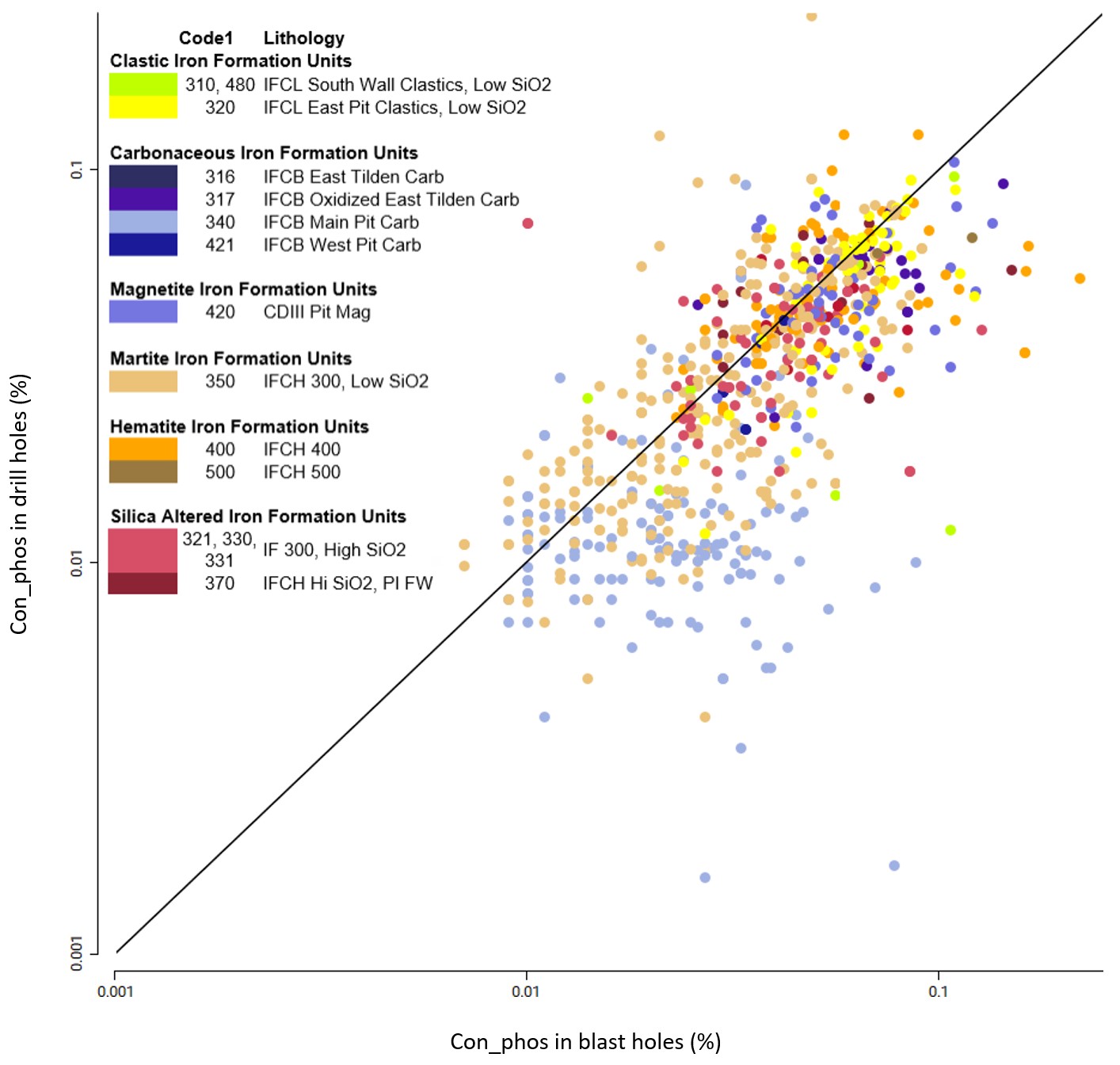
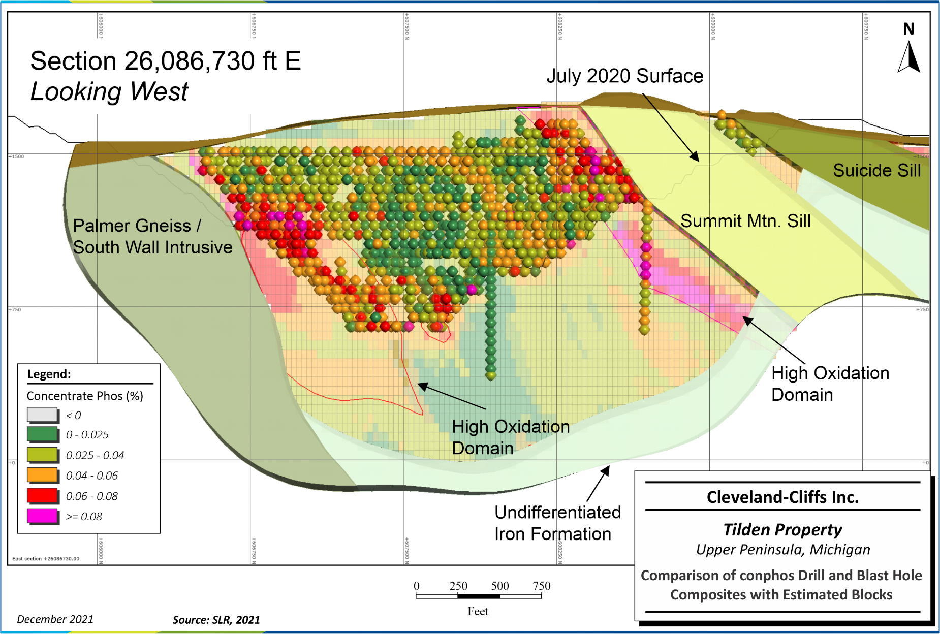
Figure 11-9: Comparison of conphos Drill and Blast Hole Composites with Estimated Blocks | 93 |
| |
| |
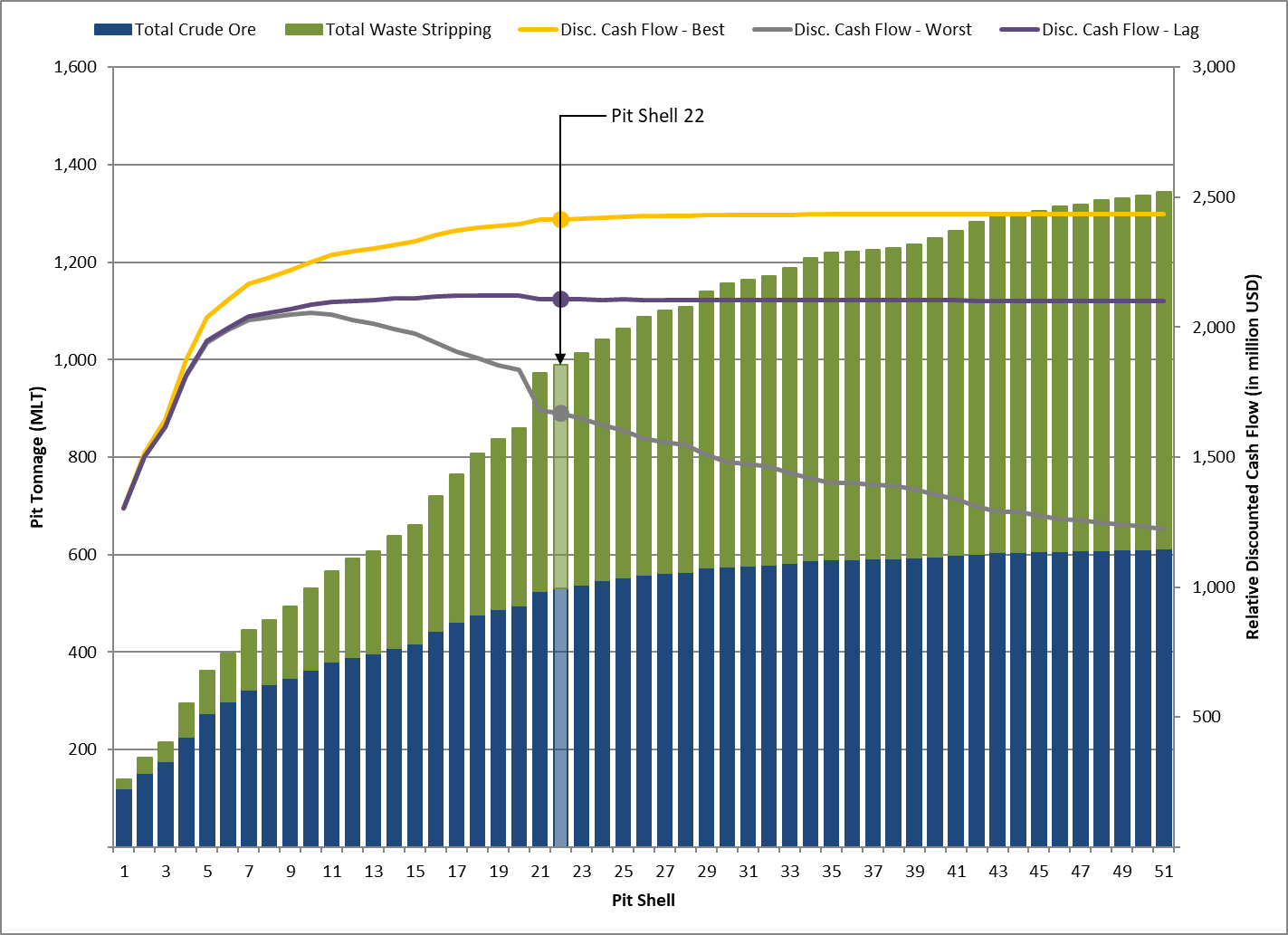
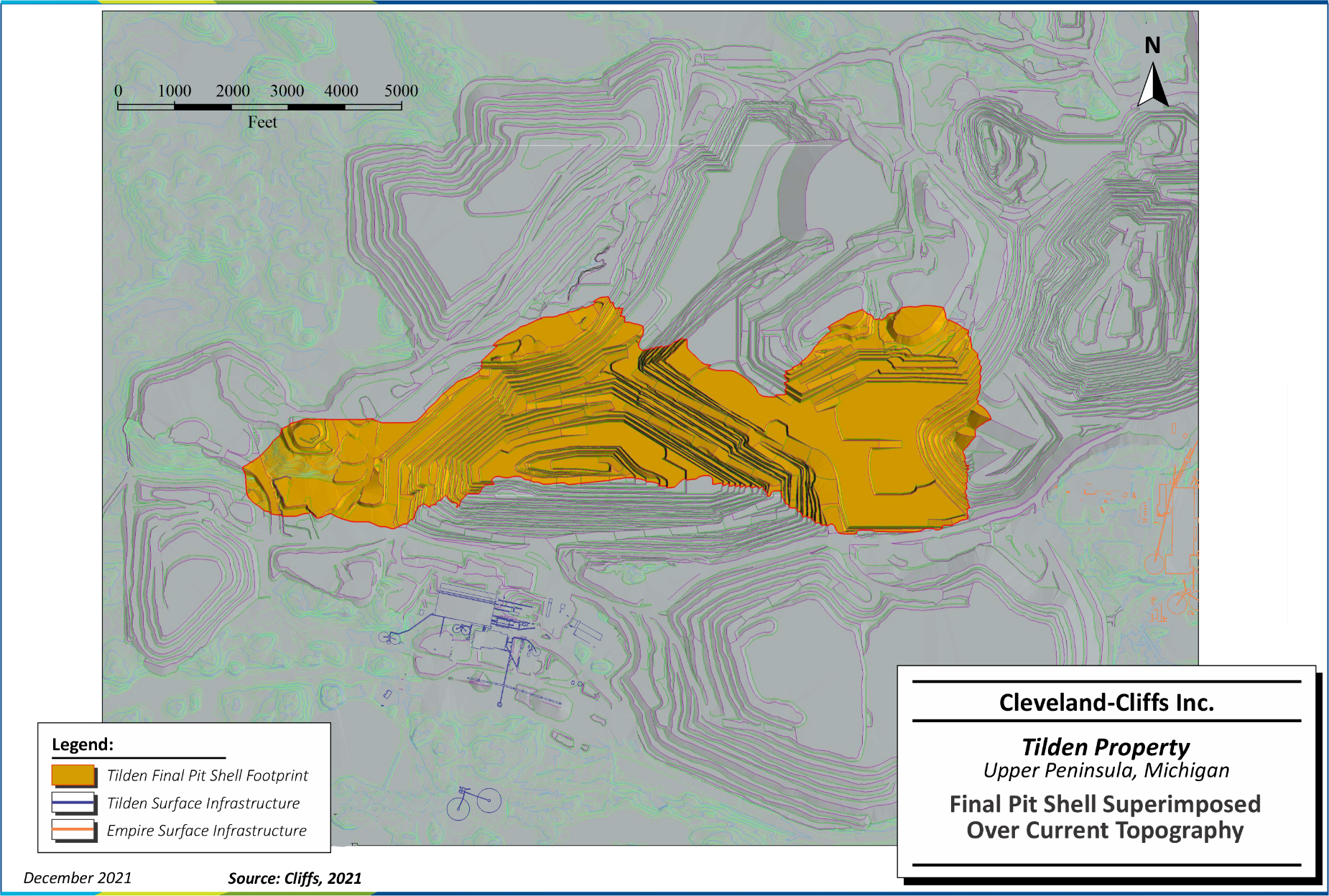
Figure 12-3: Final Pit Shell Superimposed Over Current Topography | 105 |
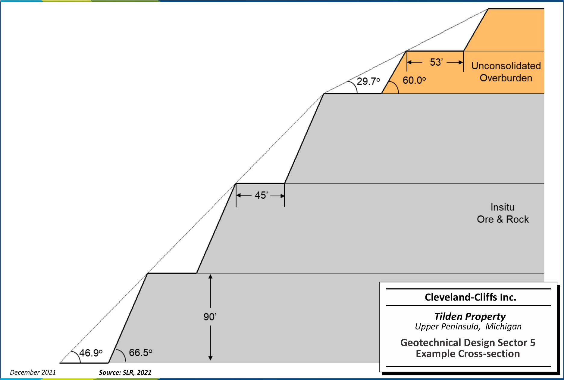
Figure 13-1: Geotechnical Design Sector 5 Example Cross-section | 110 |
Figure 13-2: Plan Map of Pit Slope Geotechnical Design Sectors | 111 |
Figure 13-3: Final Pit Plan View | 116 |
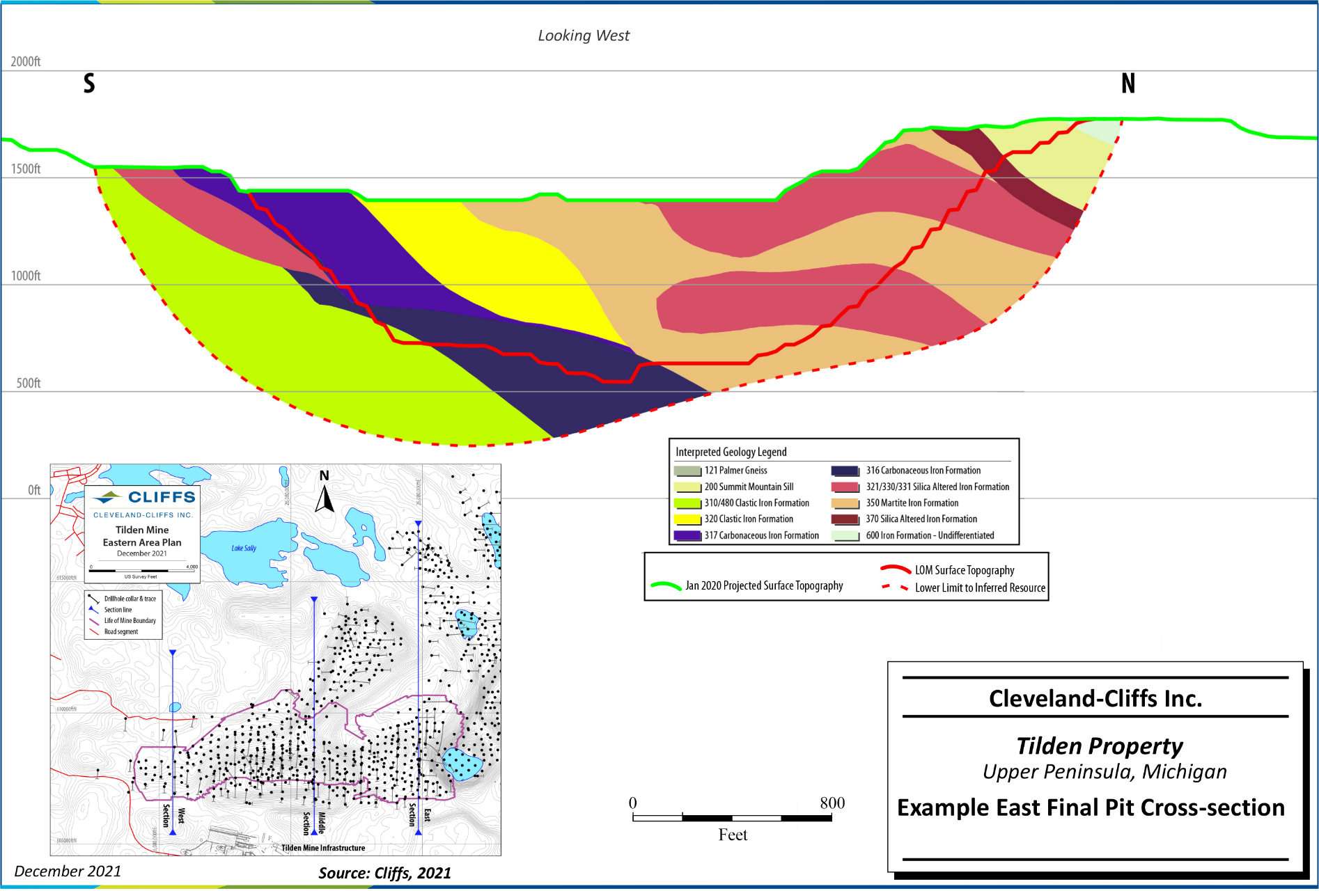
Figure 13-4: Example East Final Pit Cross-section Looking West | 117 |
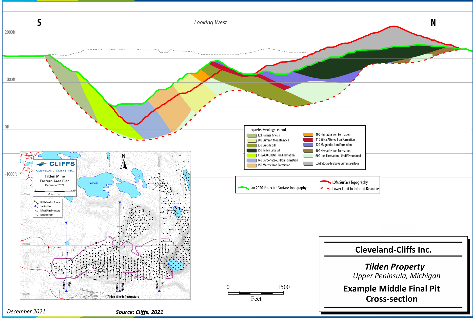
Figure 13-5: Example Middle Final Pit Cross-section Looking West | 118 |
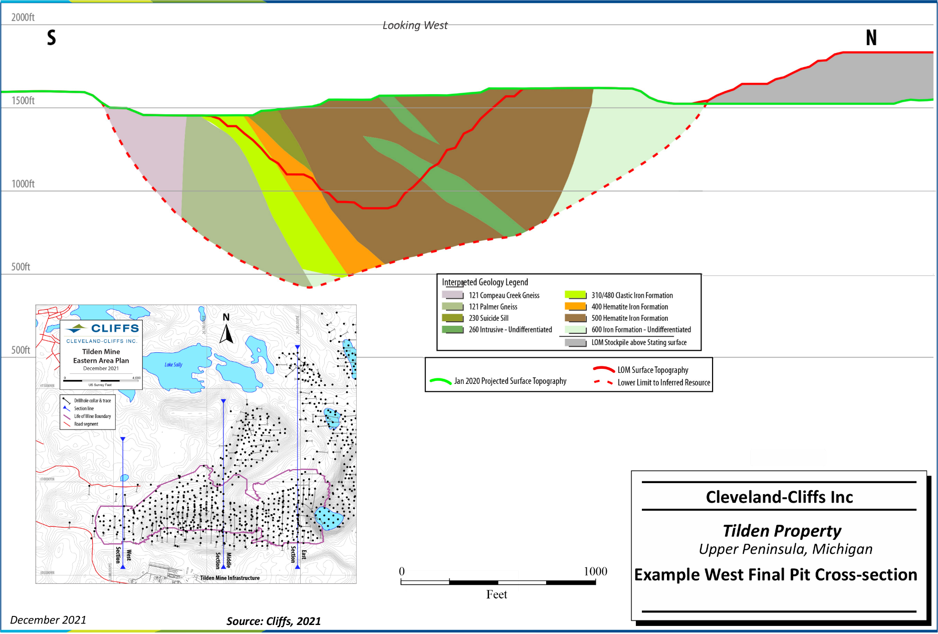
Figure 13-6: Example West Final Pit Cross-section Looking West | 119 |
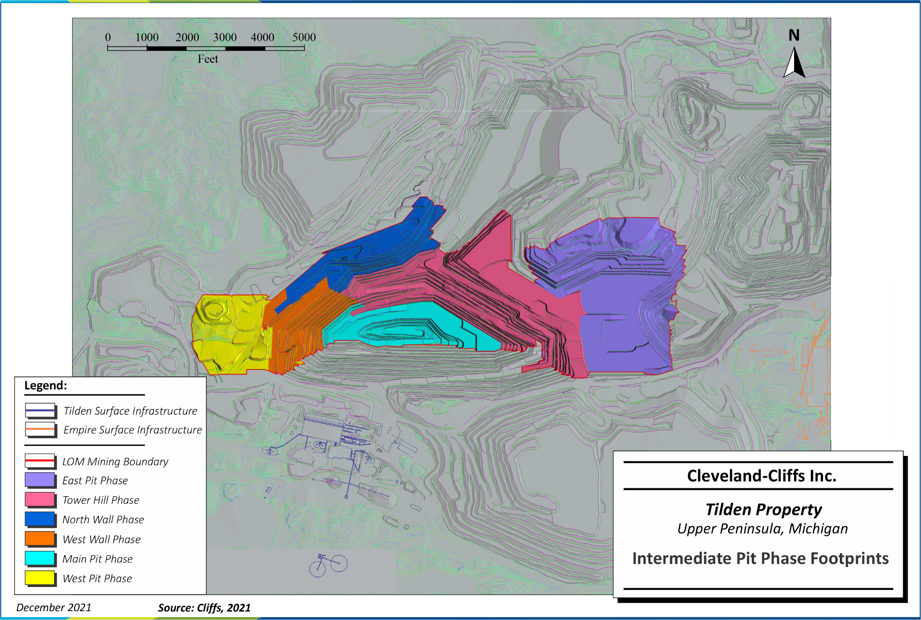
Figure 13-7: Intermediate Pit Phase Footprints | 121 |
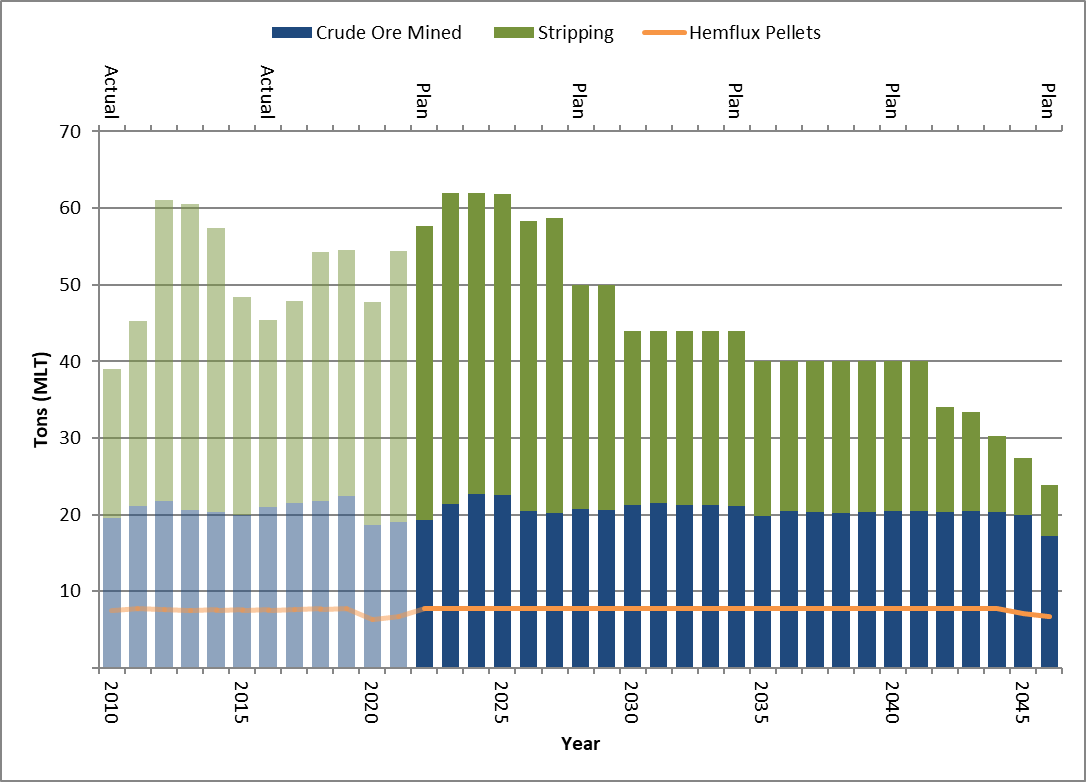
Figure 13-8: Past and Forecast LOM Production | 124 |
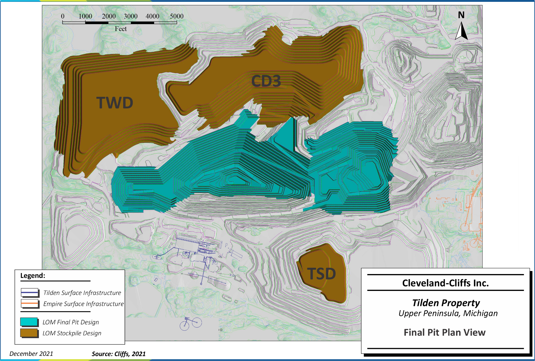
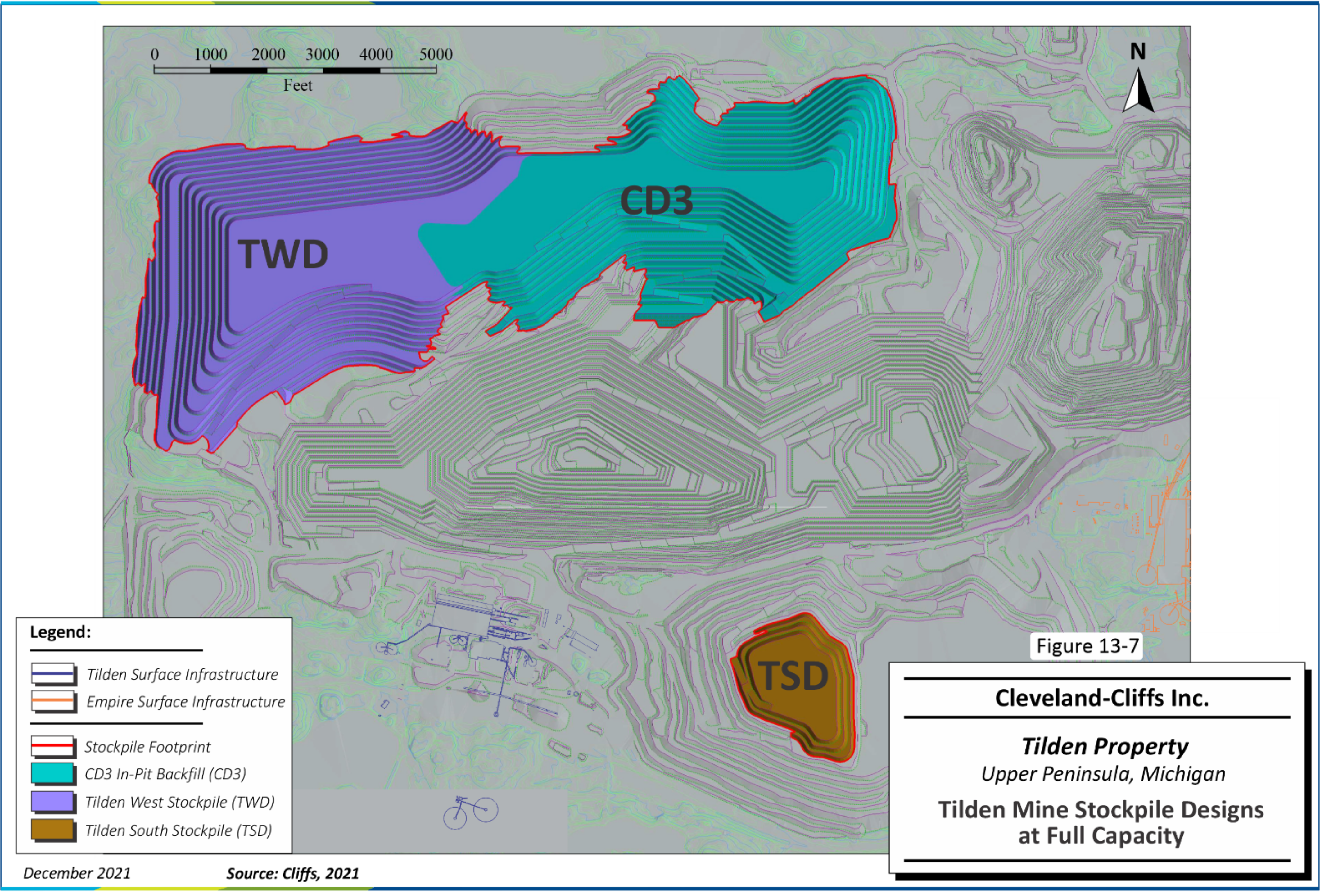
Figure 13-9: Tilden Mine Stockpile Designs at Full Capacity | 126 |
Figure 14-1: Hematite Circuit Process Flowsheet | 131 |
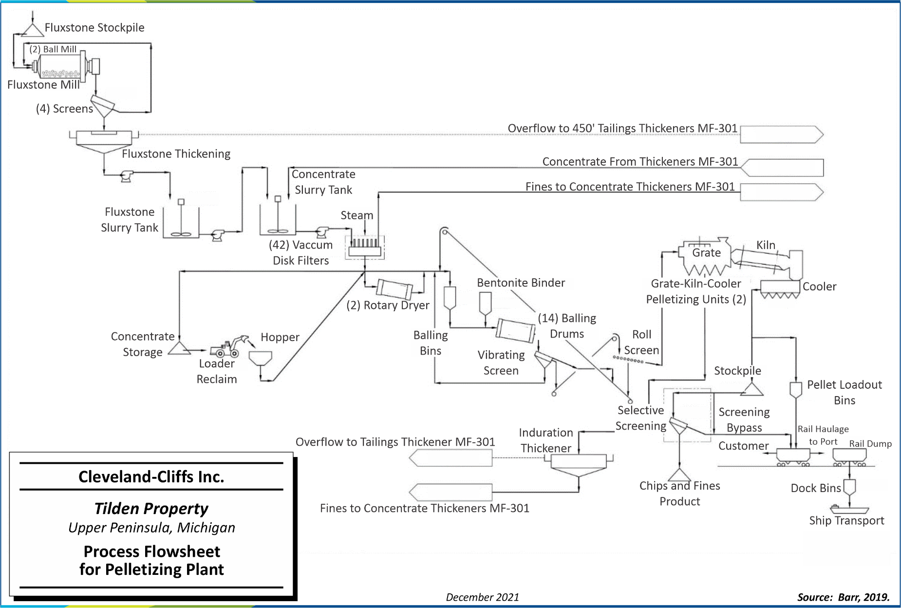
Figure 14-2: Process Flowsheet for Pelletizing Plant | 133 |
| |
| |
| |
| |
| |
| |
| |
Cleveland-Cliffs Inc. | Tilden Property, SLR Project No: 138.02467.00001Technical Report Summary - February 7, 2022 vii
1.0EXECUTIVE SUMMARY
1.1Summary
SLR International Corporation (SLR) was retained by Cleveland-Cliffs Inc. (Cliffs) to prepare an independent Technical Report Summary (TRS) for the Tilden Property (Tilden or the Property), located in Northern Michigan, USA. The owner of the Property, Tilden Mining Company L.C. (Tilden L.C.), is a wholly owned subsidiary of Cliffs.
The purpose of this TRS is to disclose year-end (YE) 2021 Mineral Resource and Mineral Reserve estimates for Tilden.
Cliffs is listed on the New York Stock Exchange (NYSE) and currently reports Mineral Reserves of pelletized ore in SEC filings. This TRS conforms to the United States Securities and Exchange Commission’s (SEC) Modernized Property Disclosure Requirements for Mining Registrants as described in Subpart 229.1300 of Regulation S-K, Disclosure by Registrants Engaged in Mining Operations (S-K 1300) and Item 601 (b)(96) Technical Report Summary. SLR visited the Property on October 24, 2019 and January 20 to 24, 2020.
The Property includes the Tilden Mine (the Mine) and processing facility (the Plant) located approximately five miles south of the city of Ishpeming, Michigan. The Property is also immediately west of Cliffs’ Empire Property, which was indefinitely idled in 2016. The Mine is a large, operating, open-pit iron mine and is unique among Cliffs’ US-owned operations because the primary ore mineral at Tilden is hematite, with other minerals being martite (oxidized pseudomorph of magnetite), goethite, and siderite (iron carbonate mineral), as opposed to strictly magnetite. The Property is also unique in the world in that the hematite-dominant ore is mined at a low grade, concentrated using a selective-flocculation desliming and flotation process, and pelletized.
The Property commenced operations in 1974 under a partnership of Algoma Steel, Stelco, J&L Steel, Wheeling-Pittsburgh Steel, Sharon Steel, and The Cleveland-Cliffs Iron Company (CCIC). The property has since been at least partially in the possession of a subsidiary of Cliffs. In 2001, Cliffs acquired Algoma Steel's 45% interest in Tilden L.C. In 2017, Cliffs became the sole owner of Tilden L.C.
The open-pit operation has a mining rate of approximately 21 million long tons (MLT) of ore per year and produces 7.7 MLT of iron ore pellets per year, which are mostly shipped by freighter via the Great Lakes to Cliffs’ steel mill facilities in the Midwestern USA, with some quantities shipped by rail to external customers.
1.1.1Conclusions
Tilden has successfully produced iron ore pellets for over 47 years. The update to the Mineral Resource and Mineral Reserve does not materially change any of the assumptions from previous operations. An economic analysis was performed using the estimates presented in this TRS and confirms that the outcome is a positive cash flow that supports the statement of Mineral Reserves for a 25-year mine life.
SLR offers the following conclusions by area.
Cleveland-Cliffs Inc. | Tilden Property, SLR Project No: 138.02467.00001
Technical Report Summary - February 7, 2022 1
1.1.1.1Geology and Mineral Resources
•Indicated Mineral Resources at Tilden, exclusive of Mineral Reserves, are estimated to total 135.4 MLT at a grade of 34.7% crude Fe. Inferred Mineral Resources are estimated to total 350.4 MLT at a grade of 34.7% crude Fe.
•The 2019 quality assurance and quality control (QA/QC) program as designed and implemented by Cliffs has been helpful to understand the precision and accuracy of sample analysis at the Tilden laboratory, which is used to support the assay results within the database and confirm that the database is suitable for use in estimating Indicated and Inferred Mineral Resources.
•The Tilden database is adequate for the purposes of estimating Indicated and Inferred Mineral Resources. The lack of regular QA/QC sample submissions alongside samples used to support Mineral Resources is outside of industry-standard practice, and there are several database integrity issues that require attention.
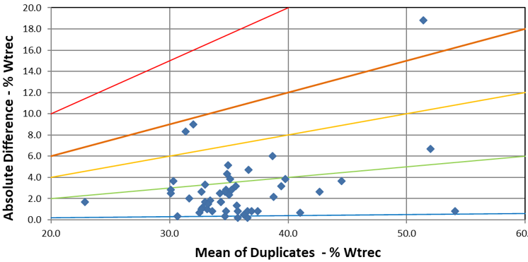
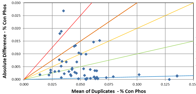
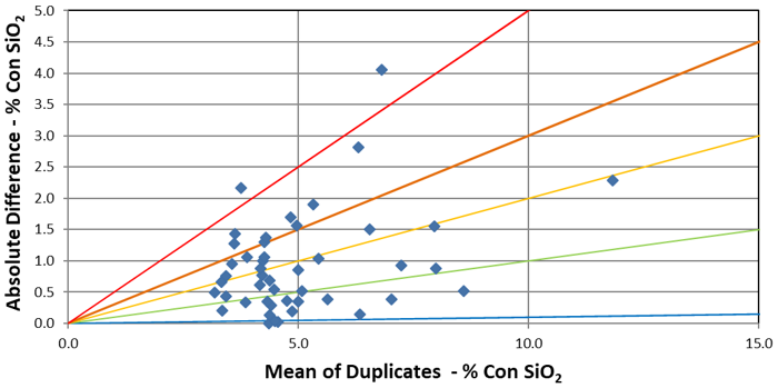
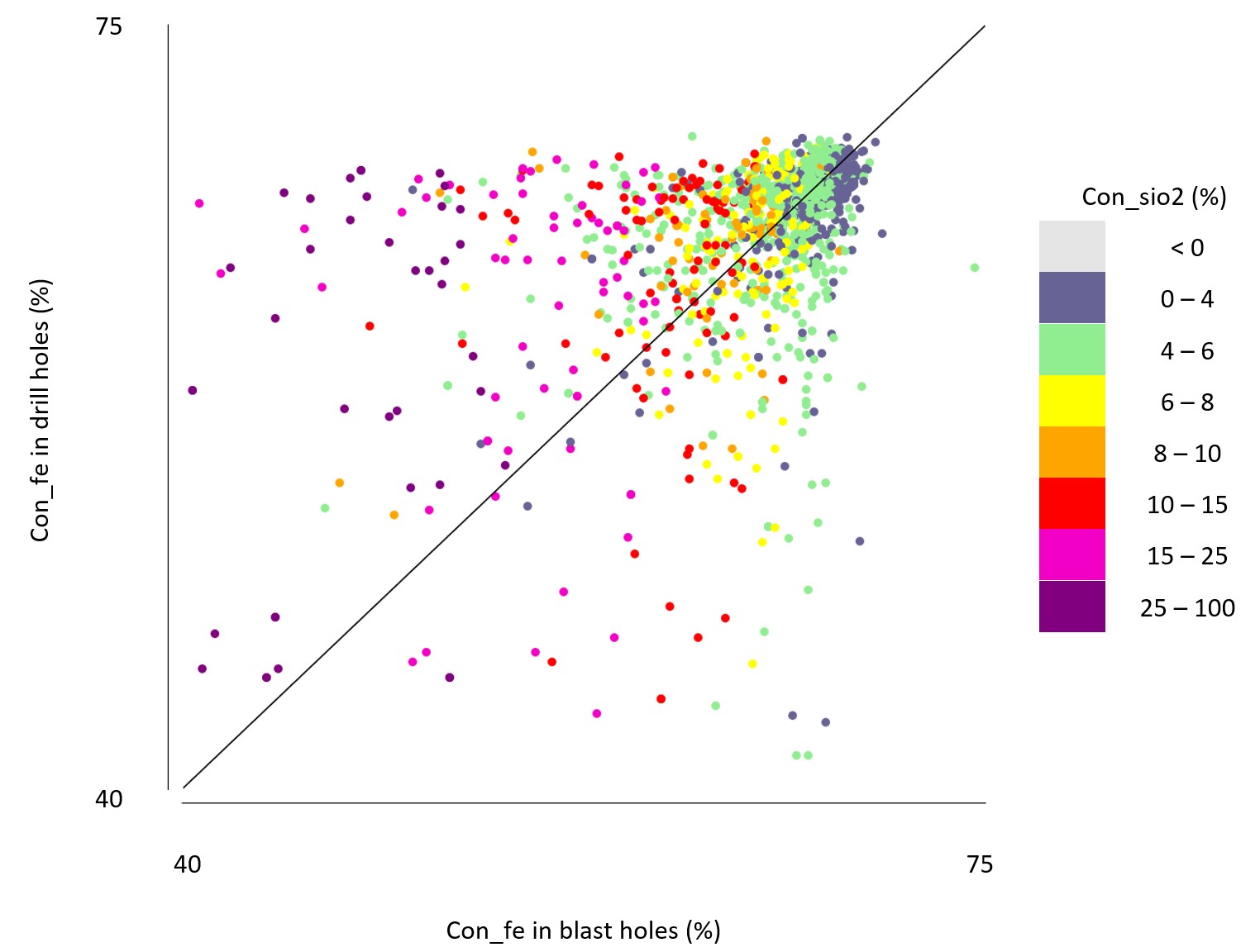
•There is a moderate to good correlation of all variables between drill and blast hole twinned samples. Correlation of iron content values decreases for samples with high silica in concentrate values. There is a potential high bias of phosphorus in concentrate values in favor of blast holes. The known bias of weight recovery (wtrec) in favor of blast hole data is not observable in the paired dataset.
•The estimated block grades reflect the local blast hole or drill hole composite value, and the trends of the different variables are as intended.
1.1.1.2Mining and Mineral Reserves
•The Property has been in production since 1974, and specifically under 100% Cliffs operating management since 2017. Cliffs conducts its own Mineral Reserve estimations.
•Total Proven and Probable Mineral Reserves are estimated at 520.0 MLT of crude ore at a grade of 34.7% crude Fe.
•Mineral Reserve estimation practices follow industry standards.
•The Mineral Reserve estimate indicates a sustainable project over a 25-year life of mine (LOM).
•The geotechnical design parameters used for pit design are reasonable and support previous operations. Slope depressurization may be required as part of the development of the final pit walls.
•The LOM production schedule is reasonable and incorporates large mining areas and open benches.
•An appropriate mining equipment fleet, maintenance facilities, and manpower are in place, with additions and replacements estimated, to meet the LOM production schedule requirements.
•Sufficient storage capacity for waste stockpiles and tailings has been identified to support the production of the Mineral Reserve.
1.1.1.3Mineral Processing
•The Tilden deposit is complex and requires metallurgical testing to classify materials as ore and waste. A standard flotation testing procedure has been developed for material classification, resource modeling, and concentrator feed blending.
Cleveland-Cliffs Inc. | Tilden Property, SLR Project No: 138.02467.00001
Technical Report Summary - February 7, 2022 2
•The capacity of the Tilden concentrator and pellet plant is 7.7 MLT per year (MLT/y) of fluxed pellets (hemflux) from hematite-dominant crude ore sources.
•The ore is amenable to autogenous grinding (AG), and the concentrator consists of eleven lines of primary autogenous mills for coarse grinding and pebble mills for fine grinding, eliminating the requirement for steel grinding media.
•Pellets are indurated using a gas- and coal-fired grate drying and preheating furnace, followed by gas- and coal-fired rotary kilns for fusing and hardening, and rotary coolers for cooling. Heat must be supplied by fuel for low-magnetite concentrates, without the benefit of the exothermic heat of reaction from magnetite oxidation to hematite during heating.
•Crude iron ore head grades feeding the Plant during 2014 to 2020 ranged from 34.4% Fe to 35.5% Fe. Iron recovery to flotation concentrates ranged from 69.6% to 74.8%, with concentrate grades averaging 62.2% to 63.7% during this period. Approximately 20.5 MLT of crude ore is processed through the concentrator annually to produce 8.9 MLT of fluxed concentrate and 7.7 MLT of fluxed pellets (hemflux).
1.1.1.4Infrastructure
•The Property is in a historically important, iron-producing region of Northern Michigan. All the infrastructure necessary to mine and process commercial quantities of iron ore and produce and ship pellets is in place, including the Mine, concentrator, and support facilities, line power supplies, natural gas sourced from an interstate pipeline system, local supply of coal, and diesel fuel supply from Green Bay, Wisconsin.
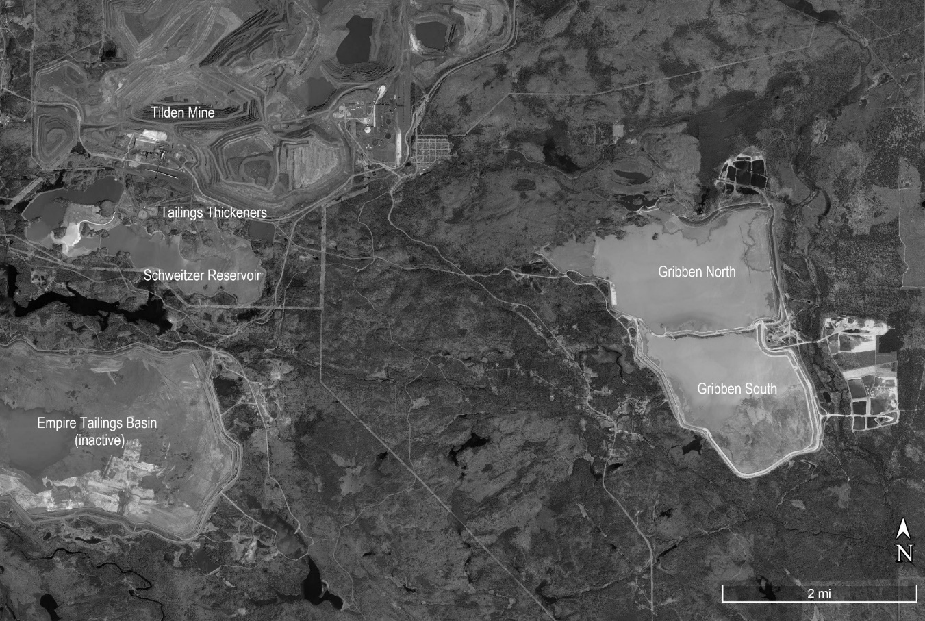
•The Gribben Tailings Basin (GTB) is located approximately five miles southeast of the Tilden concentrator plant and nine miles from Lake Superior. The GTB is comprised of two, ring dike-type impoundments: the Gribben North Tailings Basin (GNTB), which encompasses approximately 1,350 acres, and the Gribben South Tailings Basin (GSTB), which encompasses approximately 1,100 acres.
1.1.1.5Environment
•Tilden indicated that it maintains the requisite state and federal permits and is in compliance with all permits. Various permitting applications have been submitted to authorities and are pending authorization. Environmental liabilities and permitting are further discussed in Section 17.0.
1.1.2Recommendations
1.1.2.1Geology and Mineral Resources
1.Complete a reconciliation study to support the inclusion of Measured Mineral Resources at Tilden.
2.Complete additional drilling to improve the understanding of the deposit at its periphery and at depth, with a focus on low drill density areas within the 2019 LOM plan, as well as in areas with increased variability, such as the high-silica zones in the east of the Main Pit. Integrate the downhole information from the Empire and Tilden mines into a single, valid database.
Cleveland-Cliffs Inc. | Tilden Property, SLR Project No: 138.02467.00001
Technical Report Summary - February 7, 2022 3
3.Develop a standard operating procedure for detailed logging of drill core that captures iron speciation, alteration, mineralogy, structure, and lithology. Retain initial geological observations in drill core separately from subsequent re-interpretations based on metallurgical results or results of neighboring drill holes.
4.Undertake a study where samples are consistently taken at shorter intervals, broken by geology, to examine how the variance of the assays is affected and how the material-type designation, based on a calculation of those variables, compares against the material-type designation of longer samples. Sample intrusive material (dilution) too small to be segregated when modeling or mining as part of iron formation unit samples.
5.Continue work to define fault orientations and related alteration in the east of the Main Pit to confirm the syn-bedding and cross-cutting directions of the modeled, high-silica alteration units and investigate alternative tools to capture drill hole information, including a magnetometer and hyperspectral and x-ray fluorescence handheld devices to allow empirical measurements of magnetism (where relevant), alteration, such as clay, and iron speciation.
6.Develop and implement a robust QA/QC program at Tilden for both exploration drill hole and blast hole samples and incorporate analytical attribute data, such as grind time, starch type, and dates into the assay database, to be able to analyze results in context of changing test protocols for performance and bias.
7.Address capacity issues at the Tilden laboratory to allow the sample analysis to be completed in a timely manner and to facilitate the inclusion of QA/QC samples.
1.1.2.2Mining and Mineral Reserves
1.Assess groundwater conditions in the immediate vicinity of the final pit through a more focused groundwater model. The results of this assessment should be input into an update of the pit slope stability analysis on sections cut through the current final pit design.
1.1.2.3Mineral Processing
1.Continue specialized metallurgical testing to support resource modeling and mine planning and blending for the concentrator.
2.Plant operational performance including concentrate and pellet production and pellet quality continues to be consistent year over year. It is important to maintain diligence in process-oriented metallurgical testing and in plant maintenance.
1.1.2.4Infrastructure
1.Prioritize the completion of an Operations, Maintenance, and Surveillance (OMS) Manual for the tailings storage facility (TSF) with the Engineer of Record (EOR) in accordance with Mining Association of Canada (MAC) guidelines and other industry-recognized standard guidance for tailings facilities.
2.Document, prioritize, track, and close out in a timely manner the remediation, or resolution, of items of concern noted in TSF audits or inspection reports.
3.Assess the impacts of depositing tailings in the Empire facility, and prepare the necessary design and permitting documents.
Cleveland-Cliffs Inc. | Tilden Property, SLR Project No: 138.02467.00001
Technical Report Summary - February 7, 2022 4
1.2Economic Analysis
1.2.1Economic Criteria
An un-escalated technical-economic model was prepared on an after-tax, discounted cash flow (DCF) basis, the results of which are presented in this subsection. Key criteria used in the analysis are discussed in detail throughout this TRS. General assumptions used are summarized in Table 1-1, with all pellets reported per wet long ton (WLT) pellet.
Table 1-1: Technical-Economic Assumptions
Cleveland-Cliffs Inc. – Tilden Property
| | | | | |
| Description | Value |
| Start Date | December 31, 2021 |
| Mine Life | 25 years |
| Three-Year Trailing Average Revenue | $98/WLT Pellet |
| Operating Costs | $66.00/WLT Pellet |
| Sustaining Capital Costs (after five years) | $4/WLT Pellet |
| Discount Rate | 10% |
| Discounting Basis | End of Period |
| Inflation | 0.0% |
| Federal Tax Rate | 20% |
| State Tax Rate | None – Sales made out of state |
Table 1-2 presents a summary of the estimated mine production over the 25-year LOM.
Table 1-2: LOM Production Summary
Cleveland-Cliffs Inc. – Tilden Property
| | | | | | | | |
| Description | Units | Value |
| Run of Mine (ROM) Ore | MLT | 520.0 |
| Total Material | MLT | 1,116.9 |
| Fe Grade | % | 34.7 |
| Average Annualized Mining Rate | MLT/y | 44 |
| Maximum Annualized Mining Rate | MLT/y | 62 |
Table 1-3 presents a summary of the estimated plant production over the 25-year LOM.
Cleveland-Cliffs Inc. | Tilden Property, SLR Project No: 138.02467.00001
Technical Report Summary - February 7, 2022 5
Table 1-3: LOM Plant Production Summary
Cleveland-Cliffs Inc. – Tilden Property
| | | | | | | | |
| Description | Units | Value |
| ROM Material Milled | MLT | 520.0 |
| Average Annualized Processing Rate | MLT/y | 20.8 |
| Process Recovery | % | 37.0 |
| Total Hemflux Pellet | MLT | 192.4 |
| Annual Hemflux Pellet Production | MLT/y | 7.7 |
1.2.2Cash Flow Analysis
The indicative economic analysis results, presented in Table 1-4, indicate an after-tax Net Present Value (NPV), using a 10% discount rate, of $1,325 million at an average blended wet pellet price of $98/WLT. SLR notes that Internal Rate of Return (IRR) is not applicable, as the Property has been in operation for a number of years. Capital identified in the economics is for sustaining operations and plant rebuilds as necessary.
The economic analysis was performed using the estimates presented in this TRS and confirms that the outcome is a positive cash flow that supports the statement of Mineral Reserves.
Table 1-4: LOM Indicative Economic Results
Cleveland-Cliffs Inc. – Tilden Property
| | | | | | | | |
| Description | US$ Millions | US$/WLT Pellet |
| Three-Year Trailing Revenue ($/WLT Pellet) | | 98 |
| Pellet Production (MWLT) | 192.4 | |
| Gross Revenue | 18,854 | |
| Mining | (2,944) | 15.30 |
| Processing | (8,233) | 42.79 |
| Site Administration | (547) | 2.84 |
| General / Other Costs | (975) | 5.07 |
| Total Operating Costs | 12,698 | 66.00 |
| Operating Income (excl. D&A) | 6,156 | 32.00 |
| Federal Income Tax | (1,231) | (6.40) |
| Depreciation Tax Savings | 209 | 1.09 |
| Accretion Tax Savings | 13 | 0.07 |
| Net Income after Taxes | 5,146 | 26.75 |
| Capital | (894) | (4.65) |
| Closure Costs | (57) | (0.30) |
| Cash Flow | 4,196 | 21.81 |
| NPV 10% | 1,322 | |
Cleveland-Cliffs Inc. | Tilden Property, SLR Project No: 138.02467.00001
Technical Report Summary - February 7, 2022 6
1.2.3Sensitivity Analysis
The Tilden operation is nominally most sensitive to market prices (revenues) followed by operating cost. For each dollar movement in sales price or operating cost, respectively, the after-tax NPV changes by approximately $56 million.
1.3Technical Summary
1.3.1Property Description
The Property is located in Marquette County in Michigan’s Upper Peninsula, USA, on the Marquette Iron Range, approximately five miles south of the city of Ishpeming, Michigan at latitude 46° 29' N and longitude 87° 40' W. The Property is also immediately adjacent to Cliffs’ indefinitely idled Empire Mine and processing facility. The Mine and Plant have the capacity to produce approximately 7.7 MLT of iron ore pellets annually.
Land ownership and mineral leases are held by Tilden L.C. Cliffs, through its subsidiary CCIC, owns 100% of the surface and mining rights. In addition, Cliffs owns 100% of Tilden L.C. Tilden L.C. owns 21,100 acres of surface rights and 2,470 acres of mineral leases in Marquette County.
1.3.2Accessibility, Climate, Local Resources, Infrastructure, and Physiography
The Property can be accessed from the west through the Tilden entrance gate near the community of National Mine, located two miles south of Ishpeming on County Road 476. Alternatively, the Property can be accessed from the east through the adjacent Empire Mine. The Empire entrance gate is located on M-35, nine miles south of US Highway 41 between Marquette and Negaunee.
Michigan’s Upper Peninsula has a humid continental climate, typified by large seasonal temperature differences. Summers are generally warm and humid; winters are cold and long. Precipitation in the area averages approximately 31 in. of rain and 102 in. of snow in the winter. Snowfall in the region is greatly influenced by the “lake effect” due to proximity to the Great Lakes. Many towns in the Upper Peninsula have recorded annual snowfalls in excess of 350 in., and storms can quickly reach whiteout conditions and last for days.
The operation employs a total of 967 salaried and hourly employees (including LS&I railroad staff) as of Q4 2021. The majority of the employees live within a 50 mi radius of the Property. Marquette County has an estimated population of 66,000 people.
The Property is located in a historically important, iron-producing region in Northern Michigan. All infrastructure necessary to mine and process significant commercial quantities of iron ore exist at the current time. Infrastructure items include administration buildings and offices, maintenance shops, high-voltage electrical supplies, natural gas pipelines that connect into the North American distribution system, concentrating plant, pelletizing plant, water sources, paved roads and highways, railroads for transporting raw materials and final product, port facilities that connect into the Great Lakes and towns where employees live.
The Property is within the limits of a topographic region known as the Superior Uplands, a part of the Canadian Shield. The Property features elevations ranging from approximately 1300 to 1800 ft above sea level (fasl). Topography is hilly and is dominated by glacially influenced landforms. The Property is located in the Western Upper Peninsula Ecoregion (Section IX) and characterized by a landscape
Cleveland-Cliffs Inc. | Tilden Property, SLR Project No: 138.02467.00001
Technical Report Summary - February 7, 2022 7
featuring moraines, drumlins, lake plains, outwash channels, outwash plains, and glacially eroded bedrock ridges (Albert, 1995). Vegetation in the vicinity of Tilden is described as northern hardwood forest dominated by sugar maple, eastern hemlock, basswood, yellow birch, and sparse white pine.
1.3.3History
Iron deposits in Northern Michigan were originally described in the early 1840s by Douglass Houghton, Michigan’s first State Geologist. Exploration and mining of high-grade iron oxides began in the mid to late 1840s, including Cliffs’ predecessors Cleveland Iron Company and Iron Cliffs Company, which merged in 1891 to form the CCIC. Mining was mainly focused on underground, high-grade iron deposits through the end of the Second World War, when they were almost depleted.
Extensive development of beneficiation-grade, open pit mining began, and the first commercial agglomeration (pellet) plant in the Lake Superior region started operations in 1952. Agglomeration was a relatively new process that took the concentrate from lower-grade deposits and produced pelletized product containing approximately 65% Fe.
After years of favorable experimental testing for processing of fine-grained hematite ores, the Property commenced operations in 1974 under a partnership of Algoma Steel, Stelco, and CCIC. The Property has since been at least partially in the possession of a subsidiary of Cliffs. In 2001, Cliffs acquired Algoma Steel's 45% interest in Tilden L.C. In 2017, Cliffs became the sole owner of the Tilden L.C. entity.
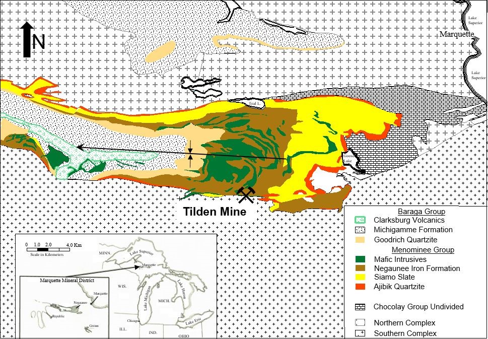
1.3.4Geological Setting, Mineralization, and Deposit
The Tilden deposit is a classic example of a banded iron formation (BIF) deposit of the Superior type and is located near the base of the Negaunee Iron Formation (Negaunee IF) of the Menominee Group, within the Marquette Range Super Group. The Negaunee IF and equivalents host most of the iron deposits in Michigan. It is Proterozoic in age and sits on the southern margin of the Marquette trough.
The deposit is modeled to extend from surface to up to 2,300 ft vertical depth below and is comprised of alternating layers of iron oxides and iron-poor chert in a northwest-plunging anticline; the axial surface dips steeply north, and the hinge line plunges 30° west-northwest down the center of the Main Pit. It is fault-bounded to the south by Archean gneiss terrane; the fault contact dips steeply north and aligns with the south wall of the Main Pit at Tilden. To the east of the Tilden deposit lies the Empire deposit (a stratigraphically deeper extension of the Tilden deposit) and its historical pit. Tilden is impacted by a higher frequency and volume of intrusions and sills northward, but is open to the west, at depth, and in some areas to the north.
The iron formation facies at Tilden were locally modified by clay-silica alteration associated with faulting and intrusions, as well as by varying degrees of oxidation throughout. Some BIF units in the south were disrupted by turbidite flows, typified by lensoidal inclusions of clastic material.
The Tilden Mine is unique among Cliffs-owned operations because the primary ore mineral at Tilden is hematite, with other minerals being martite (oxidized pseudomorph of magnetite), goethite, and siderite (iron carbonate mineral), as opposed to strictly magnetite. Tilden is also unique in the world in that the hematite-dominant ore is mined at a low grade, concentrated using a selective-flocculation desliming and flotation process, and pelletized. Although some now-expended areas at Tilden did mine and magnetically recover magnetite-dominant ore prior to 2009, remaining Mineral Resources at Tilden
Cleveland-Cliffs Inc. | Tilden Property, SLR Project No: 138.02467.00001
Technical Report Summary - February 7, 2022 8
are hematite-dominant. The adjacent (now indefinitely idled) Empire deposit hosted primarily magnetite ore, and unoxidized magnetite is variably present at Tilden.
1.3.5Exploration
Cliffs and Tilden Mine do not maintain detailed records or results of non-drilling prospecting methods used during initial exploration activities, such as geophysical surveys, mapping, trenching, and test pits, conducted prior to Cliffs’ development of the operation. No exploration work or investigations other than drilling and limited pit mapping have been conducted by Cliffs at Tilden.
The Tilden drill hole database consists of 382,605 ft of drill hole information in 578 drill holes, completed from the 1950s to 2020. Annual exploration drilling programs at Tilden have completed zero to 42 drill holes. Of the last 10 years, nine have included drill hole programs and have averaged 10 drill holes per year. Diamond, hammer, and churn drilling have all been employed at Tilden, with diamond drilling having been exclusively used since 2008.
1.3.6Mineral Resource Estimates
A geological model was constructed by SLR considering regional mapping, drill hole logging, and blast hole analytical results, in addition to grade control modeling and flotation ore coding. Data verification included standard database verification, a review of QA/QC protocols and results, and a comparison of blast hole and exploration drill hole results.
The Tilden Mineral Resource estimate was completed by SLR using a conventional block modeling approach, defining estimation domains from wireframes built in Seequent’s Leapfrog Geo (Leapfrog Geo) software and using a regular block model built and interpolated in Seequent’s Leapfrog Edge (Leapfrog Edge) software. The general workflow included the creation of a geological model from mapping, drill and blast hole logging, and sampling, which were used to define discrete domains of non-iron formation and iron formation sub-units. Iron formation drill hole samples were composited, and the estimation of six variables (crude iron and magnetic iron, wtrec, and iron, phosphorus, and silica in concentrate) was completed using ordinary kriging (OK) over five passes in iron formation units, the first of which incorporated blast hole samples. Distance restriction of outlier grades was applied to selected domains and variables. Blocks were classified as Indicated or Inferred using distance-based and qualitative criterion. Canadian Institute of Mining, Metallurgy and Petroleum (CIM) Definition Standards for Mineral Resources and Mineral Reserves dated May 10, 2014 (CIM (2014) definitions) were used for Mineral Resource classification. Models were depleted to December 31, 2021. Estimates were validated using standard industry techniques and were peer reviewed prior to finalization.
A detailed breakdown of the Mineral Resources exclusive of Mineral Reserves is presented in Table 1-5. Mineral Resources were defined and constrained within an open-pit shell, prepared by Cliffs and based on a US$90/LT pellet price, and meet the following cut-off grade criteria, based on existing pellet specifications and price contracts:
•≥ 25% wtrec
•≥ 25% crude iron content (crudefe)
•≤ 0.07% phosphorus in concentrate (conphos)
•≤ 6% to 8.5% silica in concentrate (consio2) (domain dependent)
Cleveland-Cliffs Inc. | Tilden Property, SLR Project No: 138.02467.00001
Technical Report Summary - February 7, 2022 9
The pellet cost basis for the Lerchs-Grossmann (LG) optimization is based on a dry 61.5% Fe fluxed pellet.
Table 1-5: Summary of Tilden Mineral Resources - December 31, 2021
Cleveland-Cliffs Inc. – Tilden Property
| | | | | | | | | | | | | | |
| Category | Long Tons
(MLT) | Crude Fe
(%) | Process Recovery
(%) | Wet Pellets
(MLT) |
| Measured | - | - | - | - |
| Indicated | 135.4 | 35.5 | 35.9 | 48.6 |
| Total Measured + Indicated | 135.4 | 35.5 | 35.9 | 48.6 |
| Inferred | 350.4 | 34.7 | 36.4 | 127.4 |
Notes:
1.Tonnage is reported in long tons equivalent to 2,240 lb.
2.Tonnage is reported exclusive of Mineral Reserves and has been rounded to the nearest 100,000.
3.Mineral Resources are estimated at cut-off grades of 25% crudefe, 25% wtrec, 0.07% conphos, and 6% consio2 to 8.5% consio2, domain dependent.
4.Mineral Resources are estimated using a pellet value of US$90/LT.
5.Pellets are reported as fluxed and wet, containing 61.5% Fe; shipped pellets contain 1.5% moisture.
6.Tonnage estimate based on estimated depletion from a surveyed topography on December 31, 2021.
7.Resources are crude ore tons as delivered to the primary crusher; pellets are as loaded onto rail cars.
8.Classification of Mineral Resources is in accordance with the S-K 1300 classification system.
9.Bulk density is assigned based on a regression equation related to crude Fe.
10.Mineral Resources are 100% attributable to Cliffs.
11.Mineral Resources are constrained within an optimized pit shell.
12.Mineral Resources that are not Mineral Reserves do not have demonstrated economic viability.
13.Numbers may not add due to rounding.
The Tilden operation is currently active and in full production. The SLR QP is of the opinion that with consideration of the recommendations summarized in this section, any issues relating to all relevant technical and economic factors likely to influence the prospect of economic extraction can be resolved with further work.
1.3.7Mineral Reserve Estimate
Mineral Reserves in this TRS are derived from the current Mineral Resources. The Mineral Reserves are reported as crude ore and are based on open pit mining. Crude ore is the unconcentrated ore as it leaves the Mine at its natural in situ moisture content. The Proven and Probable Mineral Reserves for Tilden are estimated as of December 31, 2021 and summarized in Table 1-6.
Table 1-6: Summary of Tilden Mineral Reserves - December 31, 2021
Cleveland-Cliffs Inc. – Tilden Property
| | | | | | | | | | | | | | |
| Category | Crude Ore Mineral Reserves
(MLT) | Crude Ore Fe
(%) | Process Recovery (%) | Wet Pellets
(MLT) |
| Proven | 3.6 | 35.3 | 36.1 | 1.3 |
| Probable | 516.4 | 34.7 | 37.0 | 191.1 |
| Proven & Probable | 520.0 | 34.7 | 37.0 | 192.4 |
Notes:
Cleveland-Cliffs Inc. | Tilden Property, SLR Project No: 138.02467.00001
Technical Report Summary - February 7, 2022 10
1.Tonnage is reported in long tons equivalent to 2,240 lb and has been rounded to the nearest 100,000.
2.Mineral Reserves are reported at a $90/LT wet hemflux pellet price freight-on-board (FOB) Lake Superior, based on the three-year trailing average of the realized product revenue rate.
3.Mineral Reserves are estimated at a crude ore cut-off grade of 25.0% Fe along with additional metallurgical constraints.
4.Mineral Reserves include mining dilution built into the Mineral Resource model and mining extraction losses by geometallurgical domain, which range from 4% to 30%.
5.The Mineral Reserve mining stripping ratio (waste units to crude ore units) is at 1.2.
6.Proven Mineral Reserves are crude ore that has been mined and stockpiled for processing during the LOM.
7.Process recovery is reported as the percent mass recovery to produce a wet hemflux pellet containing 61.5% Fe; shipped hemflux pellets average approximately 1.5% moisture.
8.Tonnage estimate is based on the end of year, December 31, 2021 topographic survey.
9.Mineral Reserve tons are as delivered to the primary crusher; wet hemflux pellets are as loaded onto lake freighters at Marquette, Michigan.
10.Classification of Mineral Reserves is in accordance with the S-K 1300 classification system.
11.Mineral Reserves are 100% attributable to Cliffs.
12.Numbers may not add due to rounding.
The pellet price used to perform the evaluation of the Mineral Reserves in the current mining model is US$90/LT wet hemflux pellet. This price is consistent with the Mineral Reserve price used at Cliffs’ Northshore and UTAC operations and is supported by the current three-year trailing average of the realized product revenue rate of US$98/LT wet hemflux pellet. Proven Mineral Reserves consist exclusively of crude ore that has been mined and stockpiled for future processing in the LOM plan. The costs used in this study represent all mining, processing, transportation, and administrative costs including the loading of pellets into lake freighters at Marquette, Michigan.
SLR is not aware of any risk factors associated with, or changes to, any aspects of the modifying factors such as mining, metallurgical, infrastructure, permitting, or other relevant factors that could materially affect the Mineral Reserve estimate.
1.3.8Mining Methods
The Tilden deposit is mined using conventional surface mining methods. The surface operations include:
•Overburden (glacial till) removal
•Drilling and blasting (excluding overburden)
•Loading and haulage
•Crushing and rail loading
The Mineral Reserve is based on the ongoing annual crude ore production of 20 MLT to 22 MLT producing approximately 7.7 MLT of wet hemflux pellets for domestic consumption.
Mining and processing operations are scheduled 24 hours per day, and the mine production is scheduled to directly feed the processing operations.
The current LOM plan has mining scheduled for 25 years and mines the known Mineral Reserve. The average stripping ratio is approximately 1.2 waste units to 1 crude ore unit (1.2 stripping ratio).
The final Tilden pit is a single pit approximately 2.5 mi along strike, up to 0.9 mi wide, and up to 1,980 ft deep.
The Mine’s operation has a strict crude ore blending requirement to ensure the Plant receives a consistent crude ore feed. The most important characteristics of the crude ore are the crude ore iron grade and the predicted concentrate mass recovery and concentrate iron, silica, and phosphorus content. Operationally, blending is done on a shift-by-shift basis. Generally, three to four crude ore
Cleveland-Cliffs Inc. | Tilden Property, SLR Project No: 138.02467.00001
Technical Report Summary - February 7, 2022 11
loading points are mined at one time with dispatch operators issuing real-time adjustments to meet specified crude ore blends for the Plant.
Crude ore is hauled to the crushing facility and either direct tipped to the primary crusher or stockpiled. Haul trucks are alternated to blend delivery from the multiple crude ore loading points. The crude ore stockpiles are used as an additional source for blending and production efficiency. Crushed crude ore is conveyed to a covered storage building for stockpiling prior to being fed to the concentrator. Waste rock and overburden are hauled to one of the many waste stockpiles peripheral to the pit or to the in-pit backfill.
The major pieces of pit equipment include electric drills, electric rope shovels, haul trucks, front-end loaders (FELs), bulldozers, and graders. Extensive maintenance facilities are available at the mine site to service the mine equipment.
1.3.9Processing and Recovery Methods
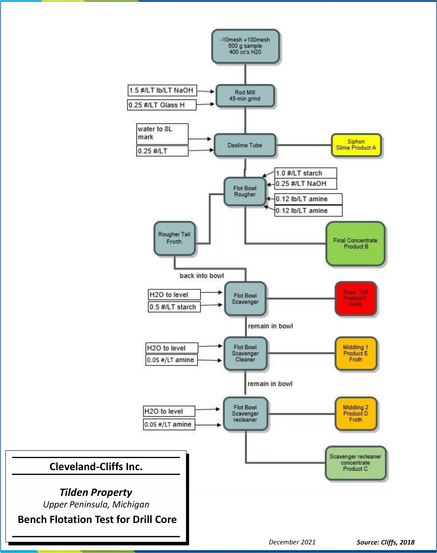
The mix of magnetite and primarily hematite ores at Tilden is unique to US iron ore mines. Typical flowsheets developed for beneficiation-grade magnetite ores of the Lake Superior region were not applicable, as most of the iron oxide occurs as non-magnetic hematite, which requires fine grinding for liberation. Metallurgical research conducted in the 1960s focused on creating a process that included selective flocculation and desliming followed by cationic silica (SiO2) flotation.
A standardized bench-scale flotation test was designed to simulate the Tilden hematite grinding and concentrating circuit. Results from the standardized bench flotation test are used to characterize rock samples as either crude iron ore or waste rock. The data are used to build a resource model and mine plan to supply a consistent blend of ore to the concentrator. Deleterious materials impacting economic extraction are observed in the flotation bench test, which may include clay minerals, quartz inclusions within iron oxide bands, fine goethite, and carbonates.
The capacity of the Tilden concentrator and pellet plant is 7.7 MLT/y of fluxed pellets from both hematite and magnetite crude ore sources. The Plant includes primary crushing, autogenous primary and secondary grinding, selective flocculation and desliming, flotation, filtration, drying, balling (agglomeration), and induration. The concentrator is designed to campaign either hematite ores or magnetite ores but not in combination.
The processing of magnetite-dominant ores at the Tilden concentrator ceased in 2009. Magnetite ore from the Tilden was delivered and processed at the Empire Mine from 2010 through 2016 when the Empire was indefinitely idled. Remaining Mineral Resources and Mineral Reserves at Tilden are processed in hematite-based flotation circuits.
Mined ore is directly dumped from haul trucks into a gyratory crusher to produce a nominal nine-inch crushed product, which is conveyed to the ore storage building ahead of the grinding circuit. Primary grinding is accomplished with eleven primary AG mills, each driven by two, 2,860 hp synchronous motors. Each primary AG mill discharges to a triple-deck screen, producing coarse pebble for pebble mill grinding media, an intermediate product that is recycled to the AG mill, and a 100% passing 2 mm product that feeds the pebble mills. The pebble mills are operated in closed circuit with cyclones to produce a final grind of 80% to 85% passing 25 microns. Caustic soda and slaked lime are added to the water circuit to control pH prior to desliming and flotation.
Cleveland-Cliffs Inc. | Tilden Property, SLR Project No: 138.02467.00001
Technical Report Summary - February 7, 2022 12
Starch and a dispersant are added to the slurry to selectively flocculate and depress the iron oxides while dispersing the fine silica gangue in advance of the deslime thickeners. The deslime thickener overflow, containing the waste products, is fed to the tailings thickeners, and the deslime thickener underflow is conditioned with additional starch and advanced to the flotation circuit.
The reverse flotation circuit is divided into twelve lines, which float silica from the iron minerals with an amine collector. The rougher flotation concentrate represents final upgraded iron concentrate and is advanced to the concentrate thickener. The rougher tail is scavenged in four flotation stages to remove entrained iron values. The scavenger flotation concentrates are recycled to the rougher feed, and scavenger tails are pumped to the tailings thickeners.
The iron concentrate is thickened to approximately 65% to 70% solids in the concentrate thickeners, neutralized to a pH of 7.0 using carbon dioxide, and then filtered in a series of vacuum disc filters to approximately 11.5% weight by weight (w/w) moisture content. Filtered concentrates are either sent directly to the pelletizing plant, a thermal drying circuit, or to a concentrate storage stockpile.
Fluxstone consisting of dolomite and calcite is delivered to site via truck and stored in stockpiles. The material is fed from a stockpile via apron feeders and processed in two, 15.5 ft-diameter x 30 ft-long ball mills. The fluxstone slurry is added to the iron concentrate prior to filtering to ensure homogenous mixing.
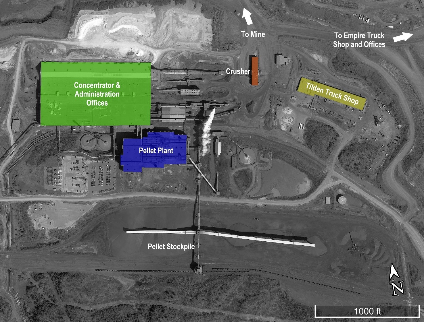
The unit processes of the pelletizing plant include concentrate drying, agglomeration or balling, sizing, and induration in a grate kiln and cooler to produce final pellets, and pellet storage and loadout.
Concentrate is conveyed from filtration or the concentrate stockpile to the balling section of the pelletizing plant. A portion of the concentrate is dried in a rotary dryer and then recombined with the concentrate feed to achieve 9.5% w/w moisture for balling. Green balls are produced in fourteen rotating balling drums operating in parallel. Bentonite clay binder is added to the balling drum feed, and green balls are discharged onto a vibrating seed screen with a two-feet-long grizzly extension for oversize removal. The screen undersize is returned to the balling drum, and the grizzly oversize is returned to the concentrate bin or diverted to outdoor storage. The seed screen product is conveyed by a reciprocating conveyor, which distributes the green balls over a grate feed belt.
The green balls enter a moving grate, which passes through 3.5 bays of updraft drying, 7.5 bays of downdraft drying, and eight bays of downdraft pre-heating and are then discharged into one of two rotary kilns. Heat for the kilns is produced with a combination of pulverized coal and/or natural gas. Product from the kiln is discharged into two rotary coolers, sufficiently cooling the pellets to be transported by conveyor.
Cooled pellets are conveyed directly to either a railroad load-out bin or to an outdoor stockpile with nominal capacity of 2 MLT. Pellets are loaded into rail cars and transported to the dock facility in Marquette, Michigan or shipped directly to customers by rail. Pellet stockpiles are screened to reduce fines using loaders feeding a portable screening plant. Pellet chips and fines from this process are sold as a secondary product.
1.3.10Infrastructure
The Property is in a historically important, iron-producing region in the Upper Peninsula of Northern Michigan. All the infrastructure necessary to mine and process commercial quantities of iron ore is in place.
Cleveland-Cliffs Inc. | Tilden Property, SLR Project No: 138.02467.00001
Technical Report Summary - February 7, 2022 13
Infrastructure items include:
•The Mine, concentrator, and concentrate pelletizing facilities near Marquette, Michigan.
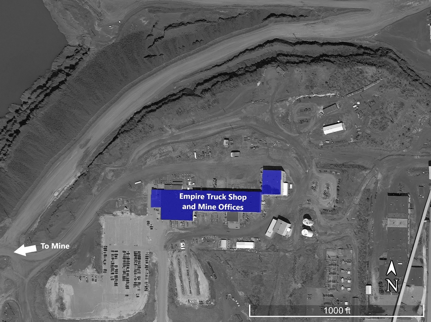
•The main processing facility is contained in a conventional, multi-level, insulated steel building. Mining offices and mobile equipment maintenance shops are separated from the main facility and are located on the Empire Mine property.
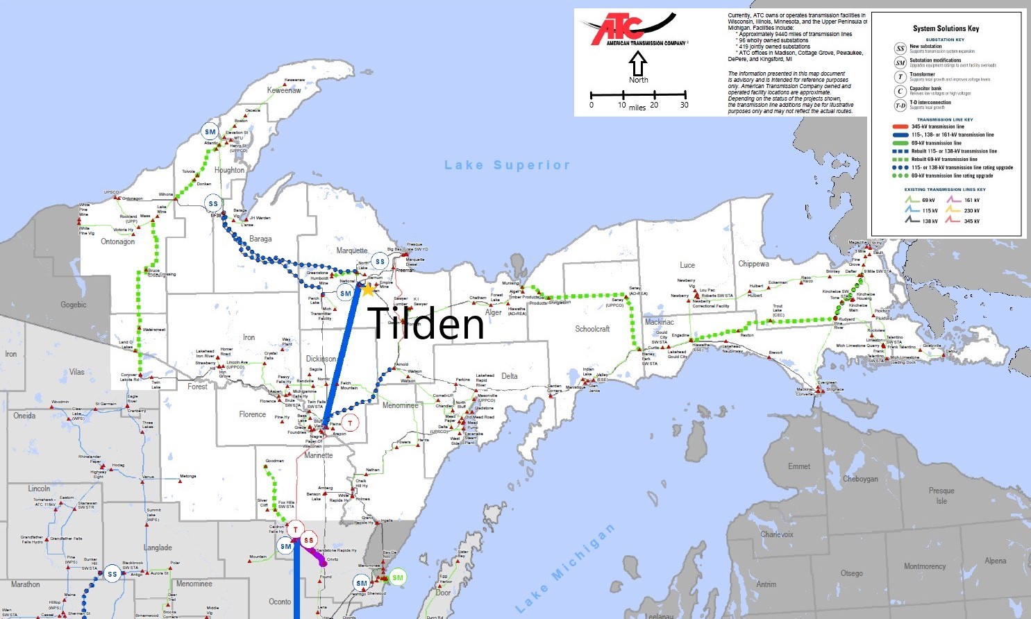
•Power is supplied by Upper Michigan Energy Resources (UMERC) that supplies power through the existing power grid, which is interconnected to neighboring states and is received at its substation on transmission lines owned by American Transmission Company.
•Backup diesel-powered generators are installed at several locations to operate critical equipment should main power be lost.
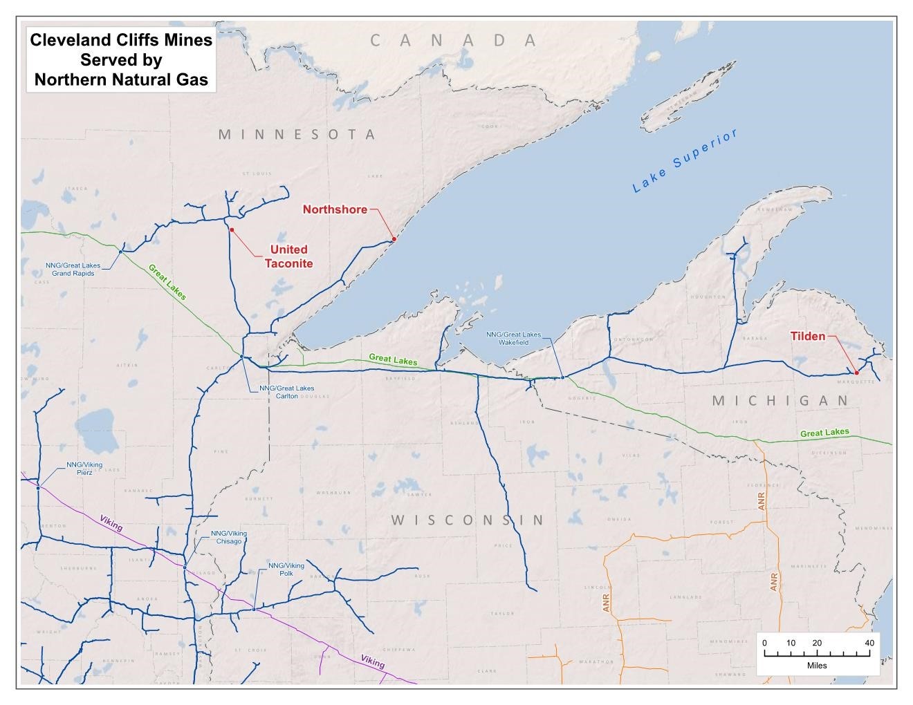
•Natural gas is primarily used for firing the rotary kilns at the pelletizing plant and water boilers in the concentrator. Natural gas is purchased from Encore Energy and supplied to the site via a gas pipeline owned and operated by Northern Natural Gas (NNG), which has an extensive interstate pipeline system.
•The Tilden pellet plant kilns are a dual fuel system with the ability to operate on pulverized coal, natural gas, or a combination of both.
•U.S. Oil supplies the Tilden Mine from its terminal in Green Bay, Wisconsin. The Mine has one 20,000 gal, above-ground diesel fuel tank and one 10,000 gal, underground gasoline storage tank.
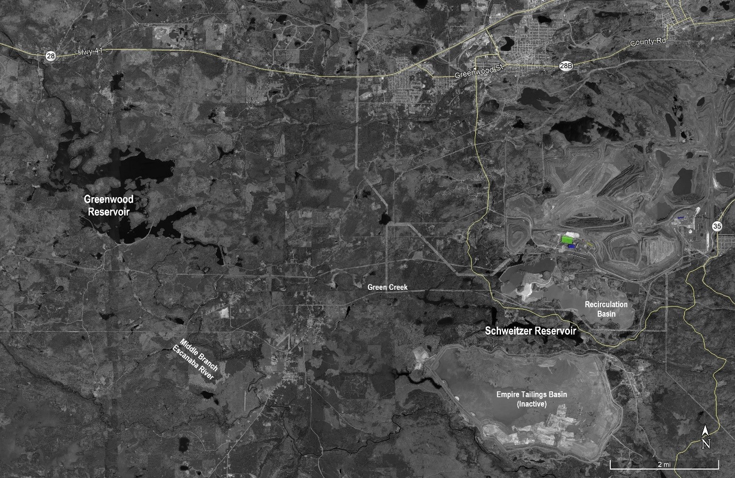
•Fresh make-up water for the process is supplied from the Greenwood Reservoir, which is located approximately seven miles southwest of Ishpeming and is on the Middle Branch Escanaba River.
•Process water is primarily supplied by tailings reclaim.
•Potable water is supplied by two deep well pumps located on site.
•Paved roads and highways.
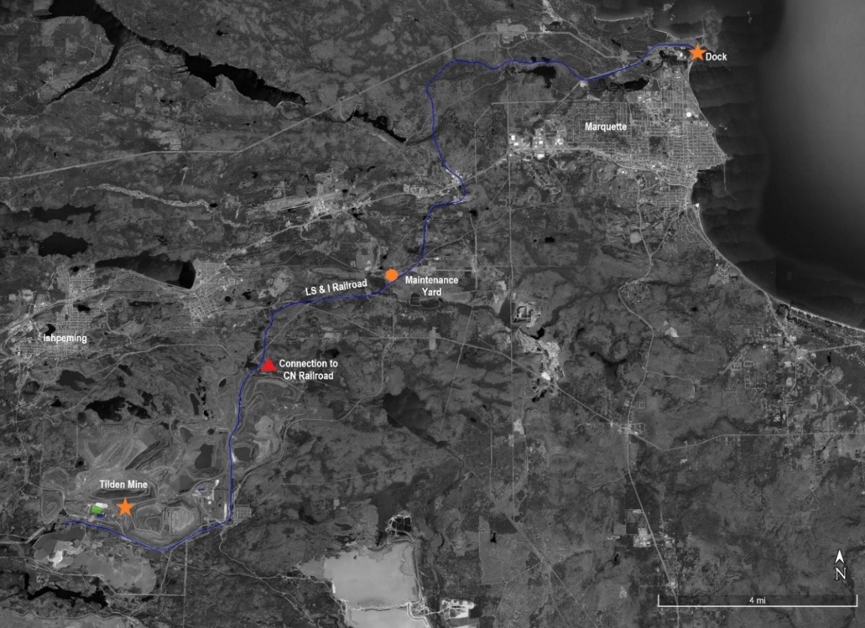
•Pellets produced at the site are shipped in rail cars by the Lake Superior & Ishpeming Railroad (LS&I), a wholly owned subsidiary of Cliffs, 22 mi to the LS&I dock in Marquette, Michigan.
•Tailings are stored in the GTB located approximately five miles southeast of the Tilden concentrator plant and nine miles from Lake Superior. The GTB is comprised of two ring dike-type impoundments: the GNTB, which encompasses approximately 1,350 acres, and the GSTB, which encompasses approximately 1,100 acres.
•Dock facilities in Marquette include 50,000 LT of pellet storage and ship loaders for loading 60,000 LT-capacity lakers that transport pellets to steel mills on the Great Lakes.
•Pellets can also be shipped using the Canadian National (CN) railroad. The CN owns and operates its own rail fleet. Currently, one customer receives direct rail deliveries by CN to Sault Ste. Marie, Ontario, Canada, a distance of 120 mi from the Property.
•Accommodations for employees.
•Local and State infrastructure also includes hospitals, schools, airports, equipment suppliers, fuel suppliers, commercial laboratories, and communication systems.
Cleveland-Cliffs Inc. | Tilden Property, SLR Project No: 138.02467.00001
Technical Report Summary - February 7, 2022 14
1.3.11Market Studies
Cliffs is the largest producer of iron ore pellets in North America. It is also the largest flat-rolled steel producer in North America. In 2020, Cliffs acquired two major steelmakers, ArcelorMittal USA (AMUSA), and AK Steel (AK), vertically integrating its legacy iron ore business with steel production and emphasis on the automotive end market.
Cliffs owns or co-owns five active iron ore mines in Minnesota and Michigan. Through the two acquisitions and transformation into a vertically integrated business, the iron ore mines are primarily now a critical source of feedstock for Cliffs’ downstream primary steelmaking operations. Based on its ownership in these mines, Cliffs’ share of annual rated iron ore production capacity is approximately 28.0 million LT, enough to supply its steelmaking operations and not have to rely on outside supply.
The importance of the steel industry in North America and specifically the USA is apparent by the actions of the US federal government in implementing and keeping import restrictions in place. It is important for middle-class job generation and the efficiency of the national supply chain. It is also an industry that supports the country’s national security by providing products used for US military forces and national infrastructure. Cliffs expects the US government to continue recognizing the importance of this industry and does not see major declines in the production of steel in North America.
Tilden L.C. ships flux pellets annually to Cliffs’ steelmaking facilities in the Midwestern USA, with some quantities shipped by rail to external customers.
For cash flow projections, Cliffs uses a blended pellet revenue rate of $98/WLT Free on Board (FOB) Mine based on a three-year trailing average for 2017 to 2019. Based on macroeconomic trends, SLR is of the opinion that Cliffs’ pellet prices will remain at least at the current three-year trailing average of $98/WLT or above for the next five years.
1.3.12Environmental Studies, Permitting and Plans, Negotiations, or Agreements with Local Individuals or Groups
Tilden L.C. indicated that it presently has the requisite operating permits for the Mine and Plant and estimates that the mine life will be 25 years. Environmental monitoring during operations includes water and air quality monitoring. Closure plans and other post-mining plans are required to be prepared within two years of anticipated closure. Cliffs indicated that it conducts an in-depth review every three years to ensure that the Asset Retirement Obligation (ARO) legal liabilities are accurately estimated based on current laws, regulations, facility conditions, and cost to perform services. These cost estimates are conducted in accordance with the Financial Accounting Standards Board (FASB) Accounting Standards Codification (ASC) 410. SLR is not aware of any formal commitments to local procurement and hiring; however, Cliffs indicated that it has a long-standing relationship with local vendors.
1.3.13Capital and Operating Cost Estimates
Productive and sustaining capital expenditure estimates for the remaining life of the operation are presented in Table 1-7. The LOM capital cost forecast is shown for the next five-year period from 2022 to 2026, which totals $314.2 million and an additional $579.9 million from 2027 to the last year of mining in 2046. Total capital expenditures are estimated at $894.2 million.
Cleveland-Cliffs Inc. | Tilden Property, SLR Project No: 138.02467.00001
Technical Report Summary - February 7, 2022 15
Table 1-7: LOM Capital Costs
Cleveland-Cliffs Inc. – Tilden Property
| | | | | | | | | | | | | | | | | | | | | | | | | | |
| Type | Values | Total | 2022 | 2023 | 2024 | 2025 | 2026 | 2027-2046 |
| Total | $ millions | 894.2 | 63.5 | 82.9 | 45.7 | 43.8 | 78.3 | 579.9 |
Operating costs are based on a full run rate of flux pellets consistent with what is expected for the life of the mine. A LOM average operating cost of $66.00/WLT pellet is estimated over the remaining 25 years of the mine life and is presented by area in Table 1-8.
Table 1-8: LOM Operating Costs
Cleveland-Cliffs Inc. – Tilden Property
| | | | | |
| Description | LOM
($/WLT Pellet) |
| Mining | 15.30 |
| Processing | 42.79 |
| Site Administration | 2.84 |
| General/Other | 5.07 |
| Operating Cash Cost | 66.00 |
Cliffs’ capital and operating costs estimates are derived from annual budgets and historical actuals over the long life of the current operation. According to the American Association of Cost Engineers (AACE) International, these estimates would be classified as Class 1 with an accuracy range of -3% to -10% to +3% to +15%.
Cleveland-Cliffs Inc. | Tilden Property, SLR Project No: 138.02467.00001
Technical Report Summary - February 7, 2022 16
2.0INTRODUCTION
SLR International Corporation (SLR) was retained by Cleveland-Cliffs Inc. (Cliffs) to prepare an independent Technical Report Summary (TRS) for the Tilden Property (Tilden or the Property), located in Northern Michigan, USA. The owner of the Property, Tilden Mining Company L.C. (Tilden L.C.), is a wholly owned subsidiary of Cliffs.
The purpose of this TRS is to disclose year end (YE) 2021 Mineral Resource and Mineral Reserve estimates for Tilden.
Cliffs is listed on the New York Stock Exchange (NYSE) and currently reports Mineral Reserves of pelletized ore in SEC filings. This TRS conforms to the United States Securities and Exchange Commission’s (SEC) Modernized Property Disclosure Requirements for Mining Registrants as described in Subpart 229.1300 of Regulation S-K, Disclosure by Registrants Engaged in Mining Operations (S-K 1300) and Item 601 (b)(96) Technical Report Summary.
The Property includes the Tilden Mine (the Mine) and processing facility (the Plant) located approximately five miles south of the city of Ishpeming, Michigan. The Property is also immediately west of Cliffs’ Empire Property, which was indefinitely idled in 2016. The Mine is a large, operating, open-pit iron mine and is unique among Cliffs’ US-owned operations because the primary ore mineral at Tilden is hematite, with other minerals being martite (oxidized pseudomorph of magnetite), goethite, and siderite (iron carbonate mineral), as opposed to strictly magnetite. The Property is also unique in the world in that the hematite-dominant ore is mined at a low grade, concentrated using a selective-flocculation desliming and flotation process, and pelletized.
The Property commenced operations in 1974 under a partnership of Algoma Steel, Stelco, J&L Steel, Wheeling-Pittsburgh Steel, Sharon Steel, and The Cleveland-Cliffs Iron Company (CCIC). The property has since been at least partially in the possession of a subsidiary of Cliffs. In 2001, Cliffs acquired Algoma Steel's 45% interest in Tilden L.C. In 2017, Cliffs became the sole owner of Tilden L.C.
The open-pit operation has a mining rate of approximately 21 million long tons (MLT) of ore per year and produces 7.7 MLT of iron ore pellets per year, which are mostly shipped by freighter via the Great Lakes to Cliffs’ steel mill facilities in the Midwestern USA, with some quantities shipped by rail to external customers.
2.1Site Visits
SLR Qualified Persons (QPs) visited the Property on October 24, 2019 and January 20 to 24, 2020. During the 2019 site visit, the SLR team all toured the tailings basin, plant laboratory, concentrator and pelletizing facilities plus rail pellet loadout site, and the mine offices and operational areas.
During the 2020 site visit, the SLR geologist visited the mine offices and worked with the mine geologists to update the geological and Mineral Resource block model.
2.2Sources of Information
Technical documents and reports on the Property were obtained from Cliffs’ personnel. During the preparation of this TRS, discussions were held with personnel from Cliffs:
•Kurt Gitzlaff, Director - Mine Engineering, Cliffs Technical Group (CTG)
•Michael Orobona, Principal Geologist, CTG
Cleveland-Cliffs Inc. | Tilden Property, SLR Project No: 138.02467.00001
Technical Report Summary - February 7, 2022 17
•Michael Koop, Lead Mine Engineer, CTG
•Scott Gischia, Director - Environmental Compliance
•Dean Korri, Director - Basin & Civil Engineering
•Sandy Karnowski, District Manager - Public Affairs
•John Elton, Senior Director - Corporate Accounting & Assistant Controller
•Tushar Mondhe, Senior Manager – Operations and Capital Finance
•Al Strandlie, Mine Geologist
•Tyson Murphy, Section Manager - Mine Engineering
•Todd Davis, Area Manager – Plant
•Kris Scherer, Tailings Engineer
•Brent Ketzenberger, Environmental Manager
This TRS was prepared by SLR QPs. The documentation reviewed, and other sources of information, are listed at the end of this TRS in Section 24.0, References.
Cleveland-Cliffs Inc. | Tilden Property, SLR Project No: 138.02467.00001
Technical Report Summary - February 7, 2022 18
2.3List of Abbreviations
The U.S. System for weights and units has been used throughout this report. Tons are reported in long tons (LT) of 2,240 lb unless otherwise noted. All currency in this report is US dollars (US$ or $) unless otherwise noted. Abbreviations and acronyms used in this TRS are listed below.
| | | | | | | | | | | |
| Unit Abbreviation | Definition | Unit Abbreviation | Definition |
| a | annum | LT/h | long tons per hour |
| A | ampere | µL | microliter |
| acfm | actual cubic feet per minute | M | mega (million); molar |
| bbl | barrels | Ma | one million years |
| Btu | British thermal units | MBtu | thousand British thermal units |
| d | day | MCF | million cubic feet |
°F | degree Fahrenheit | MCF/h | million cubic feet per hour |
| fasl | feet above sea level | mi | mile |
| ft | foot | min | minute |
ft2 | square foot | MLT/y | million long tons per year |
ft3 | cubic foot | MPa | megapascal |
| ft/s | foot per second | mph | miles per hour |
| g | gram | MVA | megavolt-amperes |
| G | giga (billion) | MW | megawatt |
| Ga | one billion years | MWh | megawatt-hour |
| gal | gallon | MWLT | million wet long tons |
| gal/d | gallon per day | oz | Troy ounce (31.1035g) |
| g/L | gram per liter | oz/ton | ounce per short ton |
| g/y | gallon per year | ppb | part per billion |
| gpm | gallons per minute | ppm | part per million |
| hp | horsepower | psia | pound per square inch absolute |
| h | hour | psig | pound per square inch gauge |
| Hz | hertz | rpm | revolutions per minute |
| in. | inch | RL | relative elevation |
in2 | square inch | s | second |
| J | joule | ton | short ton |
| kLT | thousand long tons | stpa | short ton per year |
| k | kilo (thousand) | stpd | short ton per day |
kg/m3 | Kilogram per cubic meter | t | metric tonne |
| kVA | kilovolt-amperes | US$ | United States dollar |
| kW | kilowatt | V | volt |
| kWh | kilowatt-hour | W | watt |
| kWLT | thousand wet long tons | wt% | weight percent |
| L | liter | WLT | wet long ton |
| lb | pound | w/w | weight by weight |
| LT | long or gross ton equivalent to 2,240 pounds | y | year |
| LT/d | long tons per day | yd3 | cubic yard |
Cleveland-Cliffs Inc. | Tilden Property, SLR Project No: 138.02467.00001
Technical Report Summary - February 7, 2022 19
| | | | | |
| Acronym | Definition |
| AACE | American Association of Cost Engineers |
| AK | AK Steel |
| AMUSA | ArcelorMittal USA |
| ANSI | American National Standards Institute |
| ARO | asset retirement obligation |
| ASC | Accounting Standards Codification |
| ASQ | American Society for Quality |
| ASTM | American Society for Testing and Materials |
| BF | blast furnace |
| BFA | bench face angle |
| BH | bench height |
| BIF | banded iron formation |
| BLS | United States Bureau of Labor Statistics |
| CCD | counter-current decantation |
| CCIC | Cleveland-Cliffs Iron Company |
| CCP | Conceptual Closure Plan |
| CERCLA | Comprehensive Environmental Response, Compensation, and Liability Act |
| CFR | Cost and Freight |
| CN | Canadian National Railroad |
| COA | certificates of analysis |
| CRIRSCO | Committee for Mineral Reserves International Reporting Standards |
| D&A | depreciation and amortization |
| DDH | diamond drill hole |
| DMO | Department Maintenance Office |
| DOSS | Dioctyl Sulfosuccinate |
| DRI | direct reduced iron |
| DSO | direct-shipping iron ore |
| EAF | electric arc furnace |
| EAP | Emergency Action Plan |
| EGLE | Michigan Department of Environment, Great Lakes and Energy |
| EIS | Environmental Impact Statement |
| EMP | Environmental Management Plan |
| EMS | environmental management system |
| EPA | United States Environmental Protection Agency |
| ESOP | Environmental Standard Operating Procedures |
| EOR | Engineer of Record |
| FASB | Financial Accounting Standards Board |
| FDCP | Fugitive Dust Control Plan |
| FOB | Free on Board |
| GHG | greenhouse gas |
| GIM | Geoscientific Information Management |
| GNTB | Gribben North Tailings Basin |
| GPS | global positioning system |
Cleveland-Cliffs Inc. | Tilden Property, SLR Project No: 138.02467.00001
Technical Report Summary - February 7, 2022 20
| | | | | |
| Acronym | Definition |
| GSI | Geological Strength Index |
| GSSI | General Security Services Corporation |
| GSTB | Gribben South Tailings Basin |
| GTB | Gribben Tailings Basin |
| HBI | hot briquetted iron |
| HRC | hot-rolled coil |
ID2 | Inverse distance squared |
ID3 | Inverse distance cubed |
| IF | iron formation |
| IRA | Inter-ramp angle |
| IRR | internal rate of return |
| ISO | International Standards Organization |
| KEV | key economic variables |
| LG | Lerchs-Grossmann |
| LiDAR | light imaging, detection, and ranging |
| LMF | Laurentian Mixed Forest |
| LOM | life of mine |
| LS&I | Lake Superior & Ishpeming Railroad |
| MAC | Mining Association of Canada |
| MLT | million long tons |
| MR | moving range |
| MRCC | Midwestern Regional Climate Center |
| NAAQS | National Ambient Air Quality Standards |
| NAD | North American Datum |
| NESHAP | National Emission Standards for Hazardous Air Pollutants |
| NGO | non-governmental organization |
| NN | nearest neighbor |
| NNG | Northern Natural Gas |
| NOAA | National Oceanic and Atmospheric Administration |
| NOLA | Nuclear On-Line Analyzer |
| NPDES | National Pollution Discharge Elimination System |
| NPV | net present value |
| OMS | Operations, Maintenance, and Surveillance |
| OSA | overall slope angle |
| QA/QC | quality assurance/quality control |
| QP | Qualified Person |
| RC | rotary circulation drilling |
| RCRA | Resource Conservation and Recovery Act |
| ROM | run of mine |
| RQD | rock quality designation |
| RTR | risk and technology review |
| SDS | State Disposal System Permit |
| SEC | United States Securities and Exchange Commission |
Cleveland-Cliffs Inc. | Tilden Property, SLR Project No: 138.02467.00001
Technical Report Summary - February 7, 2022 21
| | | | | |
| Acronym | Definition |
| SG | specific gravity |
| SMU | selective mining unit |
| SQL | Structured Query Language |
| SPC | Statistical Process Control |
| SPT | standard penetration testing |
| TMDL | total maximum daily load |
| TRS | Technical Report Summary |
| TSF | tailings storage facility |
| TSP | total suspended particulates |
| UCS | uniaxial compressive strength |
| UMERC | Upper Michigan Energy Resources |
| USGAAP | United States General Accepted Accounting Principles |
| USGS | United States Geological Survey |
| USNRC | United States Nuclear Regulatory Commission |
| WTF | water treatment facility |
| XRF | x-ray fluorescence |
Cleveland-Cliffs Inc. | Tilden Property, SLR Project No: 138.02467.00001
Technical Report Summary - February 7, 2022 22
3.0PROPERTY DESCRIPTION
3.1Property Location
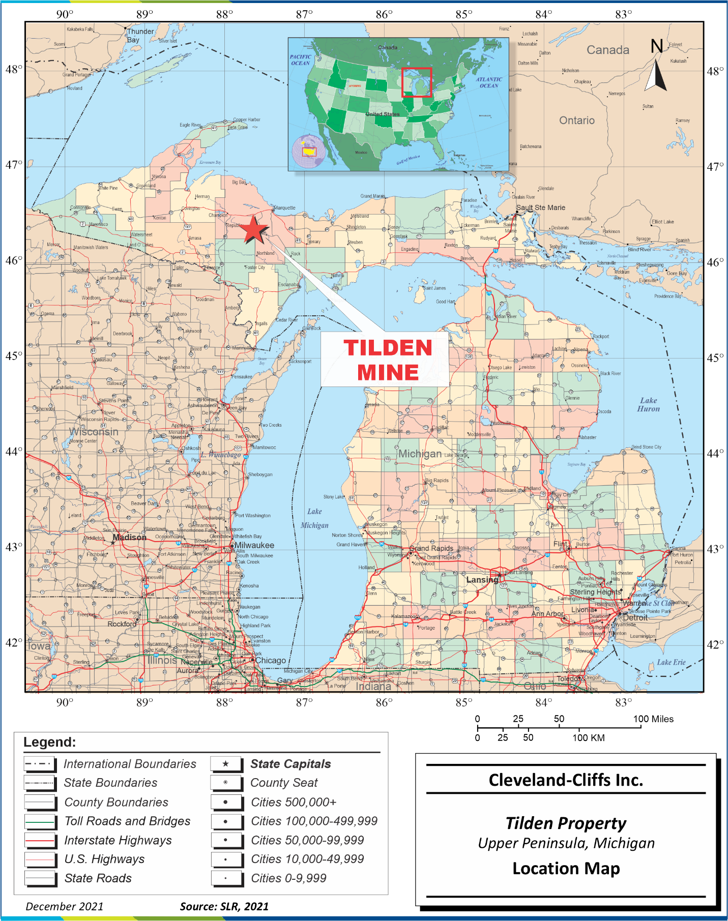
The Property is located in Marquette County, in Michigan’s Upper Peninsula, USA, on the Marquette Iron Range, approximately five miles south of the city of Ishpeming at latitude 46° 27' N and longitude 87° 39' W. The Property is also immediately adjacent to Cliffs’ indefinitely idled Empire Mine and processing facility. Figure 3-1 shows the location of the Property.
3.2Land Tenure
3.2.1Mineral Titles
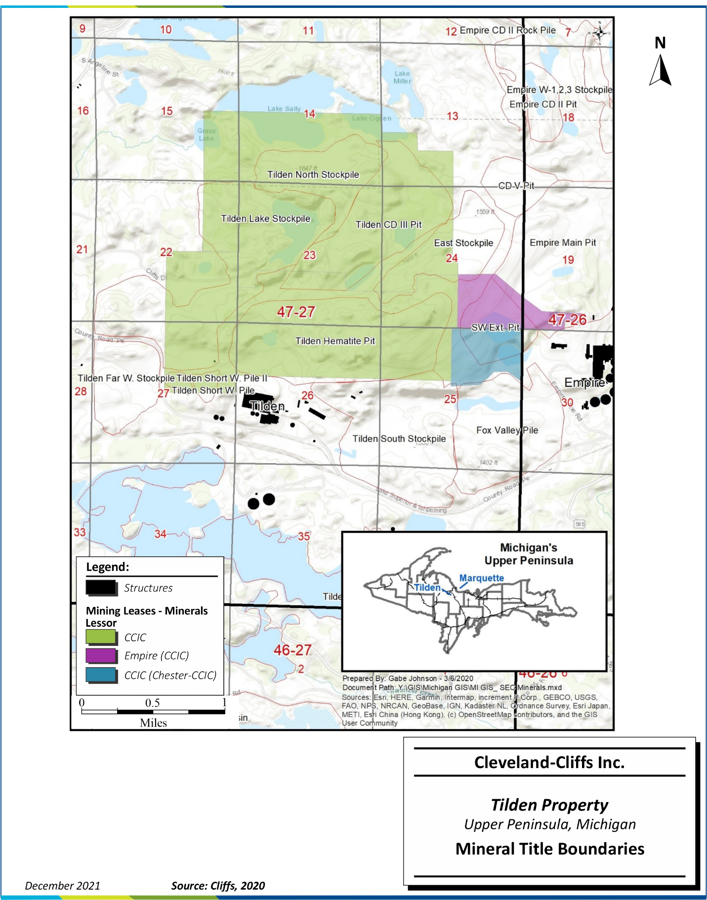
Land ownership and mineral leases are held by Tilden L.C., which is a wholly owned subsidiary of Cliffs. Initial acquisitions from outside parties were accomplished by CCIC over 150 years ago and moved to the various partnerships before Tilden L.C. was established.
The Property consists of approximately 2,470 acres of mineral leases from three parties. Tilden leases approximately 2,210 acres directly from its affiliate, CCIC. Tilden subleases approximately 140 acres from Empire Iron Mining Partnership, another affiliate which leases the Property from CCIC. Tilden subleases the remaining, approximately 120 acres from CCIC, which leases the Property from the Chester Company (2/3 undivided interest) and CCIC (1/3 undivided interest), as illustrated in Figure 3-2. Mineral leases include surface mining rights. Land tenure is summarized in Table 3-1.
Both Tilden subleases expire in 2061; the CCIC lease is through the life of mine (LOM). In order to maintain the mineral leases until their expiration, Tilden L.C. must continue to make minimum prepaid royalty payments each quarter and pay property taxes. When mining occurs, a royalty is due per long ton of crude ore mined or long ton of pellets produced from the crude ore mined, and payable to the respective lessors quarterly. Royalty rates per long ton fluctuate based on industry and economic indexes. Minimum prepaid royalty payments may be credited against royalties due when mining occurs. Specific terms and provisions of the mineral leases are confidential.
Cleveland-Cliffs Inc. | Tilden Property, SLR Project No: 138.02467.00001
Technical Report Summary - February 7, 2022 23
Figure 3-1: Location Map
Cleveland-Cliffs Inc. | Tilden Property, SLR Project No: 138.02467.00001
Technical Report Summary - February 7, 2022 24
Figure 3-2: Mineral Title Boundaries
Cleveland-Cliffs Inc. | Tilden Property, SLR Project No: 138.02467.00001
Technical Report Summary - February 7, 2022 25
Table 3-1: Land Tenure
Cleveland-Cliffs Inc. – Tilden Property
| | | | | |
| Lease Name | Expiration Date |
| Empire Mining Sublease | 6/1/2061 |
| CCIC Mining Sublease | 6/1/2061 |
| CCIC Supplemental Lease | 12/31/2070 |
3.2.2Surface Rights
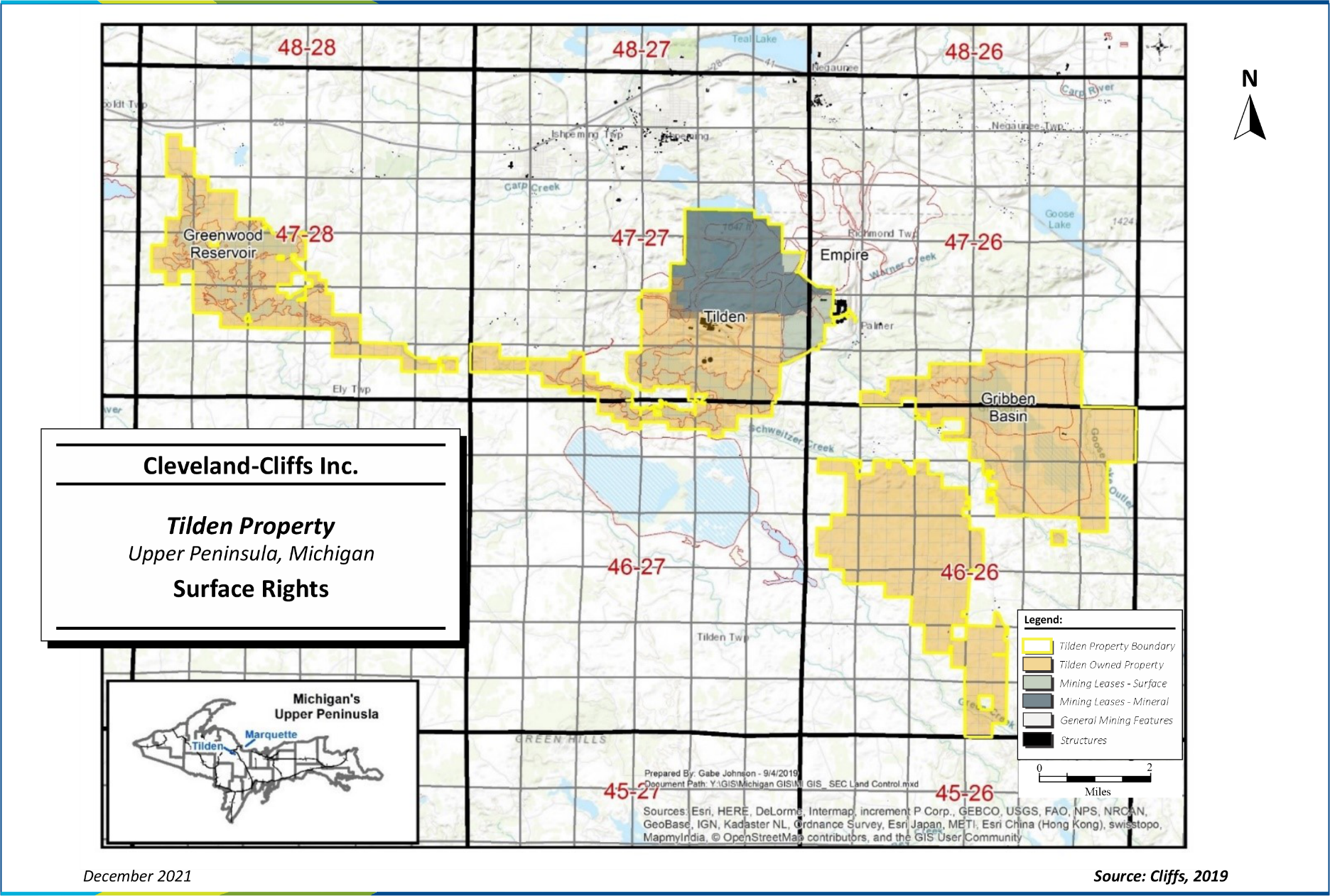
Surface rights consist of approximately 21,100 acres of owned property in and around the Mine, Plant, Greenwood Reservoir, and the Gribben Basin, as illustrated in Figure 3-3. To maintain ownership, property taxes must be paid to the local government units in Marquette County.
Cleveland-Cliffs Inc. | Tilden Property, SLR Project No: 138.02467.00001
Technical Report Summary - February 7, 2022 26
Figure 3-3: Surface Rights
Cleveland-Cliffs Inc. | Tilden Property, SLR Project No: 138.02467.00001
Technical Report Summary - February 7, 2022 27
3.3Encumbrances
Tilden grants leases, licenses, and easements for various purposes including miscellaneous community land uses, utility infrastructure, and other third-party uses that encumber the Property but do not materially inhibit operations. Certain assets of Tilden L.C. serve as collateral as part of Cliffs’ asset-based lending (ABL) facility. Cliffs has outstanding standby letters of credit, which were issued to back certain obligations of Tilden L.C., including certain permits and tailings basin projects. Additionally, Tilden has and may continue to enter into lease agreements for necessary equipment used in the operations of the mine.
3.4Royalties
Reference section 3.2 for royalty information. No overriding royalty agreements are in place.
3.5Other Significant Factors and Risks
No additional significant factors or risks are known.
SLR is not aware of any environmental liabilities on the Property. Cleveland-Cliffs Inc. has all required permits to conduct the proposed work on the Property. SLR is not aware of any other significant factors and risks that may affect access, title, or the right or ability to perform the proposed work program on the Property.
Cleveland-Cliffs Inc. | Tilden Property, SLR Project No: 138.02467.00001
Technical Report Summary - February 7, 2022 28
4.0ACCESSIBILITY, CLIMATE, LOCAL RESOURCES, INFRASTRUCTURE AND PHYSIOGRAPHY
4.1Accessibility
The Property is located close to the cities of Marquette, Negaunee, and Ishpeming, Michigan. The Mine can be accessed by the Tilden entrance gate near the community of National Mine, located two miles south of Ishpeming on County Road 476. Alternatively, the Property can be accessed from the east through the adjacent Empire Mine. The Empire entrance gate is located on M-35, nine miles south of US Highway 41 between Marquette and Negaunee. Sawyer International Airport, the closest public airport, is located 17 mi south of Marquette and serves the region with several flights daily to major hubs in Minneapolis, Chicago, and Detroit.
4.2Climate
Michigan’s Upper Peninsula has a humid continental climate, typified by large seasonal temperature differences. Summers are generally warm and humid; winters are cold and long. Precipitation in the area averages approximately 31 in. of rain and 102 in. of snow in the winter (Western Regional Climate Center, 2015). The average maximum and minimum temperatures are shown in Table 4-1, along with the average precipitation and snowfall. Snowfall in the region is greatly influenced by the “lake effect” due to proximity to the Great Lakes. Many towns in the Upper Peninsula have recorded annual snowfalls in excess of 350 in., and storms can quickly reach whiteout conditions and last for days (Albert, 1995).
The Property is a year-round operation and is not generally curtailed due to seasonal temperature changes or weather conditions.
Table 4-1: Ishpeming, MI Temperature and Precipitation
Cleveland-Cliffs Inc. – Tilden Property
| | | | | | | | | | | | | | | | | | | | | | | | | | | | | | | | | | | | | | | | | |
| Station 204127 | Jan | Feb | Mar | Apr | May | Jun | Jul | Aug | Sep | Oct | Nov | Dec | Annual |
Average Max. Temperature (oF) | 23.2 | 29.6 | 38.5 | 52.9 | 66.0 | 73.8 | 79.6 | 76.1 | 65.8 | 53.9 | 38.0 | 26.6 | 52.2 |
Average Min. Temperature (oF) | 5.2 | 10.5 | 17.7 | 29.2 | 40.0 | 48.0 | 54.4 | 52.8 | 44.8 | 35.3 | 23.2 | 11.4 | 31.1 |
| Average Total Precipitation (in.) | 1.5 | 1.3 | 2.0 | 2.7 | 2.7 | 3.0 | 3.4 | 3.5 | 3.7 | 3.7 | 2.3 | 1.9 | 31.4 |
| Average Total Snow Fall (in.) | 20.0 | 17.6 | 16.6 | 8.2 | 1.2 | 0.1 | 0.0 | 0.0 | 0.2 | 3.8 | 15.4 | 19.1 | 102.1 |
| Average Snow Depth (in.) | 15.0 | 21.0 | 16.0 | 3.0 | 0.0 | 0.0 | 0.0 | 0.0 | 0.0 | 0.0 | 2.0 | 8.0 | 5.0 |
4.3Local Resources
Local and State infrastructure includes hospitals, schools, airports, equipment suppliers, fuel suppliers, and communication systems. The Property is located approximately five miles south of the city of Ishpeming, Michigan, nine miles southwest of Negaunee, Michigan, and 20 mi west-southwest of
Cleveland-Cliffs Inc. | Tilden Property, SLR Project No: 138.02467.00001
Technical Report Summary - February 7, 2022 29
Marquette, Michigan. Medical facilities with trauma centers are located in the cities of Marquette and Green Bay. Table 4-2 is a list of the major population centers and the distance by road to the Property.
Table 4-2: Nearby Population Centers
Cleveland-Cliffs Inc. – Tilden Property
| | | | | | | | | | | |
| City/Town | Medical Center | Population 2010 Census | Mileage to Mine |
| Palmer, MI | n/a | 449 | 3.5 |
| Ishpeming, MI | ER | 6,470 | 5.0 |
| Negaunee, MI | n/a | 4,568 | 9.0 |
| Marquette, MI | Level II | 21,355 | 20.0 |
| Green Bay, WI | Level II and III | 104,057 | 167 |
Source: U.S. Census Bureau, Google Maps
The Tilden operation employs a total of 967 salaried and hourly employees, including Lake Superior & Ishpeming Railroad (LS&I) railroad staff, as of Q4 2021. The majority of the employees live within a 50 mi radius of the Property.
4.4Infrastructure
The Property is located in a historically important, iron-producing region in Northern Michigan. All infrastructure necessary to mine and process significant commercial quantities of iron ore exist at the current time. Infrastructure items include administration buildings and offices, maintenance shops, high-voltage electrical supplies, natural gas pipelines that connect into the North American distribution system, concentrator, pelletizing plant, water sources, paved roads and highways, railroads for transporting raw materials and final product, port facilities that connect into the Great Lakes, and towns where employees live. Additional details regarding Tilden infrastructure are provided in Section 15.0 of this TRS.
4.5Physiography
The Property is within the limits of a topographic region known as the Superior Uplands, a part of the Canadian Shield. This region is more rugged than the eastern portion of the Upper Peninsula, as it is dominated by Precambrian volcanic rocks and Archean basement rocks that were eroded down over many glaciation events. The Tilden Mine property features elevations ranging from approximately 1,300 fasl to 1,800 fasl. Topography is hilly and is dominated by glacially influenced landforms. Tilden is located in the Western Upper Peninsula Ecoregion (Section IX) and characterized by a landscape featuring moraines, drumlins, lake plains, outwash channels, outwash plains, and glacially eroded bedrock ridges (Albert, 1995).
Vegetation in the vicinity of Tilden is described as northern hardwood forest dominated by sugar maple, eastern hemlock, basswood, yellow birch, and sparse white pine. The Western Upper Peninsula Ecoregion also contains numerous bogs, tamarack-black spruce swamps, and hardwood-conifer swamps. The bogs and wetlands include elm, green and black ash, and red and sugar maple. Upland wetlands (remnants of glacial lakebeds) support ash, red maple, pin oak, and swamp white oak, whereas acidic,
Cleveland-Cliffs Inc. | Tilden Property, SLR Project No: 138.02467.00001
Technical Report Summary - February 7, 2022 30
boggy sites may contain boreal flora that persist in this area as outliers of the Canadian forest, including black spruce, larch (tamarack), red maple, several evergreen shrubs, and locally rare herbaceous plants that may grow on a mat of partially decomposed sphagnum moss (Sommers, 1984).
The soil profile in this part of Michigan’s Upper Peninsula is dominated by spodosols and histosols. Spodosols are formed in sandy material where precipitation is sufficient to allow large amounts of water to infiltrate the soil multiple times per year. In Michigan, the spring snowmelt season produces these types of conditions. Spodosols in Northern Michigan typically form under mixed forests of maple, pine, hemlock, and birch. Because of the sandy nature of the soil, they have limited water storage capacity and are generally poor for farming. They also locally have varying horizons that may feature abundant organic matter, and aluminum and iron concentrations. Histosols are comprised mainly of organic materials and form in low wetlands or bogs with reducing conditions that allow organic material to accumulate over a longer time period as compared to spodosols (Schaetzl and Anderson, 2005).
Cleveland-Cliffs Inc. | Tilden Property, SLR Project No: 138.02467.00001
Technical Report Summary - February 7, 2022 31
5.0HISTORY
5.1Prior Ownership
The Tilden Mine officially began operation in 1974 under a partnership of Algoma Steel, Stelco, J&L Steel, Wheeling-Pittsburgh Steel, Sharon Steel, and CCIC. The Property has since been at least partially in the possession of a subsidiary of Cliffs. Notable predecessors to the current evolution of the company were the Cleveland Iron Mining Company and the Iron Cliffs Company. The latter was formed in 1865 by Samuel J. Tilden, a financier who would become the governor of New York and a contender in the 1876 presidential election.
In November 2001, Cliffs announced the planned acquisition of Algoma Steel's 45% interest in the Tilden Mine. In January 2003, Cliffs increased its ownership of the adjacent Empire Mine to 79%, which led to the combination of the Empire and Tilden mining operations before the end of that year.
On August 27, 2007, U.S. Steel purchased Stelco and with it a 15% interest in Tilden L.C. In 2017, Cliffs purchased U.S. Steel’s interest, making Cliffs the sole owner of Tilden L.C.
5.2Exploration and Development History
Iron deposits in Northern Michigan were originally described in the early 1840s by Douglass Houghton, Michigan’s first State Geologist. Houghton stated that iron deposits of unknown extent were to be found near the south shore of Lake Superior. In 1844, United States Deputy Surveyor William Austin Burt observed unusual variations in his compass, which tended to behave strangely in the vicinity of certain outcrops that would later be identified as a hematite-rich banded iron formation (BIF). The first major discovery of high-grade iron oxides was in early 1845 near the present site of Negaunee, Michigan (Stiffler, 2010). The Jackson Mining Company was formed shortly thereafter in July 1845, and iron mining in Michigan officially began. The Cleveland Iron Company was formed in 1847 and began exploration for iron ores just east of Ishpeming, Michigan. In 1850, the company changed its name to the Cleveland Iron Mining Company and was granted a charter for mining, smelting, and manufacturing ores, minerals, and metals. The Iron Cliffs Company formed in 1865 and began operations at the Barnum Mine in 1867. By 1871, the Iron Cliffs Company owned a number of small, direct-ship iron mines, including a mine referred to as the Tilden. There is little information regarding the original Tilden Mine, which was focused on direct-ship ores.
Ores were shipped via the Sault Ste. Marie Ship Canal to furnaces on the lower Great Lakes starting in 1855, and tonnages gradually increased into the latter part of the 19th century. In 1891, the Cleveland-Cliffs Iron Company was founded through a merger of the Cleveland Iron Mining Company and the Iron Cliffs Company. After World War II, the underground, high-grade iron mines were almost depleted. Extensive development of low-grade, open pit mining began, and the first commercial agglomeration (pellet) plant in the Lake Superior region started operations in 1952. Agglomeration was a relatively new process that took the concentrate from lower-grade deposits and produced pelletized product containing approximately 65% Fe. The Tilden Mine opened in 1974 after years of favorable experimental testing for processing of fine-grained hematite ores.
Site-standard analytical procedures of bench-scale flotation and magnetic iron determination by a saturation magnetization analyzer (Satmagan) applied to drill core were developed prior to mining and continue to the present as described in section 8.1 of this TRS.
Cleveland-Cliffs Inc. | Tilden Property, SLR Project No: 138.02467.00001
Technical Report Summary - February 7, 2022 32
Early regional geologic mapping was compiled by the United States Geological Survey (USGS) (Van Hise and Leith, 1911), and more detailed quadrangle geologic mapping was completed in the mid-20th century (Gair, 1975; Simmons, 1974). Aeromagnetic surveys were first completed in the region in the 1960s and documented by the USGS (Case and Gair, 1965). Cliffs and Tilden Mine do not maintain detailed records or results of early, non-drilling prospecting methods used during initial exploration activities (ground geophysical surveys, trenching, test pits, etc.) conducted prior to Cliffs’ development of the operation in the early 1970s.
5.3Historical Mineral Reserve Estimates
As the Property has since been at least partially in the possession of a subsidiary of Cliffs, there are no historical Mineral Resource or Mineral Reserve estimates.
5.4Past Production
The Property has produced pellets since 1974 and currently operates with a plant capacity of 7.7 MLT/y. Production has been hematite flux pellets or hematite/magnetite flux since 1994. Magnetite ores were processed from 1989 to 2009, and after 2009, remaining magnetite ores were processed at the Empire Mine prior to its indefinite idling in 2016. Table 5-1 shows the historical pellet production from the Mine and Plant since 1974.
Table 5-1: Historical Production
Cleveland-Cliffs Inc. – Tilden Property
| | | | | | | | | | | | | | | | | | | | | | | | | | | | | | | | |
| Year | Stripping (kWLT) | Crude Ore (kWLT) | Concentrate (kWLT) | Pellets (kWLT) |
| Hem. | Mag. | Total | Hem. | Mag. | Total | Hem. | Mag. | Total |
| 1974- 1989 | 0 | 198,998 | 6,305 | 205,303 | 81,688 | 1,991 | 83,679 | 72,442 | 1,796 | 74,238 |
| 1990- 1999 | 0 | 97,466 | 59,519 | 156,985 | 40,969 | 20,241 | 61,209 | 36,632 | 21,060 | 57,693 |
| 2000- 2009 | 0 | 139,884 | 40,371 | 180,255 | 59,636 | 15,560 | 75,196 | 55,268 | 15,149 | 70,417 |
| 2010 | 0 | 19,194 | 0 | 19,194 | 7,980 | 0 | 7,980 | 7,468 | 0 | 7,468 |
| 2011 | 0 | 20,850 | 0 | 20,850 | 8,374 | 0 | 8,374 | 7,794 | 0 | 7,794 |
| 2012 | 0 | 21,380 | 0 | 21,380 | 8,567 | 0 | 8,567 | 7,618 | 0 | 7,618 |
| 2013 | 0 | 20,114 | 0 | 20,114 | 7,922 | 0 | 7,922 | 7,485 | 0 | 7,485 |
| 2014 | 0 | 20,298 | 0 | 20,298 | 8,130 | 0 | 8,130 | 7,581 | 0 | 7,581 |
| 2015 | 0 | 19,661 | 0 | 19,661 | 7,998 | 0 | 7,998 | 7,631 | 0 | 7,631 |
| 2016 | 0 | 20,672 | 0 | 20,672 | 8,295 | 0 | 8,295 | 7,632 | 0 | 7,632 |
| 2017 | 0 | 21,007 | 0 | 21,007 | 8,157 | 0 | 8,157 | 7,650 | 0 | 7,650 |
| 2018 | 0 | 21,016 | 0 | 21,016 | 8,320 | 0 | 8,320 | 7,679 | 0 | 7,679 |
| 2019 | 0 | 21,500 | 0 | 21,500 | 8,312 | 0 | 8,312 | 7,708 | 0 | 7,708 |
| 2020 | 0 | 18,006 | 0 | 18,006 | 6,968 | 0 | 6,968 | 6,323 | 0 | 6,323 |
| 2021 | 0 | 21,482 | 0 | 21,482 | 8,238 | 0 | 8,238 | 7,365 | 0 | 7,365 |
| TOTAL | 0 | 681,528 | 106,195 | 787,723 | 279,554 | 37,792 | 317,345 | 254,276 | 38,005 | 292,282 |
Cleveland-Cliffs Inc. | Tilden Property, SLR Project No: 138.02467.00001
Technical Report Summary - February 7, 2022 33
6.0GEOLOGICAL SETTING, MINERALIZATION, AND DEPOSIT
6.1Regional Geology
Essential aspects of the regional geology in the Lake Superior region have been understood since the early 1900s, and the geologic understanding of the area has remained relatively unchanged over the years.
Iron ores produced within the region range from high-grade, structurally controlled “natural” or direct-shipping iron ore (DSO) bodies to more disseminated, stratigraphically controlled, low-grade iron ores that require beneficiation. The beneficiation-grade deposits are found in a sequence of Paleoproterozoic metasedimentary rocks overlying Archean granitic basement in the Lake Superior region.
The Palmer Gneiss represents the basement complex of Archean (2.6 Ga) granitic gneiss underlying a thick sequence of variably metamorphosed volcanic rocks and sedimentary rocks including iron formations hosted within several stratigraphic intervals. The principal iron formations in Northern Michigan are within the 1.9 Ga to 2.7 Ga Marquette Range Supergroup (Figure 6-1).
Paleoproterozoic rocks in the vicinity of Tilden consist of three subgroups: the Chocolay Group, the Menominee Group, and the Baraga Group. The stratigraphic sequence features shelf facies of quartzite and dolomite of the Chocolay Group underlying the Menominee Group of argillaceous rocks and the major iron formations. The Baraga Group is generally described as a volcanogenic unit of considerable thickness and complexity (Bayley and James, 1973). In the area of the Marquette Range, it comprises sequences of turbidite, graywacke, and shale along with minor iron formations. The Baraga Group is roughly equivalent to the upper stratigraphy of the Animikie Group in Minnesota. The Menominee Group is comprised of the basal Ajibik Quartzite, the Siamo Slate, the Negaunee Iron Formation (Negaunee IF), and rift-related mafic intrusive rocks. The Menominee Group contains the 1.875 Ga iron formations of economic significance and is correlative with the Animikie Group on the Mesabi Range of Minnesota (Figure 6-1), which hosts several beneficiation-grade (magnetite “taconite”) mining operations.
The Menominee Group was determined to have been deposited between 1.9 Ga and 2.2 Ga by radiometric age dating (Van Schmus and Woolsey, 1975). Although the Menominee Group is stratigraphically equivalent to the Animikie Group in Minnesota, units differ dramatically from one range to the other in thickness, stratigraphic details, and facies type. Sedimentary rocks were deformed and metamorphosed during the Penokean orogeny, resulting in a wide range of metamorphic mineral assemblages and grades. The Marquette district, including the Tilden Mine, is one of the more geologically complex iron mining districts in the Lake Superior region. Orogenic transpression resulted in a relatively tight, west-plunging syncline of strata in the Chocolay and Menominee Groups (Figure 6‑3). To the north, the syncline is bounded by unconformably underlying rocks older than 2.5 Ga. To the west, the syncline opens to a thick sequence of graywacke and slate within the Baraga Group (Bayley and James, 1973). In the eastern part of the syncline, the Negaunee IF can reach a thickness of 2,500 ft. The region along the fold axis of this syncline is referred to as the Marquette trough.
Regional structures include the Niagara Fault Zone, the collision zone between the Wisconsin Magmatic Terrane, the Superior craton, and the Great Lakes Tectonic Zone, which forms the boundary between Archean granite-greenstone and gneissic terranes (Sims et al., 1992). In the Marquette Range area, deformation along the Great Lakes Tectonic Zone evolved from extension and deposition (Schneider et
Cleveland-Cliffs Inc. | Tilden Property, SLR Project No: 138.02467.00001
Technical Report Summary - February 7, 2022 34
al., 2002). The resulting fault-bounded, shallowly west-plunging, asymmetric syncline contains a series of second-order growth fault basins that define the detailed stratigraphic variations.
Source: Cannon, et al., 2007
Figure 6-1: Fe Formation Locations and Relevant Stratigraphy in the Lake Superior Region
Cleveland-Cliffs Inc. | Tilden Property, SLR Project No: 138.02467.00001
Technical Report Summary - February 7, 2022 35
6.2Local Geology
The Negaunee IF and its equivalents (Figure 6-3) host the majority of the iron deposits in Michigan. In the Marquette Range, the Negaunee IF reaches a thickness of approximately 1,300 ft. The Tilden Mine sits on the southern margin of the Marquette trough and is fault-bounded to the south by Archean gneiss terrane, alternatively referred to as the Palmer Gneiss (Figure 6-2) or the Southern Complex (Figure 6-3). There is no formal subdivision of the Negaunee IF, and stratigraphy is generally discussed in relative terms from the bottom to the top of the unit (Figure 6-2). The majority of the Negaunee IF consists of iron-rich carbonate, carbonate-silicate, or carbonate-oxide facies iron formation (James, 1954; Gair, 1975) roughly described in three zones from lowest to uppermost (Cannon, 1976). The lowest portion is interbedded at its base with the underlying Siamo Slate and consists primarily of laminated chert and siderite. The middle portion is dominated by alternating thin layers of magnetite, iron silicate minerals, and chert. Silicate minerals are dominated by minnesotaite ((Fe2+,Mg)3Si4O10(OH)2), stilpnomelane (K(Fe2+,Mg,Fe3+)8(Si,Al)12(O,OH)27n(H2O)), and quartz (SiO2). The upper Negaunee IF is dominated by increasingly oxidized, hematite-jasper facies (jaspilite) iron formation. It exhibits a texture of thinly interbedded, reddish chert and hematite (Fe2O3) and martite, which is a pseudomorph of hematite occurring after magnetite (Bayley and James, 1973).
Two ages of mafic igneous rocks occur in the Mine: syn-sedimentary sills and associated dikes and a younger dike series of Keweenawan age (approximately 1.0 Ga) that is related to the Midcontinent Rift. The older intrusions vary from fine porphyritic to diabasic or ophitic in composition and texture and typically display chlorite-carbonate alteration assemblages, particularly in deformation zones. The iron formation is variably altered along all intrusive contacts, with the type and extent of alteration dependent on the thickness of the intrusive and the composition of the iron formation (Lukey et al., 2007).
Local structure is characterized by second-order, steeply inclined anticlines and synclines with shallow northwest and southwest plunges. Major structures include the large-scale (hundreds of feet) Main Pit anticline and a fault that marks the contact between Archean gneiss terrane and the iron formation. The fold is asymmetric, with the southern limb steeper than the northern limb, with an axial plane that dips steeply north and a hinge line that plunges 30° northwest. The fault, initially a basin-margin, listric normal fault, was reactivated and is now a reverse fault that dips approximately 65° north (Cambray, 2002). Smaller faults and folds, on a scale of one meter to 20 m, are observed in the pit to follow trends of larger, regional-scale structures. These structures tend to reflect ductile deformation in the Tilden Main Pit, where folds with sheared limbs are common (Lukey et al., 2007).
Cleveland-Cliffs Inc. | Tilden Property, SLR Project No: 138.02467.00001
Technical Report Summary - February 7, 2022 36
| | | | | | | | | | | |
| Eon | Group-Series-Period | Formation | Tilden Mine Chronostratigraphy |
| Phanerozoic | Quaternary | Glacial Sediments | Overburden |
| Unconformity |
| Proterozoic | Keweenawan Series | Dikes |
| Metadiabase | 200 Series Diabase Dikes and Sills |
| Marquette Range Supergroup – Menominee Group | Negaunee Iron Formation | 500 Series |
| 400 Series |
| 300 Series |
| 100 (Empire) Series |
| Empire Series |
| Siamo Slate |
| Palmer Fault / Unconformity |
| Archean | Palmer Gneiss |
Figure 6-2: Chronostratigraphic Column for the Tilden Mine
Cleveland-Cliffs Inc. | Tilden Property, SLR Project No: 138.02467.00001
Technical Report Summary - February 7, 2022 37
Source: Modified from Lukey, 2007
Figure 6-3: General Geology of the Marquette Range Supergroup and Tilden Mine Location
6.3Property Geology
The Tilden BIF deposit forms the base of the Negaunee IF of the Menominee Group within the Marquette Range Super Group. The Tilden BIF is Proterozoic in age and sits on the southern margin of the Marquette trough. It is fault-bounded to the south by Archean gneiss terrane, with the fault contact dipping steeply north and aligning with the south wall of the Main Pit at Tilden.
The Tilden BIF is interbedded with three distinct, syn-sedimentary, mafic intrusive sills: The Summit Mountain Sill, the Suicide Sill, and the Tilden Lake Sill, as well as associated smaller dikes and sills. There is a younger dike series of Keweenawan age (approximately 1.0 Ga) that crosscuts bedding. Alteration is present along all intrusive contacts, with the type and extent of alteration dependent on the thickness of the intrusive and the composition of the iron formation (Lukey et al., 2007). Brittle fractures and late quartz veins cut all units.
Tilden is dominated by a 100 m-scale, northwest-plunging anticline. The hinge line of the anticline dips steeply north, plunges 30°NW, and runs down the center of the Main Pit. The hinge line of the anticline is mapped locally coincident with the Keweenawan Dike. The Summit Mountain Sill, locally termed the Pillar Intrusive, defines the asymmetry and orientation of the anticline. Smaller faults and folds, on a scale of one meter to 20 m, are observed in the Main Pit to follow trends of larger, regional-scale structures. These structures tend to reflect ductile deformation in the Main Pit, where folds with
Cleveland-Cliffs Inc. | Tilden Property, SLR Project No: 138.02467.00001
Technical Report Summary - February 7, 2022 38
sheared limbs are common (Lukey et al., 2007). The orientation and geometry of bedding at Tilden is presented in Figure 6-4.
To date, there has been no formal subdivision of the Negaunee IF at Tilden, and stratigraphy is discussed in relative terms from bottom to top. A stratigraphic section, without formal names or dates, was prepared by SLR and is presented in Figure 6-5. Stratigraphically, the upward mineralogical variation is from (martite)-magnetite-carbonate-chlorite (“Carbonate”) to (magnetite)-martite (“Martite”) to (martite)-microplaty hematite-goethite (“Hematite”) and represents a transition upwards from dominantly ferrous iron (Fe2+) mineralogy to dominantly ferric iron (Fe3+) mineralogy (Lukey et al., 2007). Some BIF units were disrupted during turbidite flows that manifest as discontinuous lenses of clastic material. Clastic lithology is most prevalent along the bottom (southern) contact with the Archean gneiss. All BIF units are ferrous iron-dominant and increase in ferric iron content upward (generally northward and westward).
6.3.1Mineralization
The Tilden Mine is unique among Cliffs’ operations because the primary ore mineral at Tilden is hematite, with other minerals including martite (oxidized pseudomorph of magnetite), goethite, and siderite (iron carbonate mineral), as opposed to strictly magnetite. Tilden is also unique in the world in that the hematite-dominant ore is mined at a low grade, concentrated using a selective-flocculation desliming and flotation process, and pelletized. Although some now-expended areas at Tilden did mine and magnetically recover magnetite-dominant ore prior to 2009, remaining Mineral Resources at Tilden are hematite-dominant. The adjacent Empire deposit hosted primarily magnetite ore, and unoxidized magnetite is variably present at Tilden.
Cleveland-Cliffs Inc. | Tilden Property, SLR Project No: 138.02467.00001
Technical Report Summary - February 7, 2022 39
Figure 6-4: West-Facing Cross-section at 26,083,620 ft E Showing Anticlinal Shape and Geology of Tilden
Cleveland-Cliffs Inc. | Tilden Property, SLR Project No: 138.02467.00001
Technical Report Summary - February 7, 2022 40
Figure 6-5: Basic Stratigraphic Section Local to Tilden
At Tilden, the Negaunee IF can be divided into five distinct facies:
•Clastic Iron Formation (IFCL) Units: Varying thickness of interbedded slate with laminated chert, iron silicate, and siderite. Clastics have a lower weight recovery (wtrec) due to the presence of interbedded clastic material. They are highly oxidized in the east side of the Main Pit.
•Carbonaceous Iron Formation (IFCB) Units: Alternating thin layers of magnetite, martite (oxidized pseudomorph of magnetite), iron silicate minerals, iron carbonate minerals and chert. Carbonate material is characterized by the presence of siderite (iron carbonate mineral), low phosphorus, and higher wtrec.
•Martite Iron Formation (IFCH) Units: Thicker beds of hematite-martite-chert with intervals of magnetite-carbonate. The oxidation level increases in the east and where proximal to intrusive sills.
•Magnetic Iron Formation Units: Magnetite domain consisting of magnetite-carbonate and magnetite-silicate-chert with variable oxidation. It is defined principally by magnetite content and is generally fresh, with some localized oxidation. At Tilden, it is found within and defines the (now expended) material of the CDIII Pit.
•Hematite Iron Formation Units: The oxidized equivalent of the Magnetite Iron Formation prominent in both the Empire deposit and in the east side of the Main Pit, is located stratigraphically above the Summit Mountain Sill. It is dominantly composed of hematite and chert interbeds. At Tilden, this unit has locally very high levels of silica and phosphorus in concentrate (consio2 and conphos, respectively).
The iron formation facies at Tilden have also been modified by clay-silicate alteration associated with Keweenawan faults in the east of the Main Pit, as well as varying levels of oxidation throughout.
Cleveland-Cliffs Inc. | Tilden Property, SLR Project No: 138.02467.00001
Technical Report Summary - February 7, 2022 41
SLR notes that these facies represent continuums of changing iron speciation and mineralogy due to both depositional environment conditions and later-stage alteration and oxidation. Clastic-bearing iron formation units are grouped by the presence of clastic material but have varying mineralogy resulting from the nature of formation – turbidite flows of varying energy levels occurring in different depositional environments and time periods that remobilized sediments characteristic of that position and incorporated transported exotic rock fragments. Drill hole logging at Tilden over time has also inconsistently represented mineralogy according to perceived importance as well as logged abundance, and the often fine-grained nature of the rock has made it difficult to define facies with confidence. SLR recommends carrying out a mineralogical study to better understand iron mineral speciation at Tilden as it relates to geology, stratigraphy, and (importantly) plant flotation, as well as continuing efforts to construct a stratigraphic section and develop a standard operating procedure for detailed logging of drill core going forward.
Tilden Mine geology is described on site using broad geological groupings as listed in Table 6-1. The primary ore-bearing and non-ore-bearing domains are further categorized based on a variety of lithological, alteration, and analytical (recoverable iron grade, deleterious element grades) parameters as well as spatial references that are used for ore control purposes. Selected geometallurgical (code1) subgroupings are shown in Figure 6-6. A full description of code1 subgroupings is included in Appendix section 27.1 Geometallurgical Domains.
Table 6-1: Geometallurgical Groupings at Tilden
Cleveland-Cliffs Inc. – Tilden Property
| | | | | | | | |
| Group | Name | General Description |
| 100 | Lower Series | Archaean-aged, non-iron formation rocks which form the south wall of the Main Pit. |
| 200 | Intrusive Sills and Dikes | Mafic rocks which vary from diabasic to porphyritic to aphanitic. All units appear to thin to the west and south. Contacts tend to be sheared and locally oxidized. Contact metamorphism of the iron formation is minimal and, if present, results in finer-grained iron formation. Synclinal structures and intersections with dikes have focused oxidation of the iron formation |
| 300 | Main Pit Carbonate Iron Formation | Contains iron formation units stratigraphically below the CDIII footwall metadiabase and/or the East Pit hanging-wall metadiabase. Includes numerous small, mafic intrusive dikes and sills. |
| 400 | Northwest Iron Formation Domain | Stratigraphically between the CDIII/West Pit hanging-wall metadiabase and CDIII footwall. Includes numerous small dikes and sills. |
| 500 | West Iron Formation Domain | Stratigraphically above CDIII/West Pit hanging-wall metadiabase and below North Intrusive; it includes numerous dikes and one mappable intrusive body. |
Cleveland-Cliffs Inc. | Tilden Property, SLR Project No: 138.02467.00001
Technical Report Summary - February 7, 2022 42
Figure 6-6: Selected Geometallurgical (code1) Groupings and Sub-groupings at Tilden
The structural control and stratigraphic upward changes in mineralogy imply a combination of original sedimentation and post-depositional fluid alteration as the likely cause of increasing oxidation and hydration up-sequence. The four primary types of iron ores are centered on the anticlinal axis and trend upwards from Fe2+ and elevated magnesium (Mg), calcium (Ca), manganese (Mn), and aluminum (Al) to Fe3+ and decreased trace elements, but increased phosphorus content due to weathering. Bedding changes from thick (centimeter scale) to thin (millimeter scale) are indicative of varying depositional conditions and silica (SiO2) mobilization. The presence of microplaty hematite in relatively reduced (magnetite-carbonate-chlorite) and oxidized (martite-goethite) assemblages may be indicative of deposition and/or an evolving fluid system.
6.4Deposit Types
6.4.1Mineral Deposit
The Tilden iron deposit is an example of a Lake Superior-type BIF deposit. These types of deposits occur worldwide, represent the largest global source of iron ore, and were deposited between 2,700 Ma and 1,800 Ma, formed by chemical precipitation in shallow waters such as continental shelves. Precipitation of iron oxides was due to low atmospheric and ocean oxygen levels resulting in increased iron content in sea water. These deposits are typically characterized by alternating layers of iron oxides and SiO2-rich material such as cherts or SiO2-rich sediments.
The Tilden Mine is unique among Cliffs-owned operations because the primary ore mineral at Tilden is hematite, with other minerals being martite (oxidized pseudomorph of magnetite), goethite, and siderite (iron carbonate mineral), as opposed to strictly magnetite. Tilden is also unique in the world in that the hematite-dominant ore is mined at a low grade, concentrated using a selective-flocculation desliming and flotation process, and pelletized. Although some now-expended areas at Tilden did mine and magnetically recover magnetite-dominant ore prior to 2009, remaining Mineral Resources at Tilden
Cleveland-Cliffs Inc. | Tilden Property, SLR Project No: 138.02467.00001
Technical Report Summary - February 7, 2022 43
are hematite dominant. The adjacent (now indefinitely idled) Empire deposit hosted primarily magnetite ore, and unoxidized magnetite is variably present at Tilden.
6.4.2Geological Model
Cliffs is using a Lake Superior-type BIF geologic model based on geologic interpretation of the Negaunee IF and its structure derived from peer-reviewed journal articles (Gair, 1975; Cannon, 1976; Lukey et al., 2007).
Cleveland-Cliffs Inc. | Tilden Property, SLR Project No: 138.02467.00001
Technical Report Summary - February 7, 2022 44
7.0EXPLORATION
Cliffs and Tilden L.C. do not maintain detailed records or results of non-drilling prospecting methods used during initial exploration activities, such as geophysical surveys, mapping, trenching, and test pits, conducted prior to Cliffs’ development of the operation. No materially significant exploration work or investigations other than drilling and limited pit mapping have been conducted by Cliffs at Tilden. Historical mapping compiled by the USGS prior to mining is detailed in section 5.2.
7.1Exploration Drilling
7.1.1Drilling Type and Extent
The Tilden drill hole database consists of 382,605 ft of drill hole information in 578 drill holes, completed from the 1950s to 2020. Annual exploration drilling programs at Tilden have completed zero to 42 drill holes. Of the last 10 years, nine have included drill hole programs and have averaged 10 drill holes per year. Diamond, hammer, and churn drilling have all been employed at Tilden, with diamond drilling having been exclusively used since 2008.
Completed drill hole collar locations are recorded by the mine surveyor using a Trimble R8 GNSS receiver and TSC3 data collector. Since the 1990s, downhole deviation surveys have been performed, initially using a crude clay impression procedure, followed by a non-magnetic reflex gyro once the technology was developed. Drill core at Tilden is generally competent and has good recovery.
A summary of the drill hole database is provided in Table 7-1 and collar locations are shown in Figure 7-1. Assay information for holes drilled in 2019 and 2020 east of the CD5 Pit area (northeast area in Figure 7-1) were not available and, as such, the CD5 area has not been included in SLR’s drill hole summary. Downhole information from Empire drill holes was also not available, and the holes are excluded from the SLR Mineral Resource estimate as well as the summary in Table 7-1. SLR recommends integrating the downhole information from the Empire and Tilden mines into a single valid database.
Table 7-1: Summary of the Tilden Mine Drill Hole Database
Cleveland-Cliffs Inc. – Tilden Property
| | | | | | | | | | | | | | | | | | | | | | | | | | | | | | | | |
| Drill Type | Unk. | 1950s | 1960s | 1970s | 1980s | 1990s | 2000s | 2010s | 2020 | Total |
| Unknown | | | | | | | | | | |
| No. Holes | 14 | - | - | - | - | - | - | - | - | 14 |
| Length (ft) | 8,962 | - | - | - | - | - | - | - | - | 8,962 |
| | | | | | | | | | |
| Hammer | | | | | | | | | | |
| No. Holes | 1 | - | - | 113 | 10 | 109 | 20 | - | - | 253 |
| Length (ft) | 790 | - | - | 56,508 | 4,179 | 60,991 | 16,360 | - | - | 138,828 |
| | | | | | | | | | |
| Churn | | | | | | | | | | |
| No. Holes | - | - | 2 | 1 | - | - | - | - | - | 3 |
Cleveland-Cliffs Inc. | Tilden Property, SLR Project No: 138.02467.00001
Technical Report Summary - February 7, 2022 45
| | | | | | | | | | | | | | | | | | | | | | | | | | | | | | | | |
| Drill Type | Unk. | 1950s | 1960s | 1970s | 1980s | 1990s | 2000s | 2010s | 2020 | Total |
| Length (ft) | - | - | 554 | 1,401 | - | - | - | - | - | 1,955 |
| | | | | | | | | | |
| Diamond | | | | | | | | | | |
| No. Holes | - | 29 | 78 | 51 | 8 | 10 | 13 | 109 | 10 | 308 |
| Length (ft) | - | 17,471 | 62,948 | 30,352 | 6,430 | 7,120 | 8,589 | 94,987 | 4,964 | 232,860 |
| | | | | | | | | | |
| Total No. Holes | 15 | 29 | 80 | 165 | 18 | 119 | 33 | 109 | 10 | 578 |
| Total Length (ft) | 9,752 | 17,471 | 63,502 | 88,261 | 10,609 | 68,111 | 24,949 | 94,987 | 4,964 | 382,605 |
Notes:
1.Excludes Empire Mine drill holes.
Geology has been logged at Tilden considering five broad geologic groupings based on geological and metallurgical data, as well as approximately 30 highly specific geometallurgical domains based on geometallurgical test results, which are subsequently grouped for mine planning.
Drill core is photographed, and rock quality designation (RQD) is recorded for all drill core. Currently, Tilden drill hole logging procedures attempt to capture magnetic characteristics, alteration, mineralogy, textures, and structural information; however, the fine-grained nature of the lithologies can inhibit rock-type designation based on visual observation, and recent drill logs are generally brief. Final lithological coding is re-interpreted considering the results of metallurgical testing in the context of spatial and geometallurgical characteristics.
During 2020, Cliffs personnel digitized details of historical logs previously available in paper format only, and this information has been incorporated into the SLR modeling work. SLR recommends that detailed lithological logs that capture iron speciation, alteration, mineralogy, structure, and lithology be collected on all drill core, and recommends investigating alternative tools to capture information during initial logging, including a magnetometer and hyperspectral and X-ray fluorescence hand-held devices to allow empirical measurements of magnetism (where relevant), alteration such as clay, and iron speciation. SLR also recommends a formal separation between initial geological observations in drill core and subsequent re-interpretations based on metallurgical results or results of neighboring drill holes.
SLR notes that the density of drill hole information at Tilden decreases outside the current pit limits and recommends additional drilling within and adjacent to the LOM plan area with a focus on material at depth. SLR also recommends closer spaced drilling where the iron formation is impacted by silica alteration, or in and adjacent to areas understood to have high oxidation but defined by older drill holes with absent conphos values.
Cleveland-Cliffs Inc. | Tilden Property, SLR Project No: 138.02467.00001
Technical Report Summary - February 7, 2022 46
Figure 7-1: Drill Hole Collar Location
Cleveland-Cliffs Inc. | Tilden Property, SLR Project No: 138.02467.00001
Technical Report Summary - February 7, 2022 47
7.1.2.Procedures and Parameters
Prior to drilling, drill hole collars are located by a Cliffs geologist using a global positioning system (GPS) and marked with a wooden post.
The collar of each completed drill hole is surveyed by the mine surveyor using a Trimble R8 GNSS receiver and TSC3 data collector. The collar coordinates in Michigan State Plane for horizontal location and elevation above mean sea level are verified by the project geologist. Final collar coordinates are validated in the office by the project geologist and incorporated into Cliffs’ acQuire drill hole database.
7.1.3.Downhole Survey
Downhole surveys are conducted with a REFLEX gyro MEMS tool. This downhole instrument is specifically designed for use in areas where magnetism may be an issue. Measurements are taken every 20 ft down the hole. The instrument is field calibrated using five rotations in the field stand prior to being used down a hole.
Prior to the gyroscopic technology being available, downhole deviations were determined by older techniques, primarily a clay impression procedure. Downhole surveys were not conducted on reverse circulation holes drilled up until the 1990s. Downhole surveys are not conducted on holes with depths less than 500 ft. Over 75% of the holes are vertical, with most others oriented to the south and angled from 30° to near vertical.
7.1.4.Core Handling and Security
Core is transported from the drill site to the logging facility by the project geologist or by the contracted drilling company. A Cliffs geologist ensures the following:
•The integrity of the core when taken from the core barrels to the gutter.
•Placement of core in clean, unused, waxed core boxes.
•The cores in the boxes were positioned in the correct direction and sequence when transferred from the core barrel or gutter to the core boxes, making sure there was no inversion during the transfer process.
•A wooden block in the core box at the end of each core run that has hole depth in feet at that specific point written on it in permanent marker.
•Identification on the boxes is made on the pre-printed templates located on core box tops and on the end panels of the core box tops and bottoms. This information includes the hole number, footage contained in the box (from-to), and the box number.
•Transportation of core to the onsite core storage facility for logging and sampling.
7.1.5Sampling Methods and Sample Quality
The indicated depths on the blocks, marking core barrel runs in the boxes and the depths noted on the outside of the core boxes, are verified in contractor drill reports. Daily drill rod counts are performed by the drill contactor to verify drill depth. The final depth of the drill hole is confirmed and registered in the drill report. Hole size and final hole depth are authorized by the project geologist.
Cleveland-Cliffs Inc. | Tilden Property, SLR Project No: 138.02467.00001
Technical Report Summary - February 7, 2022 48
Core is photographed digitally, and photographs are archived on a local area network with a hole number and depth for future reference. These digital images are backed up daily as part of Cliffs’ normal daily backup procedure described in section 8.2. Images are acquired in an environment that permits consistency in distance to core, lighting, and exposure. Core was not photographed before 2003.
Geotechnical core measurements include core recovery percentage and RQD. Data are recorded in an Excel spreadsheet for later upload into the acQuire database or directly into the acQuire database.
Geological logging of the core is done by a Cliffs geologist, digitally, using acQuire for database management. Logging includes rock type, magnetic characteristics, alteration, mineralogy, observed textures, structural information, geotechnical data, and a general geologic description. The interpreted metallurgical domain is included in the geological log. Hard copies of all completed drill logs are stored on site. Logging is completed before sampling.
The core sample intervals are marked by a Cliffs geologist, and the core is split lengthwise with a hydraulic splitter. Core has been split since 2003, with the exception of the 2017 drilling program, when core was fully consumed due to time constraints. Cliffs maintains a document listing historical core saves.
Samples are taken to represent the full height of a 45 ft mining bench, broken by geological contacts. Sample lengths are dependent on the angle of the hole, and sample beginning/end points are selected to coincide with the top and bottom of the 45 ft mining benches. The sample length is ideally the height of a mining bench at 45 ft but ranges from 5 ft to 70 ft within a defined geological domain. The average length of sample intervals at the Tilden is 40 ft. The large range in sample lengths is due to samples matching a bench width; in angled holes the distance between bench intersections is greater than 45 ft.
Core is stored within a locked warehouse at the mine site before processing and is transported to the Tilden laboratory, where it is kept within the laboratory building until processed. The Tilden Mine core storage facility is locked at all times in the absence of authorized Tilden personnel.
Each sample is labeled to include a unique identifier including the hole number, footage interval, and bag number sequence. A tag is put inside the bag, and a second tag is tied to the bag on a string. The sample number is a unique identification number (ID) that ties it to a specific drill hole and interval and which cannot be mistaken for other types of samples. Alphabetical characters identify the next sample in sequence for each hole. For example, the interval of 0 ft to 45 ft from drill hole 23679 would be sample 23679 0-45A; the next sample would be 23679 45-90B for the interval of 45 ft to 90 ft. All sample parts and splits are stored at Cliffs Technical Group (CTG) research laboratory facility.
7.1.6Drilling, Sampling, or Recovery Factors
There are no known drilling, sampling, or recovery factors that would affect the reliability of the analytical results described in Section 9.0 of this report. Core recovery is generally very good with greater than 90% core recovered. There are localized areas where the iron formation is oxidized to varying degrees, which can impact core recovery and sample quality. Oxidized zones are associated with proximity to fault zones. Rock quality is generally very good per section 7.1.1. Localized zones of poorer rock quality exist adjacent to fault zones.
SLR understands that the practice of taking long drill core samples has been adopted to address laboratory processing constraints and recommends addressing those constraints at the Tilden
Cleveland-Cliffs Inc. | Tilden Property, SLR Project No: 138.02467.00001
Technical Report Summary - February 7, 2022 49
laboratory. SLR recommends that Cliffs undertake a study where samples are consistently taken at 15 ft intervals, broken by geology, to examine how the variance of the assays are affected, and how the material type designation, based on a calculation of those variables, compares against the material type designation of longer samples.
The Tilden BIF is well sampled (over 90%). Unsampled intervals within the modeled BIF unit represent either BIF, intrusive, overburden, or backfill material. By length, approximately 80% of drill hole samples logged as intrusive material within the BIF (small dikes) is unsampled, and overall, drill hole intervals logged as intrusive represent approximately 3% of the total intervals within BIF units. SLR recommends sampling intrusive material too small to be modeled or segregated when mining (dilution).
7.1.7Drilling Results and Interpretation
The drilling has taken place over more than 50 years and has defined a large iron ore deposit at Tilden. It is SLR’s opinion that the drilling and sampling procedures at Tilden are adequate for use in the estimation of Mineral Resources. There are no known drilling, sampling, or recovery factors that would affect the reliability of the analytical results described in Section 8.0 of this TRS.
7.2Geological Mapping
Geologic structures are locally digitized annually from light imaging, detection, and ranging (LiDAR) data that are draped with digital orthophotography. Fault zones are digitized on the screen and verified through field observations of bench faces. Data, including fault or joint orientations and bedding planes, are compiled and stored in Maptek Vulcan™ (Vulcan) mine planning software. The base purpose of the mapping is for monitoring of local geotechnical zones; however, the data were used where possible to inform the geologic model (see section 11.3).
7.3Hydrogeology and Geotechnical Data
Refer to section 13.2 Pit Geotechnical and section 15.4 Tailings Disposal for this information.
Cleveland-Cliffs Inc. | Tilden Property, SLR Project No: 138.02467.00001
Technical Report Summary - February 7, 2022 50
8.0SAMPLE PREPARATION, ANALYSES, AND SECURITY
8.1Sample Preparation and Analysis
8.1.1Sample Preparation
Sample preparation and analysis of diamond drill core and blast hole samples for use in resource estimation is conducted at the onsite Tilden laboratory. The Tilden-owned facility is accredited to International Organization for Standardization (ISO)-9001:2015 for its quality management system.
Upon receipt of samples to the Tilden laboratory, drill hole samples are oven dried, crushed to -3” in a jaw crusher and to -¼ in. in a cone crusher, then split using a Gilson SP-1 sample splitter.
A subsample from 15 lb to 50 lb is reduced to 100% passing -10 mesh with a roll crusher and then cone mixed on a five-stage, inverted cone mixer. A 50 g subsample is taken, pulverized to -100 mesh using a plate pulverizer, and further split to a 25 g sample, which is analyzed for crude iron content (crudefe); two 10 g subsamples of the crude material are used for x-ray fluorescence (XRF) and Satmagan analysis.
A second and a third 600 g subsample of material passing -10 mesh roll crusher are collected using a riffle splitter. One of the samples is archived, and the second is submitted for a bench flotation test. A procedural flow chart is shown in Figure 8-1.
8.1.2Sample Assaying and Analytical Procedures
Samples are analyzed at the Tilden laboratory. The laboratory is not independent of Cliffs. Sample analysis includes the evaluation of head samples and the production of a flotation concentrate. The flotation concentrate fractions undergo further analysis for various properties.
The bench flotation test has been developed for and is unique to Tilden (procedure 0903Q0200, Figure 8-2). It has been customized to mimic Tilden’s plant flotation cycle. It involves grinding material in a miniature rod mill for a specific time and producing a concentrate material from a mixture of sample, test water, caustic solution, and sodium hexametaphosphate (dispersant) within a Wemco flotation machine. The Tilden laboratory technician operating the machine produces six concentrate products (A to F) similar to the plant cycle, which are measured and recombined for grind analysis and to record the wtrec. Twenty-five gram subsamples of the concentrate material are submitted for analysis of iron content (confe) by titration method, magnetic iron content (magfe) using a Satmagan instrument, and SiO2 (consio2), CaO, MgO, Mn, Al2O3, and P (conphos) by XRF.
The principal variables used in the determination of Mineral Resources at Tilden are confe, consio2, conphos, wtrec, and crudefe. The bench flotation test is described in more detail in Section 10.0 of this report.
Over time, several procedural changes have taken place at the Tilden laboratory, including the sample grind time, and type and amount of the starch additive during the bench flotation test. These changes have been initiated to align with changing plant procedures, incorporate new technology, and address processing delays and quality issues at the Tilden laboratory and in the mine. They have been applied to drill and blast hole samples differently, and at different times. In addition, at some point in the past, to better align wtrec results in blast hole assays with plant readings that reference natural moisture instead of the dried value from the laboratory, a standard +3% was added to the blast hole wtrec laboratory values. There is no record of the exact timing of implementation, or whether blast hole data prior to
Cleveland-Cliffs Inc. | Tilden Property, SLR Project No: 138.02467.00001
Technical Report Summary - February 7, 2022 51
implementation was affected. The impact of these procedural changes, as well as variation in the flotation test operation by different laboratory technicians (which has a large manual component that is difficult to standardize), has not been well documented or monitored despite being long suspected of contributing to bias between sample results. Cliffs is working to enhance the sample database attributes, which would allow the impact of these changes to be better understood and quantified, as well as decouple data manipulation from original assay results. SLR strongly supports these initiatives and presents some preliminary observations in Section 9.0.
Cleveland-Cliffs Inc. | Tilden Property, SLR Project No: 138.02467.00001
Technical Report Summary - February 7, 2022 52
Figure 8-1: Drill Hole Sample Preparation Process
Cleveland-Cliffs Inc. | Tilden Property, SLR Project No: 138.02467.00001
Technical Report Summary - February 7, 2022 53
Figure 8-2: Drill Core Bench Flotation Test Process
Cleveland-Cliffs Inc. | Tilden Property, SLR Project No: 138.02467.00001
Technical Report Summary - February 7, 2022 54
8.1.3Density Analysis
Tonnage factors applied at Tilden are based on density values from 116 samples tested by water immersion from four material types at the adjacent, on-strike Empire Mine (Nummela and Anderson, 1970). Bulk hand samples ranging from 10 lb to 23 lb were taken from blast patterns with a wide range in magnetic and soluble iron. These samples had a large variance in observed grain size, lithologic characteristics, and mineralogy that is found in the clastic, carbonate, and silicate facies of the Empire Mine. Samples were selected that were relatively homogeneous, visibly unfractured, and unweathered. SLR notes that no allowance was made for jointing and fracturing. While individual immersion results are tabulated on historical reports, exact spatial distribution of the samples has not been established.
The following regression calculation for iron formation was developed using crudefe:
Tonnage Factor (cubic feet per long ton) = 13.45 – (0.0792 * crudefe)
Average tonnage factors for non-iron formation material were also determined.
8.1.3.1Validation of Tonnage Factor Equation
In 2021, the Tilden Mine Engineering Department undertook to compare the different onsite tonnage measurements, in part, to assess the validity of the tonnage factor equation. Cliffs compared the following measurements representing 2019 and 2020 mined material:
1.Reported tons from the belt scale.
2.Dispatch recorded truck tons measured by onboard payload scales.
3.Predicted tons measured from the volume of material mined multiplied by the estimated tonnage factor for each lithology.
Overall, reported tons were determined to be 1.5% higher than predicted tons, although local area differences ranged from -9% to +6%. Local variances in predicted to reported tons were explained by an overprediction of overburden in some areas, underprediction of in situ material (due to underreported presence of old fill ramps) in other areas, and small inaccuracies in the topography due to overflow from higher benches.
In parallel to this validation work, the geology department at Tilden and CTG undertook additional sampling work to further confirm that the regression equation developed using Empire samples, which are relatively unoxidized compared to Tilden material, is suitable for use at Tilden.
A total of 217 samples of crushed -10 mesh (coarse reject) material, representing a suite of material types, soluble iron content, and trace-element chemistry, and selected from 22 historical diamond drill holes across the Tilden pit were collected from storage for testing at CTG’s laboratory. The laboratory, located in Ishpeming, Michigan, provides in-house analytical services for all of Cliffs’ iron ore operations. The CTG laboratory is accredited with ASQ/ANSI ISO-9001:2015 for its system of quality management. The most recent certificate renewal was completed in 2021.
Results were plotted against crude soluble iron content (crudefe; determined using both wet chemistry and calculated methods), linear regression lines were plotted and are shown in Figure 8-3. Comparisons considering material type and trace element chemistry were also completed (not shown).
Cleveland-Cliffs Inc. | Tilden Property, SLR Project No: 138.02467.00001
Technical Report Summary - February 7, 2022 55
| | |
|
| crudefe (%) by wet chemistry |
|
| crudefe (%) calculated |
| Source: Orobona (2021) |
Figure 8-3: Least Squares Regression Plots of (A) Soluble Fe by Wet Chemistry versus Density and (B) Soluble Fe Weight Calculated from Bench Flotation Products versus Density
The regression model determined using Tilden’s data is nearly identical to the tonnage calculation based on a similar pycnometer study conducted in 1970 for the nearby Empire Mine, and based on 41 pycnometer tests, and as expected, below the 1970 Empire immersion data defining the current tonnage factor equation (Figure 8-4).
Cleveland-Cliffs Inc. | Tilden Property, SLR Project No: 138.02467.00001
Technical Report Summary - February 7, 2022 56
Source: Orobona (2021)
Figure 8-4: Comparison of Empire Immersion Tonnage Factor Regression Used in Tilden Model and Other Density Studies
As the Empire and Tilden pycnometer sample regressions virtually overlap, Cliffs has presumed that a regression of Tilden sample immersion data should similarly overlap with that of Empire samples, where based on similar rock types and assuming a similar porosity. These results, alongside the volumetric analysis completed by Tilden Mine Engineering Department, support the continued use of the tonnage factor regression equation at Tilden.
8.2Sample Security
Samples collected and submitted to the Tilden laboratory are accompanied by submission forms. There is no offsite laboratory, and samples do not leave the Tilden property.
Digital copies of drill core and blast hole analysis from the Tilden laboratory are stored in a Microsoft (MS) Access databases with restricted access and regular backups. There is a manual component in transferring data between different departments and users, and the system does not include automated checks of data validity or integrity and allows for authorized users to manipulate entries. SLR understands that Tilden is in the process of migrating to an acQuire system, which will integrate additional security and data integrity measures and is accompanied by a data verification process at the point of transition. SLR strongly supports this initiative.
Cleveland-Cliffs Inc. | Tilden Property, SLR Project No: 138.02467.00001
Technical Report Summary - February 7, 2022 57
8.3Quality Assurance/Control Procedures
Quality assurance (QA) consists of evidence to demonstrate that the assay data has precision and accuracy within generally accepted limits for the sampling and analytical method(s) used in order to have confidence in a Mineral Resource estimate. Quality control (QC) consists of procedures used to ensure that an adequate level of quality is maintained in the process of collecting, preparing, and assaying the exploration drilling samples. In general, QA/QC programs are designed to prevent or detect contamination and allow assaying (analytical), precision (repeatability), and accuracy to be quantified. In addition, a QA/QC program can disclose the overall sampling-assaying variability of the sampling method itself.
The standard operating procedure at Tilden does not prescribe the inclusion or analysis of field, coarse, or pulp duplicate samples, and no QA/QC samples are included with regularity alongside batches of exploration drill or blast hole samples. An in-house reference sample, the Martite Master Composite (the Standard), is analyzed by the Tilden laboratory monthly using the same protocols as applied to the blast holes. Results are graphed against the average grade of the dataset, evaluated considering the range of accepted values represented by three standard deviations (SD) of the entire population of data, and compared to accepted and historical values as part of the internal laboratory QA/QC program. The Standard was generated in the early 1980s and is based on a composite of material collected over different areas of the Main Pit at that time, crushed, mixed, and stored in 60 gal drums, which are split as needed into batches of approximately five hundred, 600 g samples. Due to the custom nature of the bench flotation test and associated custom equipment, check assays at external laboratories are not performed. Coarse blank reference samples are not relevant at Tilden and are not used. The Tilden laboratory internal QA/QC program includes equipment calibration and monitoring.
Two additional reference standards have been developed and are included as part of the ore control procedures. SLR understands that the associated datasets at present are quite small, and that the standards are of lower quality than the Martite Master Composite. SLR did not review the protocols or results of these reference materials.
Due to the relatively small exploration drilling and sampling programs undertaken annually at Tilden, it is difficult to include reference material alongside exploration samples at a rate that is both statistically significant, as well as representing no more than 5% of the total sample submission, which is important as the Tilden laboratory is currently operating at maximum capacity, and the bench flotation test is time consuming to complete and prioritizes grade control samples. As both drill and blast holes are analyzed at the same laboratory, and as blast holes are included in the Mineral Resource estimate in a limited capacity, SLR suggests including coarse duplicate tests at a rate of 1 in 50 with blast hole sample submissions. Although the preparation stage of these samples is not identical to exploration drill hole samples, general conclusions could likely be made by reviewing these results.
8.3.1Metallurgical Reference Samples
Monthly Martite Master sample results are charted and tested for failures compared to previous results. An example of such control charts and test rules is illustrated in Figure 8-5.
Cleveland-Cliffs Inc. | Tilden Property, SLR Project No: 138.02467.00001
Technical Report Summary - February 7, 2022 58
Figure 8-5: Example of Control Charting of the Monthly Martite Master Composite
Control limits are based on the common approach for Shewhart control charts. For individual samples, control limits are Mean data ± 2.66 * Mean moving range. For the moving range charts, control limits are 3.267 * Mean moving range. In both cases, 1σ and 2σ are 1/3 and 2/3 of the difference between the mean(s) and control limits, respectively. This approach is commonly used in statistical process control software and narrows control limits relative to three standard deviations (SD) from the mean of the data.
When a failure is reported for a Standard test, an investigation is initiated by the Laboratory Supervisor. The QC Technician who performed the test is interviewed. If nothing out of the ordinary was observed during the bench process or analysis, then associated equipment will be checked for malfunctions using available standards and test equipment. If no equipment is found to be in error or disrepair, the Martite Standard will be run again. This could be by the same QC Technician or by another, depending on the suspected cause and resource availability. The re-test may be monitored by the Laboratory Supervisor. If the re-test results remain outside of control limits, the Laboratory Supervisor will consult with process engineers and continue re-testing and equipment evaluation. In some cases, the Laboratory Supervisor and engineers may agree that the change is due to process water, a change in reagent supply, or other change outside of the laboratory’s control.
Cleveland-Cliffs Inc. | Tilden Property, SLR Project No: 138.02467.00001
Technical Report Summary - February 7, 2022 59
8.3.22019 Duplicate Sample Program
During 2019, 50 blind coarse reject samples representing approximately 6% of exploration drill hole samples since 2014 were analyzed, and results were compared to the original assay data for the key economic variables of crudefe, wtrec, and consio2, confe, and conphos. The coarse reject samples were accompanied by 10 blind Standard samples, which were analyzed using the drill hole sample procedure. Results were compiled in an internal memorandum by Cliffs’ Corporate Principal Geologist, Orobona (2020).
SLR reviewed the graphs, discussions, and conclusions outlined in Orobona (2020). Figure 8-6, compiled from the Orobona 2020 report, displays graphs of the absolute difference of the coarse duplicate pairs against the mean grades of each sample pair for selected variables. In reviewing these results, all sample pairs with an absolute difference greater than 10%, 20%, and 30% were considered to have moderate, poor, and very poor precision, respectively, and the duplicate campaign results were considered together when assessing the overall precision of the variable.
| | | | | | | | | | | | | | | | | |
| CONFE | WTREC |
| |
| CONPHOS | CONSIO2 |
| |
| absolute difference | 1% | 10% | 20% | 30% | 50% |
Source: Orobona, 2020
Figure 8-6: Absolute Difference of Coarse Duplicate Pairs
The results point toward a higher precision of crude sample pairs (crudefe and crudephos, not shown) than concentrate samples that have undergone the bench flotation test. Little bias was noted; however, a slight positive bias was observed in the 2019 consio2 and conphos results, as compared to the original
Cleveland-Cliffs Inc. | Tilden Property, SLR Project No: 138.02467.00001
Technical Report Summary - February 7, 2022 60
analysis. Orobona (2020) noted that a 5% positive bias was also observed in the grind of samples prior to flotation, postulating that the higher-grind results may have contributed to the bias in concentrate samples. Specific conclusions derived from this program, and recommendations for future work are listed at the end of the section.
Expected values of principal variables of the Standard submitted alongside coarse duplicate sampled during 2019 are presented in Table 8-1. The expected values were calculated from the average value and SD of the 10 submitted samples. For each variable, material was considered to have failed if the variable reported outside the confidence limits of ±3SD from the expected value, or two consecutive values outside ±2SD.
Table 8-1: Expected Values of and 2019 Performance of Principal Variables of Martite Master Composite Samples
Cleveland-Cliffs Inc. – Tilden Property
| | | | | | | | | | | | | | |
| Variable | Expected Value | (±2SD) | No. Failures | Observation |
confe (%) | 67.4 | 66.6 – 68.2 | 0 | Good performance |
consio2 (%) | 3.8 | 2.7 – 4.9 | 0 | Good performance |
conphos (%) | 0.0244 | 0.0230 – 0.0259 | 0 | Good performance |
wtrec (%) | 37.5 | 34.2 – 40.8 | 0 | Good performance |
| crudefe (%) | 35.6 | 35.3 – 35.9 | 1 | Inconclusive |
Although all principal variable results from the Standards show acceptable agreement with the expected value, the sample size is too low for robust statistical analysis. Considering the small size of annual drilling programs at Cliffs, SLR recommends supporting the drill hole sample performance by reviewing performance of the blast hole QA/QC program. SLR recommends increasing the frequency of standard submission with blast holes at the laboratory to obtain a sample size of 25 annually.
SLR also recommends that Cliffs prepare a second reference standard, with expected values approximating the cut-off grades for deleterious variables consio2 and conphos, in order to measure the precision of results around ore delineation. SLR recommends that Cliffs target a submission rate of 25 annually (50 standards total) and submitting the Standards in random order and blind to the laboratory.
8.3.3Conclusions and Recommendations
SLR presents the following conclusions and recommendations of the QA/QC program at Tilden:
8.3.3.1Conclusions
•In the SLR QP’s opinion, the sample preparation, analysis, and security procedures at Tilden are adequate for use in the estimation of Mineral Resources.
•The lack of regular submission of QA/QC samples alongside samples used to support Mineral Resources is outside of industry-standard practice, and improvements are warranted.
•The 2019 QA/QC program as designed and implemented by Cliffs has been helpful to understand the precision and accuracy of sample analysis at the Tilden laboratory, which is used to support the assay results within the database, and to confirm that the database is suitable for use in estimating Indicated and Inferred Mineral Resources.
Cleveland-Cliffs Inc. | Tilden Property, SLR Project No: 138.02467.00001
Technical Report Summary - February 7, 2022 61
•The following conclusions relate specifically to the 2019 QA/QC program results but can be applied to the assay program as a whole, with caution:
◦Good repeatability was observed between the coarse duplicates of crudefe, crudephos, and wtrec values at all grade ranges tested.
◦Very good repeatability was observed in confe duplicate pairs above 61%. Low-grade or waste samples had poor repeatability.
◦Poor repeatability of consio2 values was observed in all samples within the grade range tested (3% to 41%). Precision decreased with increasing consio2 values.
◦Moderate to poor repeatability of conphos values was observed, with 20% of samples returning an absolute difference greater than 20%. Precision was observed to improve with conphos values above 0.075%. The lowest precision was observed between sample pairs with a mean conphos value from 0.025% to 0.075%. A low bias was observed in the 2019 duplicate sample batch as compared to the original samples analyzed from 2014 to 2018.
◦Although precision of the timed grind in the rod mill is good, a high bias in the 2019 duplicate sample batch was observed, which may contribute to the bias observed in downstream concentrate sample variables.
8.3.3.2Recommendations
1.Develop and implement a robust QA/QC program at Tilden for both exploration drill hole and blast hole samples.
2.Address the capacity issues at the Tilden laboratory to allow the sample analysis to be completed in a timely manner, and to facilitate the inclusion of QA/QC samples.
3.Include coarse duplicate samples in the drill hole and blast hole sample stream at a rate of 1 in 50, and monitor results regularly. Use the blast hole results to support small exploration drilling programs, while considering procedural differences. Create a standard operation procedure for the inclusion of field, coarse, and pulp duplicate samples and develop a set of actionable, performance-based criteria. Work closely with the laboratory to improve the precision of the bench flotation test.
4.Include field duplicate samples at a rate of 1 in 50 in the drill hole sample stream.
5.Increase the submission rate of the Standard to achieve an annual sample size of 25. Ensure submission is blind to the laboratory.
6.Develop a second reference standard with expected values approximating the cut-off grades for deleterious variables consio2 and conphos, in order to measure the precision of results around ore delineation. Submit at a rate of 25 samples annually, and ensure submission is blind to the laboratory.
7.Investigate the poor repeatability of conphos and consio2 values observed in the 2019 duplicate sample campaign, and work with the Tilden laboratory to improve precision, with focus on values within a grade range of 75% to 125% of the cut-off grades for these deleterious variables.
8.Investigate the low bias observed in the duplicate conphos data set, and review any long-term trends within the Tilden laboratory. Consider the impact of grinding.
9.Include magnetic samples in future duplicate programs that assess crude magfe content.
Cleveland-Cliffs Inc. | Tilden Property, SLR Project No: 138.02467.00001
Technical Report Summary - February 7, 2022 62
9.0DATA VERIFICATION
9.1Site Verification Work
During 2019, a data verification exercise was performed within the LOM plan area. Of the 528 drill holes in the Tilden (then) MS Access database, 25 historical and recent drill holes (4.7%) were selected for data verification.
Geologic logs from ledger books and assay results in MS Excel spreadsheets obtained directly from the Tilden laboratory were compared against the MS Access database for discrepancies in:
•Collar naming and coordinates, and downhole surveys (where available)
•Geological coding
•Analytical results
The MS Access database itself was also queried for irregular or impossible values, irregular survey deviation results, and from/to interval conformance.
Integrity issues were limited to isolated value discrepancies and minor survey differences and were corrected in the master database.
9.2QP Verification Work
Personal inspections were carried out by SLR personnel during the site visits, including a visit to the core shack where SLR examined examples of drill core, inspected several examples of material types, and reviewed logging and sampling procedures. Visits were made to the operating Main Pit where the nature of the mineralization was observed, stockpiles of various iron formation material were inspected, and the blast hole mapping and sampling procedures were reviewed.
SLR also visited the onsite Tilden sample preparation and analysis laboratory, reviewed sample database security protocols, and participated in a tour of the Plant.
During the site visit, SLR had an opportunity to inspect the site, talk to mine and laboratory personnel, and collect relevant information for Mineral Resource estimation. In addition to personal inspections of core, SLR also spot-checked material-type designations against several drill core photos.
SLR completed the following data verification procedures on the provided drill hole database:
•A search for highly unlikely or impossible values in the drill and blast hole databases. These values were removed or adjusted in the database.
•A search for missing drill holes.
•A search for duplicate or overlapping samples or drill holes.
•A comparison of flotation ore coding against original logging.
•A search for odd or irregular drill and blast hole collars, and downhole survey positions.
Unsupported data was revised or removed from the drill and blast hole datasets prior to estimation.
SLR compared drill and blast hole composite samples to examine any bias present due to changing preparation and analysis procedures over time and between the data types. Comparisons by procedure or time were not possible due to the organization of attribute data. SLR has recommended that this information be collated within an attribute database, and Cliffs is currently undertaking to do so.
Cleveland-Cliffs Inc. | Tilden Property, SLR Project No: 138.02467.00001
Technical Report Summary - February 7, 2022 63
In order to pair blast hole samples and drill hole composites, SLR completed a nearest neighbor (NN) estimate using a search ellipse equal to the block size of 25 ft x 25 ft x 45 ft. Blocks estimated using both data types were considered as twin pairs. Paired data was compared using scatter plots and quantile-quantile (QQ) plots, both as a whole, and by individual domains. In general, the pairs demonstrate a high degree of scatter. Basic statistics of the paired data are summarized in Table 9-1, and small differences in mean value, in favor of either blast or drill hole data, are apparent. Blast hole data appears to under-represent confe and crudefe (very slightly) values when compared to drill hole data, while conphos values appear to be over-represented in blast hole data when compared to drill hole data.
Figure 9-1 presents paired drill and blast hole samples in a scatter plot, colored by consio2 values. The scatter shows reasonable correlation, with few outliers at consio2 values below 10%. Pairs high in consio2 tend to have low concentrate grades as well as poor correlation. A small bias, in favor of drill hole results, is observed in comparing mean values of the twin pairs (62.5% versus 63.2%) and in the QQ plot (not shown). SLR notes that the bias is still observable when values below 55% confe are removed.
Table 9-1: Basic Statistics of Twinned Drill and Blast Hole Samples
Cleveland-Cliffs Inc. – Tilden Property
| | | | | | | | | | | | | | | | | | | | |
| Variable | Source | Count | Mean
(%) | CV | Min.
(%) | Max.
(%) |
| confe | BH | 1,543 | 62.5 | 0.1 | 34.3 | 74.4 |
| confe | DH | 1,543 | 63.2 | 0.1 | 17.7 | 68.5 |
| conphos | BH | 775 | 0.043 | 0.596 | 0.006 | 0.221 |
| conphos | DH | 775 | 0.038 | 1.072 | 0.002 | 0.659 |
| consio2 | BH | 1,543 | 6.9 | 0.9 | 1.1 | 43.4 |
| consio2 | DH | 1,543 | 6.9 | 0.9 | 1.6 | 65.8 |
| crudefe | BH | 1,539 | 35.6 | 0.1 | 3.5 | 64.8 |
| crudefe | DH | 1,539 | 36.2 | 0.1 | 19.9 | 55.6 |
| wtrec | BH | 1,542 | 38.2 | 0.2 | 16.1 | 79.5 |
| wtrec | DH | 1,542 | 38.1 | 0.2 | 7.1 | 75.5 |
Cleveland-Cliffs Inc. | Tilden Property, SLR Project No: 138.02467.00001
Technical Report Summary - February 7, 2022 64
Figure 9-1: Scatter Plot of Twinned Drill and Blast Hole Sample Pairs on confe, Colored by consio2 Values
While a bias was expected in favor of blast hole data, as a standard +3% has been added to the blast hole wtrec values since an undetermined time in the past, to better align laboratory results (dried) and plant readings (natural moisture), no bias was observed. This is likely due to the linear application of the 3%, and the high degree of scatter shown overall.
The best correlation of all variables was shown between drill and blast hole crudefe (not shown). Good correlation of conphos values is also observed, despite a high bias in favor of blast hole data. A scatter plot is shown in Figure 9-2, where it is observable that pairs of conphos values in the Main Pit Carbonate domain showed poorer correlation than other domains and the highest overall bias. SLR notes that conphos variables represent the smallest sample set, due to absent conphos values from older drill holes. SLR recommends repeating this analysis once this attribute data is stored in the database, to allow filtering of older drill holes in other variables to determine if the correlation of the different variable pairs improves.
Cleveland-Cliffs Inc. | Tilden Property, SLR Project No: 138.02467.00001
Technical Report Summary - February 7, 2022 65
Figure 9-2: Scatter Plot of Twinned Drill Hole and Blast Hole Sample Pairs on conphos Colored by Domain
SLR offers the following conclusions regarding the drill hole and blast hole twin analysis:
•There is a moderate to good correlation of all variables between blast hole and drill hole twinned samples.
•Correlation of confe values decreases for samples with high consio2 values.
•The known bias of wtrec in favor of blast hole data is not observable in the paired dataset.
•A high bias, in favor of blast holes, is observable in the conphos variable; however, overall comparison is good.
SLR offers the following recommendations regarding the drill hole and blast hole twin analysis:
Cleveland-Cliffs Inc. | Tilden Property, SLR Project No: 138.02467.00001
Technical Report Summary - February 7, 2022 66
1.Repeat this analysis upon incorporation of attribute data such as year, starch type, and grind time, to determine if correlations in paired data can be improved following the removal of select data types.
2.Explore the bias observed in the conphos twinned data and continue to work with the laboratory to bring the datasets into alignment.
The QP is of the opinion that the Tilden database is adequate for the purposes of estimating Indicated and Inferred Mineral Resources.
Cleveland-Cliffs Inc. | Tilden Property, SLR Project No: 138.02467.00001
Technical Report Summary - February 7, 2022 67
10.0MINERAL PROCESSING AND METALLURGICAL TESTING
10.1Historical Metallurgical Testing and Process Design
The mix of magnetite and primarily hematite ores at Tilden is unique to US iron ore mines. Typical flowsheets developed for beneficiation-grade magnetite ores of the Lake Superior region were not applicable in that the preponderance of the iron oxide occurs as non-magnetic hematite. Ordinary methods of desliming and flotation were also unacceptable due to the fine grinding required for liberation, which would have resulted in either excessive iron unit losses or unsatisfactory concentrate grades. This necessitated the development of unique technologies for the successful processing of Tilden’s iron ores.
Metallurgical research conducted in the 1960s eventually focused on creating a processing scheme that included selective flocculation and desliming followed by cationic SiO2 flotation. During this period, a multitude of dispersants and flocculants were evaluated. Originally, sodium silicate was used, then sodium hexametaphosphate, (NaPO3)6, with corn starch as the flocculant. Currently, Tilden is using polyacrylic acid. This was followed by evaluation of various silicate flotation systems, with the ultimate selection of a cationic flotation system using amine-based silicate collectors to separate (float) the SiO2 minerals from both hematite and magnetite.
A description of the current process and plant performance is provided in Section 14.0.
10.2Sampling and Metallurgical Testing
10.2.1Drill Sample Preparation and Testing
The standardized bench-scale flotation test was designed to simulate the Tilden hematite grinding and concentrating circuit. Data from the standardized bench flotation test are provided to the geologist and are used to characterize diamond drilling samples as either crude iron ore or waste rock. The data are then used to build a resource model and mine plan, with the purpose of supplying a consistent blend of ore to the concentrator. An illustration of the bench test flowsheet is provided in Figure 8-2.
10.2.2Bench Flotation Test
The 600 g flotation test sample is ground using an 8 in. by 10 in. mild steel rod mill containing 26 rods of various diameters: two 11/4 in., eight 3/4 in., four 1/2 in., ten 3/8 in., and two 1/4 in. Total weight of the rods can range from 9,200 g to 9,500 g. Added to the mill with the flotation test sample are 400 mL of flotation test water, 0.25 lb/LT of glass H (6.4 mL of a 1 wt% solution of sodium hexametaphosphate powder), and 1.5 lb/LT caustic sodium hydroxide (1.8 mL solution, 18.7% specific gravity, 1.205 NaOH solids). The mill is placed on mill rolls designed to rotate at 54 rpm. Standard grind time is 45 min for a flotation test sample, and grinding continues uninterrupted.
Following grinding, the sample is immediately washed out of the mill and off of the rods with flotation test water. Without delay, the sample is transferred into an 8 L deslime tube, and water is added to fill the tube up to the 8 L mark. The ore slurry in the tube is mixed using 12 strokes with the plunger. pH of the slurry in the tube is measured with a pH meter; pH should be 10.0 or higher, which is typical of the normal plant circuit operating pH (generally 10.0 to 10.5). If the pH is lower than 10.0, additional NaOH solution is added in 0.25 lb/LT increments. Then the sample is re-mixed, and the pH is checked again. Additional caustic dosage(s) are recorded.
Cleveland-Cliffs Inc. | Tilden Property, SLR Project No: 138.02467.00001
Technical Report Summary - February 7, 2022 68
Starch is added at 0.25 lb/LT (3.0 mL solution) to the deslime tube, which is then mixed with the plunger for 30 sec. Starch type is recorded. The standard flotation test originally used Pearl starch. Since March 2015, the test now uses modified starch to match plant usage.
Sample settling time is measured. The standard settling time if Pearl starch is used is two minutes; standard settling time if modified starch is used is five minutes. If, after this time, settling is not complete, as much time as is necessary is allowed before siphoning, then actual settling time is recorded. The 1/2 in. diameter siphon tube is inserted into the slurry. Siphoning occurs down to the 1 L mark on the deslime tube or one inch above the bed, whichever is higher.
Flocculant is added to the slime fraction and mixed vigorously to aid settling in a pressure filter. Slimes are pressure-filtered, then dried on a hot plate. This is the A product. To guard against contaminating a flotation test with the settling aid, the pail used to siphon the slimes is not the same pail used to empty the grinding mill.
The sample left in the tube is washed into the Pyrex glass flotation bowl of a Wemco Flot machine using flotation water. The water level is then raised up to just where the standpipe starts to change diameter. The following is added to the flotation bowl: 1.0 lb/LT starch (12.0 mL solution) and 0.25 lb/LT caustic (0.3 mL solution); the sample is left to condition with the air off for two minutes.
The first stage of rougher amine is added with a micro pipettor at the standard dosage of 0.12 lb/LT (38.2 µL) for development drill hole samples. To avoid leaving any residual amine in the pipette, the outside of the pipette is wiped off with a paper towel, with care taken not to touch the end after drawing the amine into the pipette. The end of the amine pipette is then immersed into the slurry, and amine is dispensed. Following this, the pipette is withdrawn, and the outside is wiped off with a paper towel. Air is turned on the Wemco flotation machine (operated at 1,250 rpm), which agitates the slurry and generates a froth. Froth is immediately and continuously removed using a paddle until froth generation diminishes. Then the air is shut off. Flotation water is added to the flotation bowl, as required, to maintain a constant level. A second stage of rougher amine is added, froth is removed using the paddle until it diminishes again, and the air is turned off. Any abnormal froth volume is noted. Rougher amine dosage and any non-standard reagent dosage are recorded.
The product left in the bowl is the rougher concentrate and comprises the B product. This sample is washed into a pail and saved.
Froth product from the previous step is washed back into the flotation bowl. The level is raised up to where the standpipe begins to change diameter. To the flotation bowl is added 0.5 lb/LT starch (6.0 mL solution), and the sample is left to condition with the air off for two minutes. The froth should be completely repulped while conditioning. This flotation simulates the flotation scavenger circuit.
Following conditioning, the air is turned on, and froth is removed into a pan until froth generation diminishes. The product left in the pan is the F product (the final tailing product), which is then filtered and dried on a hot plate. Amine is added to the flotation bowl at 0.05 lb/LT amine (15.93 µL solution), and the air is tuned on. Froth removed per the previous steps is Middling 1, the low-grade middling E product, which is then filtered and dried on a hot plate. Another 0.05 lb/LT amine (15.93 µL solution) is added to the flotation bowl, and the air is turned on. Froth removed comprises Middling 2, the high-grade middling D product, which is then filtered and dried on a hot plate.
Cleveland-Cliffs Inc. | Tilden Property, SLR Project No: 138.02467.00001
Technical Report Summary - February 7, 2022 69
The material left in the flotation bowl is concentrate recovered from the scavenger circuit. The sample is washed into a pail and filtered. This product is the C product (the scavenger flotation concentrate product), which is then filtered and dried on a hot plate.
10.2.2.1Flotation Test, Product Sample Preparation and Assay
Weights are recorded for each of the products. Products are separately pushed through a 30 mesh screen and forty cornered on a mixing cloth or passed three times through a cone mixer. Approximately 25 g of each product are dipped out into three labeled sample envelopes for archival, soluble wet iron, and XRF analysis for % SiO2, CaO, MgO, Mn, Al2O3, and % phos. An additional envelope is made for Satmagan analysis of the B product.
Half of each product by weight is placed in a separate pan for wet screen analysis. Products are combined in the pan and mixed in a cone mixer. Approximately 10 g is split from this re-composited sample and analyzed by the Microtrac for particle size distribution. The -35 µm result is recorded. Remaining re-composited sample is then wet-screened until only clear water drains from the underflow, which is discarded down the drain. The +500 mesh solids are dried and weighed, and the % -500 mesh is calculated.
10.2.2.2Flotation Test Results
The Tilden bench float test is an approximation of anticipated plant response for the specific ore type being tested. The bench test is unique to iron ore evaluation techniques, and the actual flotation of the ore is conducted manually by an operator. Automation of the procedure is not practical. Variability in the results can be impacted by the operator. There are occasionally re-tests requested to compare results and identify retraining requirements. Extremely high concentrate SiO2 values are indicative of interfering minerals that are usually in the form of smectite clays. These clays absorb the amine, which does not allow the amine to adhere to SiO2 particles (interferes). Re-testing of these samples shows similar results. Flotation concentrate SiO2 values above cut-off grade, but lower than the extremely high values associated with interfering minerals, are usually indicative of SiO2 grain inclusions within iron oxide grains. This phenomenon is geographically associated with the Eastern end of the deposit and is hypothesized to be associated with hydrothermal alteration of the iron formation. Re-tests yield similar results. On rare occasions, a sample may be re-run with a larger dose of amine or longer mill grind time to investigate the sensitivity of the particular ore type.
10.2.3Recovery Estimate Assumptions
It has been empirically determined over time that the bench test wtrec requires an additional 1.8 percentage point addition to match actual plant results.
10.3Material Characterization and Classification
The flotation bench test determines whether an iron formation sample is crude ore or waste if all cut-off grade criteria are met (see Section 13.0). Crude ore samples can be further delineated as material types based on magnetic iron content and total oxides (Table 10‑1). The modeled geologic domain the samples fall within is also taken into consideration when characterizing ore types.
Cleveland-Cliffs Inc. | Tilden Property, SLR Project No: 138.02467.00001
Technical Report Summary - February 7, 2022 70
Table 10-1: Material Type Specifications
Cleveland-Cliffs Inc. – Tilden Property
| | | | | | | | | | | | | | | | | | | | | | | | | | |
| Ore Type | Head Fe | Conc. SiO2 | Total Oxides | Satmagan Head Magnetic Fe | Conc. Phos. | Davis Tube wtrec | Davis Tube Conc. SiO2 | Calculated Magnetic Fe |
| Hematite | >25 | <6 | >94 | <15 | <0.07 | | | |
| Main Pit Carbonate | >25 | <6 | <94.01 | >15 | <0.07 | | | |
| Goethite | >25 | <6 | >87 and <94 | <15 | <0.07 | | | |
| Magnetite | >25 | <6 | | | | >24.99 | <10 | >20 |
10.4Factors Affecting Economic Extraction and Plant Performance
Gangue minerals impacting economic extraction are identified in the flotation bench test. These include interfering minerals (clay) that adsorb amine, resulting in concentrate SiO2 values above cut-off values. Quartz inclusions within the iron oxide bands generally also result in bench test concentrate SiO2 values that are above cut-off grade. Very fine goethite ore can result in potential filtering, crushing, and flotation issues. Therefore, this material is mined at very low percentages when exposed. Carbonate ore and goethite ore can impact pellet quality due to calcination of carbonate in the former and dehydration in the latter. Therefore, these ore types are mined at low percentages when exposed.
Cleveland-Cliffs Inc. | Tilden Property, SLR Project No: 138.02467.00001
Technical Report Summary - February 7, 2022 71
11.0MINERAL RESOURCE ESTIMATES
11.1Summary
A geological model was constructed by SLR considering regional mapping, drill hole logging, and blast hole analytical results, in addition to grade control modeling and flotation ore coding. Data verification included standard database verification, a review of QA/QC protocols and results, and a comparison of blast hole and drill hole results.
The EY 2020 Tilden Mineral Resource estimate was completed by SLR using a conventional block modeling approach, defining estimation domains from wireframes built in Seequent’s Leapfrog Geo (Leapfrog Geo) software and using a regular block model built and interpolated in Seequent’s Leapfrog Edge (Leapfrog Edge) software. The general workflow included the creation of a geological model from mapping, drill and blast hole logging, and sampling, which were used to define discrete domains of non-iron formation and iron formation sub-units. Iron formation drill hole samples were composited, and the estimation of six variables (crude iron and magnetic iron, wtrec, and iron, phosphorus, and silica in concentrate) was completed using ordinary kriging (OK) over five passes in iron formation units, the first of which incorporated blast hole samples. Distance restriction of outlier grades was applied to selected domains and variables. Blocks were classified as Indicated or Inferred using distance-based and qualitative criterion. Canadian Institute of Mining, Metallurgy and Petroleum (CIM) Definition Standards for Mineral Resources and Mineral Reserves dated May 10, 2014 (CIM (2014) definitions) were used for Mineral Resource classification. Models were depleted to December 31, 2021, with depletion predicted for September 1, 2020 to December 31, 2020. Estimates were validated using standard industry techniques and were peer reviewed prior to finalization.
A detailed breakdown of the Mineral Resources exclusive of Mineral Reserves is presented in Table 11-1. Mineral Resources were defined and constrained within an open-pit shell, prepared by Cliffs and based on a US$90/long ton pellet price, and meeting the following cut-off grade criteria, based on existing pellet specifications and price contracts:
•≥ 25% wtrec
•≥ 25% crude iron content (crudefe)
•≤ 0.07% phosphorous in concentrate (conphos)
•≤ 6% to 8.5% silica in concentrate (consio2) (domain dependent)
The pellet cost basis for the Lerchs-Grossmann (LG) optimization is based on a dry 61.5% Fe fluxed pellet.
Cleveland-Cliffs Inc. | Tilden Property, SLR Project No: 138.02467.00001
Technical Report Summary - February 7, 2022 72
Table 11-1: Summary of Tilden Mineral Resources – December 31, 2021
Cleveland-Cliffs Inc. – Tilden Property
| | | | | | | | | | | | | | |
| Category | Long Tons
(Mtons) | Crude Fe
(%) | Process Recovery
(%) | Pellets
(Mtons) |
| Measured | - | - | - | - |
| Indicated | 135.4 | 35.5 | 35.9 | 48.6 |
| Total Measured + Indicated | 135.4 | 35.5 | 35.9 | 48.6 |
| Inferred | 350.4 | 34.7 | 36.4 | 127.4 |
Notes:
1.Tonnage is reported in long tons equivalent to 2,240 lb.
2.Tonnage is reported exclusive of Mineral Reserves and has been rounded to the nearest 100,000.
3.Mineral Resources are estimated at cut-off grades of 25% crudefe, 25% wtrec, 0.07% conphos and 6% consio2 to 8.5% consio2, domain dependent.
4.Mineral Resources are estimated using a pellet value of US$90/LT.
5.Pellets are reported as fluxed and dry, containing 61.5% Fe, shipped pellets contain 2% moisture.
6.Tonnage estimate based on estimated depletion from a surveyed topography on December 31, 2021.
7.Resources are crude ore tons as delivered to the primary crusher; pellets are as loaded onto rail cars.
8.Classification of Mineral Resources is in accordance with the S-K 1300 classification system.
9.Bulk density is assigned based on a regression equation related to crude Fe.
10.Mineral Resources are 100% attributable to Cliffs.
11.Mineral Resources are constrained within an optimized pit shell and are exclusive of Mineral Reserves.
12.Mineral Resources that are not Mineral Reserves do not have demonstrated economic viability.
13.Numbers may not add due to rounding.
The Tilden operation is currently active and in full production. The SLR QP is of the opinion that with consideration of the recommendations summarized in Sections 1.0 and 23.0 of this report, any issues relating to all relevant technical and economic factors likely to influence the prospect of economic extraction can be resolved with further work.
A summary of the key assumptions, parameters, and methods used for Mineral Resource estimates, including drilling database, geological model, compositing and capping, density, and variography are discussed below.
11.2Resource Database
The Tilden drill hole database consists of 382,605 ft of drill hole information in 578 drill holes, completed from the 1950s to 2020. Assay information of holes drilled in 2019 and 2020 in the CD5 Pit area were not available and, as such, the CD5 area has not been included in SLR’s Mineral Resource estimate. Down hole information from Empire drill holes were also not available and are excluded from the SLR Mineral Resource estimate. SLR recommends integrating the downhole information from the Empire and Tilden mines into a single valid database.
11.3Geological Interpretation
Iron formation and intrusive units were modeled in Leapfrog Geo using surface mapping and drill hole logs, with consideration given to grade control modeling and flotation ore coding (code1), assay results, and noted or measured presences of magfe. Iron formation units were distinguished to a distance of 600 ft beyond drilling, beyond which were modeled as Undifferentiated Iron Formation.
Cleveland-Cliffs Inc. | Tilden Property, SLR Project No: 138.02467.00001
Technical Report Summary - February 7, 2022 73
Below the Summit Mountain Sill, silica alteration in BIF units was modeled to overprint the iron formation using a nominal cut-off grade of 10% consio2, and oxidation domains were modeled using a cut-off grade of 0.04% conphos, with reference to oxidation noted in drill hole logs, and code1 logging from both drill and blast holes. SLR recommends that Cliffs continue work to define fault orientation and related alteration in the east of the Main Pit to confirm the syn-bedding and cross-cutting directions of the modeled high-silica alteration domains.
Above the Summit Mountain Sill, the iron formation is highly oxidized in all areas (Hematite Iron Formation) apart from the Magnetic Iron Formation unit of the CDIII Pit, and has strong silica alteration along the more prevalent intrusive contacts. These alteration contacts were not distinguished with the exception of high-silica alteration along the hanging wall of the Suicide Sill in the CDIII Pit.
Following domain modeling, lithology units were back-coded with the most closely defined flotation ore coding. The geological model at Tilden is presented in plan and cross-section in Figure 11-1 and Figure 11-2, respectively.
Cleveland-Cliffs Inc. | Tilden Property, SLR Project No: 138.02467.00001
Technical Report Summary - February 7, 2022 74
Figure 11-1: Level 1000 of the Tilden Geological Model
Cleveland-Cliffs Inc. | Tilden Property, SLR Project No: 138.02467.00001
Technical Report Summary - February 7, 2022 75
Figure 11-2: Tilden Geological Model Cross-section
Cleveland-Cliffs Inc. | Tilden Property, SLR Project No: 138.02467.00001
Technical Report Summary - February 7, 2022 76
11.4Resource Assays
The length-weighted data presented in Table 11-2 is effective as of July 15, 2020, when the blast hole database was last exported and supplied to SLR. Note that within the drill hole database, there are limited samples of conphos, which was not historically included as a standard test. Samples of magfe in drill and blast holes are limited to magnetic units.
Impossible or irregular blast hole values were removed prior to estimation; SLR recommends a thorough database verification exercise to remove anomalous blast hole values from the master database.
Table 11-2: Tilden Mine Mineral Resource Database
Cleveland-Cliffs Inc. – Tilden Property
| | | | | | | | | | | | | | | | | | | | |
| Name | Count | Length | Mean | CV | Min | Max |
| Drill Hole Samples |
| confe | 6,652 | 266,450 | 61.80 | 0.10 | 12.39 | 69.51 |
| conphos | 3,572 | 149,646 | 0.04 | 0.73 | 0.00 | 0.66 |
| consio2 | 6,660 | 266,830 | 7.35 | 0.90 | 1.30 | 65.83 |
| crudefe | 6,634 | 264,663 | 35.56 | 0.13 | 6.11 | 63.70 |
| magfe | 3,139 | 127,409 | 11.34 | 1.04 | 0.10 | 38.00 |
| wtrec | 6,659 | 266,780 | 37.27 | 0.26 | 4.00 | 90.00 |
| Blast Hole Samples |
| confe | 84,506 | 3,802,770 | 62.05 | 0.10 | 3.70 | 70 |
| conphos | 84,449 | 3,800,205 | 0.04 | 2.01 | 0.00 | 1.0 |
| consio2 | 84,479 | 3,801,555 | 6.88 | 0.86 | 0.07 | 81.20 |
| crudefe | 86,698 | 3,901,410 | 35.30 | 0.51 | 2.00 | 70 |
| magfe | 15,616 | 702,720 | 26.08 | 0.20 | 0.20 | 45.30 |
| wtrec | 84,505 | 3,802,725 | 38.37 | 0.24 | 4.20 | 91.80 |
11.5Compositing and Capping
No capping was applied prior to compositing.
11.5.1Compositing
Drill hole data was composited to 45 ft, the most common sample interval length, and equal to the blast hole sample length. Unsampled intervals were ignored during compositing for the following reasons:
•To substitute null values for deleterious elements is incautious.
•To substitute null values where iron formation is unsampled is overly conservative.
•There is insufficient information to be able to assign proxy values in the assay database to small intrusive dike material within the iron formation during compositing, and the number of these
Cleveland-Cliffs Inc. | Tilden Property, SLR Project No: 138.02467.00001
Technical Report Summary - February 7, 2022 77
samples was sufficiently small to not be expected to cause significant bias in the overall database.
A histogram of sample lengths is shown in Figure 11-3.
Figure 11-3: Histogram of Sample Length
Table 11-3 presents the drill and blast hole composite statistics by estimation domain. SLR notes that the blast hole samples are not composited.
Table 11-3: Tilden Mine Composite Statistics
Cleveland-Cliffs Inc. – Tilden Property
| | | | | | | | | | | | | | | | | | | | | | | | | | | | | | | | |
| Blast Holes | Drill Holes |
| Count | Mean
(%) | CV | Min.
(%) | Max.
(%) | Count | Mean
(%) | CV | Min.
(%) | Max.
(%) |
| IFCB Mag CDIII Pit (420) |
| confe | 9,779 | 58.86 | 0.12 | 3.70 | 69.90 | 868 | 60.20 | 0.10 | 29.51 | 68.74 |
| conphos | 9,740 | 0.05 | 0.70 | 0.00 | 1.00 | 436 | 0.05 | 0.46 | 0.01 | 0.34 |
Cleveland-Cliffs Inc. | Tilden Property, SLR Project No: 138.02467.00001
Technical Report Summary - February 7, 2022 78
| | | | | | | | | | | | | | | | | | | | | | | | | | | | | | | | |
| Blast Holes | Drill Holes |
| Count | Mean
(%) | CV | Min.
(%) | Max.
(%) | Count | Mean
(%) | CV | Min.
(%) | Max.
(%) |
| consio2 | 9,761 | 7.64 | 0.71 | 0.98 | 44.82 | 869 | 6.81 | 0.66 | 1.49 | 31.96 |
| crudefe | 9,905 | 37.60 | 0.12 | 3.50 | 69.00 | 871 | 38.21 | 0.10 | 18.84 | 63.20 |
| magfe | 13,708 | 26.14 | 0.19 | 0.20 | 39.10 | 847 | 22.78 | 0.34 | 0.60 | 37.40 |
| wtrec | 9,778 | 41.66 | 0.30 | 4.90 | 91.80 | 869 | 39.54 | 0.27 | 7.10 | 78.17 |
| IFCB East Tilden Carb (316) |
| confe | - | - | - | - | - | 122 | 60.25 | 0.11 | 35.10 | 67.66 |
| conphos | - | - | - | - | - | 93 | 0.03 | 0.38 | 0.01 | 0.06 |
| consio2 | - | - | - | - | - | 122 | 4.18 | 0.32 | 2.13 | 9.51 |
| crudefe | - | - | - | - | - | 122 | 32.95 | 0.08 | 24.40 | 42.74 |
| magfe | - | - | - | - | - | 66 | 7.37 | 1.08 | 0.42 | 25.10 |
| wtrec | - | - | - | - | - | 122 | 40.40 | 0.26 | 12.10 | 65.90 |
| IFCB Main Pit Carb (340) |
| confe | 10,870 | 60.79 | 0.07 | 27.80 | 69.10 | 531 | 62.10 | 0.07 | 45.40 | 68.48 |
| conphos | 10,873 | 0.03 | 0.58 | 0.00 | 0.43 | 427 | 0.02 | 0.65 | 0.00 | 0.09 |
| consio2 | 10,870 | 4.80 | 0.35 | 1.79 | 40.23 | 531 | 4.57 | 0.30 | 1.91 | 22.18 |
| crudefe | 11,033 | 34.03 | 0.09 | 7.00 | 62.00 | 531 | 33.73 | 0.09 | 16.60 | 41.37 |
| magfe | - | - | - | - | - | 423 | 18.40 | 0.40 | 0.30 | 31.87 |
| wtrec | 10,870 | 42.49 | 0.15 | 15.80 | 89.40 | 531 | 43.88 | 0.17 | 11.70 | 64.10 |
| IFCB Oxidized East Tilden Carb (317) |
| confe | 1,348 | 62.70 | 0.06 | 22.10 | 68.70 | 242 | 64.22 | 0.05 | 39.63 | 68.30 |
| conphos | 1,348 | 0.06 | 0.32 | 0.01 | 0.27 | 210 | 0.06 | 0.65 | 0.02 | 0.40 |
| consio2 | 1,348 | 5.25 | 0.77 | 0.07 | 44.12 | 242 | 4.58 | 0.47 | 2.22 | 22.13 |
| crudefe | 1,388 | 35.92 | 0.14 | 11.40 | 62.70 | 241 | 35.12 | 0.12 | 19.91 | 61.00 |
| magfe | - | - | - | - | - | 115 | 1.03 | 1.18 | 0.20 | 8.54 |
| wtrec | 1,348 | 37.18 | 0.19 | 14.90 | 77.90 | 242 | 35.86 | 0.20 | 14.97 | 64.40 |
| IFCB West Pit Carb (421) |
| confe | 481 | 63.74 | 0.06 | 42.90 | 69.90 | 28 | 64.85 | 0.04 | 57.93 | 67.79 |
| conphos | 481 | 0.04 | 0.37 | 0.02 | 0.17 | 8 | 0.04 | 0.24 | 0.02 | 0.05 |
| consio2 | 481 | 5.57 | 0.41 | 1.52 | 21.58 | 28 | 4.78 | 0.16 | 3.14 | 6.09 |
| crudefe | 481 | 39.85 | 0.07 | 30.00 | 55.80 | 28 | 40.86 | 0.05 | 36.17 | 45.10 |
| magfe | 181 | 28.24 | 0.18 | 6.60 | 35.50 | 20 | 29.11 | 0.13 | 21.95 | 33.60 |
| wtrec | 481 | 38.80 | 0.20 | 18.80 | 63.20 | 28 | 45.00 | 0.15 | 30.92 | 57.11 |
IFCB, Hi SiO2, Suicide Sill HW (410) |
Cleveland-Cliffs Inc. | Tilden Property, SLR Project No: 138.02467.00001
Technical Report Summary - February 7, 2022 79
| | | | | | | | | | | | | | | | | | | | | | | | | | | | | | | | |
| Blast Holes | Drill Holes |
| Count | Mean
(%) | CV | Min.
(%) | Max.
(%) | Count | Mean
(%) | CV | Min.
(%) | Max.
(%) |
| confe | 655 | 58.76 | 0.09 | 29.60 | 68.70 | 148 | 56.59 | 0.10 | 37.10 | 66.95 |
| conphos | 657 | 0.05 | 0.43 | 0.02 | 0.27 | 76 | 0.05 | 0.76 | 0.02 | 0.25 |
| consio2 | 655 | 12.23 | 0.49 | 1.85 | 41.14 | 148 | 12.78 | 0.43 | 3.29 | 34.79 |
| crudefe | 667 | 38.99 | 0.11 | 8.70 | 48.10 | 148 | 38.10 | 0.08 | 25.90 | 49.68 |
| magfe | 448 | 28.63 | 0.11 | 15.70 | 35.50 | 162 | 25.50 | 0.30 | 1.10 | 35.10 |
| wtrec | 655 | 40.72 | 0.23 | 11.20 | 72.40 | 148 | 36.82 | 0.35 | 14.70 | 69.51 |
IFCH 300, Low SiO2 (350) |
| confe | 29,277 | 63.76 | 0.08 | 13.70 | 69.70 | 1,781 | 64.91 | 0.05 | 23.29 | 69.48 |
| conphos | 29,252 | 0.03 | 0.60 | 0.00 | 0.71 | 937 | 0.04 | 0.68 | 0.00 | 0.35 |
| consio2 | 29,266 | 6.31 | 0.94 | 0.19 | 65.40 | 1,781 | 5.15 | 0.66 | 1.49 | 42.83 |
| crudefe | 29,424 | 34.96 | 0.09 | 3.10 | 65.60 | 1,779 | 35.62 | 0.08 | 18.83 | 61.09 |
| magfe | 25 | 16.98 | 0.32 | 8.00 | 27.90 | 539 | 1.78 | 1.83 | 0.10 | 24.62 |
| wtrec | 29,277 | 38.64 | 0.19 | 6.20 | 88.00 | 1,780 | 36.73 | 0.19 | 8.04 | 67.17 |
| IFCH 400 |
| confe | 11,050 | 63.05 | 0.07 | 24.50 | 69.80 | 546 | 63.22 | 0.07 | 38.54 | 68.17 |
| conphos | 11,042 | 0.05 | 0.54 | 0.01 | 0.72 | 239 | 0.05 | 0.84 | 0.01 | 0.66 |
| consio2 | 11,046 | 6.73 | 0.80 | 0.74 | 81.20 | 546 | 7.02 | 0.82 | 2.15 | 42.86 |
| crudefe | 11,187 | 37.82 | 0.11 | 3.00 | 66.70 | 546 | 37.94 | 0.08 | 20.21 | 52.69 |
| magfe | 73 | 26.32 | 0.28 | 6.30 | 35.70 | 133 | 2.25 | 1.78 | 0.10 | 30.00 |
| wtrec | 11,050 | 36.76 | 0.23 | 8.80 | 79.60 | 546 | 35.26 | 0.22 | 10.42 | 75.46 |
| IFCH 500 |
| confe | 2,382 | 59.55 | 0.10 | 17.80 | 68.40 | 626 | 59.80 | 0.10 | 35.44 | 68.40 |
| conphos | 2,378 | 0.09 | 0.51 | 0.01 | 0.89 | 346 | 0.08 | 0.48 | 0.01 | 0.26 |
| consio2 | 2,382 | 8.16 | 0.69 | 0.87 | 45.75 | 626 | 8.42 | 0.73 | 2.00 | 40.76 |
| crudefe | 2,539 | 34.46 | 0.18 | 2.00 | 54.50 | 624 | 35.91 | 0.12 | 13.67 | 57.30 |
| magfe | - | - | - | - | - | 217 | 1.65 | 2.24 | 0.10 | 26.83 |
| wtrec | 2,382 | 31.13 | 0.31 | 4.20 | 74.10 | 626 | 34.10 | 0.28 | 5.58 | 63.81 |
IFCH, Hi SiO2 SM Sill FW (370) |
| confe | 736 | 56.67 | 0.15 | 34.00 | 68.00 | 77 | 58.70 | 0.10 | 32.70 | 67.02 |
| conphos | 737 | 0.05 | 0.50 | 0.01 | 0.45 | 36 | 0.05 | 0.30 | 0.02 | 0.07 |
| consio2 | 736 | 13.80 | 0.83 | 1.67 | 47.40 | 77 | 12.23 | 0.64 | 2.96 | 38.50 |
| crudefe | 745 | 35.09 | 0.11 | 11.60 | 58.00 | 77 | 35.51 | 0.10 | 22.50 | 41.54 |
| magfe | - | - | - | - | - | 27 | 0.89 | 0.75 | 0.20 | 2.23 |
Cleveland-Cliffs Inc. | Tilden Property, SLR Project No: 138.02467.00001
Technical Report Summary - February 7, 2022 80
| | | | | | | | | | | | | | | | | | | | | | | | | | | | | | | | |
| Blast Holes | Drill Holes |
| Count | Mean
(%) | CV | Min.
(%) | Max.
(%) | Count | Mean
(%) | CV | Min.
(%) | Max.
(%) |
| wtrec | 736 | 41.73 | 0.27 | 16.80 | 87.50 | 77 | 34.54 | 0.26 | 10.50 | 53.27 |
| IFCH/CL 300, Hi SiO2 (330, 321) |
| confe | 6,137 | 59.79 | 0.12 | 15.60 | 68.50 | 710 | 55.46 | 0.14 | 27.64 | 67.60 |
| conphos | 6,131 | 0.04 | 0.52 | 0.01 | 0.90 | 386 | 0.05 | 0.51 | 0.01 | 0.32 |
| consio2 | 6,137 | 11.40 | 0.80 | 0.09 | 54.36 | 716 | 16.68 | 0.60 | 2.61 | 65.83 |
| crudefe | 6,189 | 34.41 | 0.09 | 3.60 | 65.80 | 705 | 34.29 | 0.12 | 10.96 | 49.02 |
| magfe | - | - | - | - | - | 257 | 1.30 | 1.90 | 0.10 | 21.34 |
| wtrec | 6,137 | 37.21 | 0.27 | 7.00 | 86.30 | 716 | 39.10 | 0.26 | 8.60 | 75.80 |
IFCL East Pit Clastics (320), Low SiO2 |
| confe | 5,302 | 64.01 | 0.06 | 13.60 | 69.30 | 406 | 64.29 | 0.04 | 47.85 | 68.33 |
| conphos | 5,303 | 0.05 | 0.58 | 0.00 | 1.00 | 279 | 0.05 | 0.34 | 0.01 | 0.11 |
| consio2 | 5,300 | 5.05 | 0.72 | 0.69 | 74.50 | 406 | 5.33 | 0.57 | 1.85 | 29.98 |
| crudefe | 6,041 | 31.74 | 0.20 | 6.80 | 63.20 | 401 | 33.30 | 0.15 | 19.24 | 57.34 |
| magfe | - | - | - | - | - | 161 | 1.16 | 1.19 | 0.10 | 12.30 |
| wtrec | 5,302 | 34.01 | 0.24 | 9.30 | 77.50 | 406 | 33.98 | 0.23 | 13.80 | 70.75 |
IFCL South Wall Clastics (480, 310), Low SiO2 |
| confe | 2,250 | 63.03 | 0.06 | 25.10 | 69.30 | 342 | 62.30 | 0.08 | 35.50 | 68.77 |
| conphos | 2,256 | 0.05 | 0.80 | 0.00 | 0.65 | 203 | 0.04 | 0.68 | 0.01 | 0.19 |
| consio2 | 2,248 | 6.87 | 0.54 | 0.73 | 35.40 | 342 | 6.27 | 0.57 | 1.88 | 38.91 |
| crudefe | 2,502 | 33.33 | 0.22 | 9.50 | 65.20 | 304 | 30.45 | 0.23 | 12.21 | 59.80 |
| magfe | - | - | - | - | - | 110 | 4.18 | 1.11 | 0.20 | 25.80 |
| wtrec | 2,250 | 35.40 | 0.29 | 10.50 | 91.70 | 342 | 30.08 | 0.34 | 8.53 | 80.30 |
11.6Trend Analysis
Trend analysis in the form of three-dimensional contouring was completed within the BIF units of the Tilden deposit to understand overall grade distributions by spatial location and material type, to assist in variography, estimation, and validation, and – in the case of consio2 and conphos – to assist in modeling.
Trend analysis of crudefe, wtrec, and confe assumed higher continuity along bedding, with the bedding following the general trend of the Summit Mountain Sill/Pillar Intrusive.
Trend analysis of consio2 identified several syn-bedding and cross-cutting structures with high continuity associated with faults and dikes in the east of the Main Pit. Trend analysis of conphos identified a broad zone of increased oxidation (elevated conphos values) in the East Pit as well as directly adjacent to the Pillar Intrusive footwall.
Cleveland-Cliffs Inc. | Tilden Property, SLR Project No: 138.02467.00001
Technical Report Summary - February 7, 2022 81
11.6.1Variography
Variography was completed for all variables in all estimation domains. Variograms were oriented in line with the most prominent domain orientation and the lowest variability determined from radial plots. In general, variogram models resembled a flattened, or oblate sphere or ellipsoid. Model distances ranged from 650 ft to 1,200 ft in the major axis, 400 ft to 700 ft in the semi-major axis, and from 200 ft to 400 ft in the minor axis direction. Variogram quality varied from good to low/moderate where based on a low number of composites within a domain, within a domain with variable orientation, or characterized using widely spaced data. A sample radial plot and variogram is presented in Figure 11-4, with variogram models listed in Table 11-4.
Figure 11-4: Radial Plot, Experimental Variogram and Model for confe Within IFCB Main Pit Carb
Cleveland-Cliffs Inc. | Tilden Property, SLR Project No: 138.02467.00001
Technical Report Summary - February 7, 2022 82
Table 11-4: Tilden Variogram Models
Cleveland-Cliffs Inc. – Tilden Property
| | | | | | | | | | | | | | | | | | | | | | | | | | | | | | | | |
| Domain | Variable | Nugget | Structure ½ | Distance
(ft)
(Structure ½) | Trend
(°) |
| Major | Semi
Major | Minor | Dip | Dip
Az. | Pitch |
High SiO2 Contact Al (370) | all | 0.1 | 0.9 | 750 | 400 | 400 | 45 | 340 | 45 |
| IFCB 340 Main Pit Carb | all | 0.1 | 0.9 | 750 | 500 | 275 | 45 | 0 | 20 |
| IFCB CDIII Pit (420) | all | 0.1 | 0.9 | 900 | 600 | 200 | 50 | 335 | 0 |
| IFCB East Tilden Carb (316) | all | 0.1 | 0.9 | 600 | 600 | 200 | 50 | 300 | 90 |
| IFCB Hi SiO2, Suicide Sill HW (410) | all | 0.1 | 0.9 | 900 | 600 | 200 | 50 | 335 | 0 |
| IFCB Oxidized East Tilden Carb (317) | all | 0.1 | 0.9 | 600 | 600 | 200 | 50 | 300 | 90 |
| IFCB West Pit Carb (421) | all | 0.1 | 0.9 | 750 | 500 | 275 | 45 | 0 | 20 |
IFCH 300, Low SiO2 (350) | all | 0.1 | 0.9 | 1000 | 700 | 400 | 45 | 0 | 50 |
| IFCH 400 | all | 0.1 | 0.9 | 900 | 700 | 200 | 50 | 335 | 15 |
| IFCH 500 | all | 0.1 | 0.9 | 900 | 700 | 200 | 50 | 335 | 15 |
IFCH/CL 300, Hi SiO2 South (330,321) | all | 0.1 | 0.9 | 1,000 | 700 | 400 | 45 | 0 | 50 |
IFCL East Pit Clastics, Low SiO2 (320) | confe, crudefe, wtrec | 0.1 | 0.4/0.5 | 350/650 | 250/600 | 200/200 | 35 | 345 | 65 |
IFCL East Pit Clastics, Low SiO2 (320) | conphos, consio2 | 0.1 | 0.9 | 650 | 600 | 200 | 35 | 345 | 65 |
IFCL South Wall Clastics, Low SiO2 | all | 0.1 | 0.9 | 1,000 | 800 | 200 | 60 | 0 | 110 |
| 300 High Oxi | conphos | 0.1 | 0.9 | 1,200 | 800 | 200 | 60 | 0 | 180 |
| Suicide Sill High Oxi | conphos | 0.1 | 0.9 | 1,000 | 800 | 200 | 60 | 0 | 110 |
Cleveland-Cliffs Inc. | Tilden Property, SLR Project No: 138.02467.00001
Technical Report Summary - February 7, 2022 83
11.7Block Model
A regularized, non-rotated block model was created in Leapfrog Edge. Block size was designed to be consistent with the Tilden site grade control model, historical models, and the mine BH (45 ft). SLR recommends exploring a larger block length in the X and Y dimensions, such as 50 ft, in subsequent updates to bring the model in line with mine selectivity. A summary of the block model setup and selected included variables is shown in Table 11-5.
Table 11-5: Summary of Block Model Setup
Cleveland-Cliffs Inc. – Tilden Property
| | | | | | | | | | | |
| Type | X | Y | Z |
| Min. Coord. | 26,077,700 | 606,225 | 2,025 |
| Max. Coord. | 26,091,825 | 611,850 | -720 |
| Total Length | 14,125 | 5,625 | 2,745 |
| Block Size | 25 | 25 | 45 |
| Variable | Description |
| domain | Estimation domains |
| mine | Mine 2020JUL15 material flag: insitu, mined, fill, air |
| confe_ok | BH and DH First pass, DH subsequent |
| conphos_ok | BH and DH First pass, DH subsequent |
| consio2_ok | BH and DH First pass, DH subsequent |
| crudefe_ok | BH and DH First pass, DH subsequent |
| magfe_ok | BH and DH First pass, DH subsequent |
| wtrec_ok | BH and DH First pass, DH subsequent |
| dh_confe_ok | DH only OK est. |
| dh_conphos_ok | DH only OK est. |
| dh_consio2_ok | DH only OK est. |
| dh_crudefe_ok | DH only OK est. |
| dh_magfe_ok | DH only OK est. |
| dh_wtrec_ok | DH only OK est. |
| bh_confe_ok | BH only – estimated by crude IF domain (300, 400, 500) |
| bh_conphos_ok | BH only – estimated by crude IF domain (300, 400, 500) |
| bh_consio2_ok | BH only – estimated by crude IF domain (300, 400, 500) |
| bh_crudefe_ok | BH only – estimated by crude IF domain (300, 400, 500) |
| bh_magfe_ok | BH only – estimated by crude IF domain (300, 400, 500) |
| bh_wtrec_ok | BH only – estimated by crude IF domain (300, 400, 500) |
| tfc | 13.45-(0.0792 * (crudefe_ok)) for IF, Int=12.3, Ovb=17.3 |
| tfc_inv | 1/tfc |
| code1 | best match code for reference to site grade control codes |
| class | 2=Indicated; 3 = Inferred |
11.8Estimation Methodology
Grade interpolation at Tilden was conducted in Leapfrog Edge using OK and hard boundaries, with progressively larger search ellipses and relaxed criteria within BIF units. The first pass used both drill and blast hole data, subsequent passes used drill hole data only. The final conphos variable estimated within
Cleveland-Cliffs Inc. | Tilden Property, SLR Project No: 138.02467.00001
Technical Report Summary - February 7, 2022 84
the high-oxidation zones below the Summit Mountain Sill overprints the general domain-restricted conphos results. Inverse distance cubed (ID3) and NN estimates were run in parallel for comparison and validation purposes.
Search ellipses were oriented using dynamic anisotropy based on the hanging wall and footwall of the domain boundaries, except for the high-oxidation zone in the Main Pit, which used a flat search ellipse. The initial search ellipse, which used both drill and blast hole data, was designed to capture blast hole data from three benches. The dimensions of the search ellipses in passes 2 to 4 reference the general drill hole spacing across the deposit (300 ft x 300 ft), the composite length (45 ft), and the block size. The final pass was designed to populate a small number of interstitial blocks that remained unestimated. The search strategy is detailed in Table 11-6. Estimation runs using exclusively drill and blast holes were also performed for use in reconciliation studies using the same strategy.
Table 11-6: Search Strategy
Cleveland-Cliffs Inc. – Tilden Property
| | | | | | | | | | | | | | | | | |
| Pass | Source
Composites1 | Search Radius
(ft) | Max.
Samples/Hole | Minimum
Samples | Maximum
Samples |
| General Domains |
| 1 | BH, DH | 120/120/50 | - | 3 | 8 |
| 2 | DH | 450/450/100 | 3 | 4 | 8 |
| 3 | DH | 900/900/200 | 3 | 4 | 8 |
| 4 | DH | 1,500/1,500/300 | - | 3 | 8 |
| 5 | DH | 1,500/1,500/1,500 | - | 3 | 8 |
| High-Oxidation Domains in Main Pit, conphos only |
| 1 | BH, DH | 120/120/50 | - | 3 | 8 |
| 2 | DH | 450/450/100 | 3 | 4 | 8 |
| 3 | DH | 600/600/150 | 3 | 4 | 8 |
| 4 | DH | 900/900/200 | - | 3 | 8 |
Notes:
1.BH = blast hole; DH = drill hole
11.8.1High-Grade Restriction
The influence of consio2 values above a threshold of 15% or 20% (domain dependent) in low-silica domains was restricted to a distance ellipse of 135 ft x 135 ft x 33 ft. At greater distances values were capped at the threshold, so as to restrict the influence of isolated high values due to small, localized faults and fractures.
11.8.2Bulk Density
Consistent with previous models at Tilden, the following regression calculation was used to assign tonnage factors to the model:
Tonnage Factor (ft3/LT) = 13.45 – (0.0792 * crudefe)
Cleveland-Cliffs Inc. | Tilden Property, SLR Project No: 138.02467.00001
Technical Report Summary - February 7, 2022 85
For non-iron formation units, the following tonnage factors were assigned:
•Intrusive: 12.3
•Outlier or unestimated Iron Formation: 10.25
•Overburden: 17.3
•Backfill: 17.3
11.9Cut-off Grade
A preliminary open-pit shell was generated using the Lerchs-Grossmann (LG) optimization method as a constraint in the preparation of the open-pit Mineral Resource estimate. The open-pit shell is based on a US$90/long ton pellet price and meeting the following cut-off grade criteria, based on existing pellet specifications and price contracts:
•≥ 25% wtrec
•≥ 25% crudefe
•≤ 0.07% conphos
•≤ 6% to 8.5% consio2 (domain dependent)
The pellet cost basis for the LG optimization is based on a dry, 61.5% Fe fluxed pellet. The revenue and cost parameters for the LG optimization are presented in Table 11-7. Pit slopes applied to in situ material range from 33.7° to 43.8°, depending on the domain.
Table 11-7: Whittle Pit Parameters
Cleveland-Cliffs Inc. – Tilden Property
| | | | | |
| Parameter | Value |
| Pellet Sale Price | US$90/t pellet |
Mining Cost
- Depth Adjustment Factor (per 45ft bench) | US$2.52/t mined
US$0.02/t mined |
| Milling Cost | US$9.50/t milled |
Pelletizing Cost
General and Administration Cost | US$11.34/t pellet
US$2.72/t pellet |
| Sustaining Capital | US$4.33/t pellet |
| Mineral Royalty | US$1.80/t pellet |
11.10Classification
Definitions for resource categories used in this TRS are those defined by SEC in S-K 1300. Mineral Resources are classified into Measured, Indicated, and Inferred categories.
Classification criteria considered the spatial continuity of the different variables, and the quality and density of the samples. Final classification was assigned from wireframes built to capture areas characterized by drill hole-spacing criteria as shown in Table 11-8. This work was supported by variography, as well as a drill hole-spacing study that assigned an average distance of the three closest composite samples from neighboring drill holes to each composite. The block model was post-processed to downgrade an area of clastic material west of the Main Pit that would have otherwise met
Cleveland-Cliffs Inc. | Tilden Property, SLR Project No: 138.02467.00001
Technical Report Summary - February 7, 2022 86
the criteria for a classification of Indicated but was missing conphos values due to historical practices that did not include conphos as a standard measurement in exploration drill hole sampling.
Table 11-8: Classification Criteria
Cleveland-Cliffs Inc. – Tilden Property
| | | | | | | | |
| Classification Criteria | Indicated | Inferred |
| Drill hole Spacing (ft) | 600 | 1,200 |
| Extension Beyond Drilling (ft) | 300 | 600 |
| Extension Below Drilling (ft) | 150 | 300 |
SLR recommends completing a reconciliation study to support the inclusion of Measured Mineral Resources at Tilden. SLR notes that, in general, the drill hole spacing is lower below the current topography than above, and that there is very little drilling outside of the 2019 LOM plan extents. SLR recommends additional drilling to improve the understanding of the Tilden deposit at the periphery and at depth, with a focus on low drill-density areas within the 2019 LOM plan, as well as in areas with increased variability, such as the high-silica areas in the east of the Main Pit. An overview of classification is presented in Figure 11-5.
Cleveland-Cliffs Inc. | Tilden Property, SLR Project No: 138.02467.00001
Technical Report Summary - February 7, 2022 87
Figure 11-5: Mineral Resource Classification
Cleveland-Cliffs Inc. | Tilden Property, SLR Project No: 138.02467.00001
Technical Report Summary - February 7, 2022 88
11.11Model Validation
Validation of the Mineral Resource estimate results included visual grade comparisons, reviews of block model coding, and statistical reviews of the global accuracy of the estimated variables and evaluation of the local accuracy through the preparation of swath plots (not shown) and comparative statistics (Figure 11-6). Comparative statistics between composite and block data was not reliable due to the clustered nature of the blast hole data. In place of this, the final estimated value was compared to a NN estimate, as a proxy of the declustered input data. No reconciliation with the short-term model was carried out; however, SLR understands that a comprehensive reconciliation study is currently underway.
Visual comparisons between the composites and estimated block grades were conducted on vertical sections and plan views. SLR is of the opinion that the estimated block grades reflect the local drill or blast hole composite value and that the trends displayed are as intended. Selected comparisons are shown in Figure 11-7 to Figure 11-9.
Cleveland-Cliffs Inc. | Tilden Property, SLR Project No: 138.02467.00001
Technical Report Summary - February 7, 2022 89
Figure 11-6: Comparison of OK and NN Estimates by Variable and Domain
Cleveland-Cliffs Inc. | Tilden Property, SLR Project No: 138.02467.00001
Technical Report Summary - February 7, 2022 90
Figure 11-7: Comparison of consio2 Drill and Blast Hole Composites with Estimated Blocks
Cleveland-Cliffs Inc. | Tilden Property, SLR Project No: 138.02467.00001
Technical Report Summary - February 7, 2022 91
Figure 11-8: Comparison of confe Drill and Blast Hole Composites with Estimated Blocks
Cleveland-Cliffs Inc. | Tilden Property, SLR Project No: 138.02467.00001
Technical Report Summary - February 7, 2022 92
Figure 11-9: Comparison of conphos Drill and Blast Hole Composites with Estimated Blocks
Cleveland-Cliffs Inc. | Tilden Property, SLR Project No: 138.02467.00001
Technical Report Summary - February 7, 2022 93
11.12Model Reconciliation
Reconciliation results comparing actual production results versus model-predicted values of crudefe confe, wtrec, consio2, and conphos for 2021 are presented in Table 11-9. Model values are represented by excavated full bench voids between quarterly topographies. A factor of 0.5 was applied to all ramp excavations, either developing them or removing them, to simulate volumetric differences. The Actual data in this reconciliation is dispatch-recorded material removed from the pit and placed directly in either the crusher or the stockpile.
The models used were the budget mine planning block models, which were modified from the geological model to account for crude ore loss and dilution.
Table 11-9: 2021 Model Reconciliation
Cleveland-Cliffs Inc. – Tilden Property
| | | | | | | | | | | | | | |
| Period | Variable | Model | Actual | Variance |
| Q1 | Crude Ore (kLT) | 6,334 | 5,749 | 10.2% |
| wtrec (%) | 34.2 | 34.5 | -0.8% |
| crudefe (%) | 38.0 | 37.7 | 0.6% |
| confe (%) | 63.8 | 64.2 | -0.6% |
| consio2 (%) | 4.19 | 3.98 | 5.2% |
| conphos (%) | 0.030 | 0.030 | 0.6% |
| Q2 | Crude Ore (kLT) | 5,753 | 5,755 | 0.0% |
| wtrec (%) | 35.0 | 35.2 | -0.5% |
| crudefe (%) | 37.8 | 36.8 | 2.9% |
| confe (%) | 63.8 | 64.5 | -1.1% |
| consio2 (%) | 4.20 | 3.99 | 5.4% |
| conphos (%) | 0.036 | 0.031 | 14.9% |
| Q3 | Crude Ore (kLT) | 4,817 | 5,370 | -10.3% |
| wtrec (%) | 35.2 | 34.7 | 1.6% |
| crudefe (%) | 38.6 | 36.4 | 6.0% |
| confe (%) | 63.5 | 63.5 | 0.1% |
| consio2 (%) | 4.44 | 4.15 | 7.1% |
| conphos (%) | 0.030 | 0.033 | -6.6% |
Cleveland-Cliffs Inc. | Tilden Property, SLR Project No: 138.02467.00001
Technical Report Summary - February 7, 2022 94
| | | | | | | | | | | | | | |
| Period | Variable | Model | Actual | Variance |
| Q4 | Crude Ore (kLT) | 5,050 | 5,082 | -0.6% |
| wtrec (%) | 35.4 | 34.6 | 2.2% |
| crudefe (%) | 39.2 | 37.6 | 4.3% |
| confe (%) | 62.8 | 62.7 | 0.2% |
| consio2 (%) | 4.59 | 4.38 | 4.9% |
| conphos (%) | 0.033 | 0.034 | -3.8% |
| 2021 Total | Crude Ore (kLT) | 21,953 | 21,955 | 0.0% |
| wtrec (%) | 34.9 | 34.7 | 0.5% |
| crudefe (%) | 38.4 | 37.1 | 3.3% |
| confe (%) | 63.5 | 63.7 | -0.4% |
| consio2 (%) | 4.34 | 4.12 | 5.5% |
| conphos (%) | 0.032 | 0.032 | 1.3% |
The results indicate good overall reconciliation, with consistent slight over-prediction of consio2 values and variable conphos, as expected given the lower precision of these values as discussed in Section 8.0.
11.13Mineral Resource Statement
A detailed breakdown of the Mineral Resources exclusive of Mineral Reserves is presented in Table 11-10. Mineral Resources defined were constrained within an optimized pit shell based on a $90/long ton pellet price and meeting the following cut-off grade criteria, based on existing pellet specifications and price contracts:
•≥ 25% wtrec
•≥ 25% crudefe
•≤ 0.07% conphos
•≤ 6% to 8.5% consio2 (domain dependent)
Table 11-10: Summary of Mineral Resources – December 31, 2021
Cleveland-Cliffs Inc. – Tilden Property
| | | | | | | | | | | | | | |
| Category | Long Tons
(Mtons) | Crude Fe
(%) | Process Recovery
(%) | Pellets
(Mtons) |
| Measured | - | - | - | - |
| Indicated | 135.4 | 35.5 | 35.9 | 48.6 |
| Total Measured + Indicated | 135.4 | 35.5 | 35.9 | 48.6 |
| Inferred | 350.4 | 34.7 | 36.4 | 127.4 |
Notes:
1.Tonnage is reported in long tons equivalent to 2,240 lb.
2.Tonnage is reported exclusive of Mineral Reserves and has been rounded to the nearest 100,000.
3.Mineral Resources are estimated at cut-off grades of 25% crudefe, 25% wtrec, 0.07% conphos, and 6% consio2 to 8.5% consio2, domain dependent.
4.Mineral Resources are estimated using a pellet value of US$90/LT.
5.Pellets are reported as fluxed and dry, containing 61.5% Fe, shipped pellets contain 1.5% moisture.
Cleveland-Cliffs Inc. | Tilden Property, SLR Project No: 138.02467.00001
Technical Report Summary - February 7, 2022 95
6.Tonnage estimate based on predicted depletion from a surveyed topography on December 31, 2021.
7.Resources are crude ore tons as delivered to the primary crusher; pellets are as loaded onto rail cars.
8.Bulk density is assigned based on a regression equation related to crude Fe.
9.Mineral Resources are 100% attributable to Cliffs.
10.Mineral Resources are constrained within an optimized pit shell and are exclusive of Mineral Reserves.
11.Mineral Resources that are not Mineral Reserves do not have demonstrated economic viability.
12.Numbers may not add due to rounding.
Cleveland-Cliffs Inc. | Tilden Property, SLR Project No: 138.02467.00001
Technical Report Summary - February 7, 2022 96
12.0MINERAL RESERVE ESTIMATE
Mineral Reserves in this TRS are derived from the current Mineral Resources. Mineral Reserves are reported as crude ore and are based on open pit mining. Crude ore is the unconcentrated ore as it leaves the Mine at its natural in situ moisture content. The Proven and Probable Mineral Reserves for Tilden are estimated as of December 31, 2021, and summarized in Table 12-1.
Table 12-1: Summary of Tilden Mineral Reserves – December 31, 2021
Cleveland-Cliffs Inc. – Tilden Property
| | | | | | | | | | | | | | |
| Category | Crude Ore Mineral
Reserves
(MLT) | Crude Ore Fe
(%) | Process Recovery
(%) | Wet Pellets (MLT) |
| Proven | 3.6 | 35.3 | 36.1 | 1.3 |
| Probable | 516.4 | 34.7 | 37.0 | 191.1 |
| Proven & Probable | 520.0 | 34.7 | 37.0 | 192.4 |
Notes:
1.Tonnage is reported in long tons equivalent to 2,240 lb and has been rounded to the nearest 100,000.
2.Mineral Reserves are reported at a $90/LT wet hemflux pellet price freight-on-board (FOB) Lake Superior, based on the three-year trailing average of the realized product revenue rate.
3.Mineral Reserves are estimated at a crude ore cut-off grade of 25.0% Fe along with additional metallurgical constraints.
4.Mineral Reserves include mining dilution built into the Mineral Resource model and mining extraction losses by geometallurgical domain, which range from 4% to 30%.
5.The Mineral Reserve mining stripping ratio (waste units to crude ore units) is 1.2.
6.Proven Mineral Reserves are crude ore that has been mined and stockpiled for processing during the LOM.
7.Process recovery is reported as the percent mass recovery to produce a wet hemflux pellet containing 61.5% Fe; shipped pellets average approximately 1.5% moisture.
8.Tonnage estimate is based on the end of year, December 31, 2021 topographic survey.
9.Mineral Reserve tons are as delivered to the primary crusher; wet hemflux pellets are as loaded onto lake freighters at Marquette, Michigan.
10.Classification of Mineral Reserves is in accordance with the S-K 1300 classification system.
11.Mineral Reserves are 100% attributable to Cliffs.
12.Numbers may not add due to rounding.
The pellet price of US$90/LT wet hemflux pellet was used to perform the evaluation of Mineral Reserves in the current mining model. This price is consistent with the Mineral Reserve price used at Cliffs Northshore and United Taconite (UTAC) operations and is supported by the current three-year trailing average of the realized product revenue rate of US$98/LT wet hemflux pellet. Proven Mineral Reserves consist exclusively of crude ore that has been mined and stockpiled for future processing in the LOM plan. The costs used in this TRS represent all mining, processing, transportation, and administrative costs including the loading of pellets into lake freighters at Marquette, Michigan.
SLR is not aware of any risk factors associated with, or changes to, any aspects of the modifying factors such as mining, metallurgical, infrastructure, permitting, or other relevant factors that could materially affect the Mineral Reserve estimate.
12.1Conversion Assumptions, Optimization Parameters, and Methods
Using the mine planning block model for Tilden, pit optimizations and pit designs were conducted to convert the Mineral Resources to Mineral Reserves.
Cleveland-Cliffs Inc. | Tilden Property, SLR Project No: 138.02467.00001
Technical Report Summary - February 7, 2022 97
In April 2021, a new mine planning block model, which forms the basis of the current Mineral Reserve estimate, was constructed for Tilden. The mine planning block model is based on the Mineral Resource block model from the January 26, 2021 geologic model (tilden_rpa_block_model_jan2021_ext
_wtrec_mod.bmf) and a September 1, 2020 topographic survey projected to December 31, 2021 using actual and forecast depletion. The current Mineral Reserve estimate is reported from the mine planning block model and adjusted for the end of year, December 31, 2021 topographic survey.
Scripts executed within Vulcan add variables for economic evaluation and mine planning, assign mineral lease-holder information, and flag geotechnical zones and in-pit backfills in the mine planning block model. Scripts also assign restrictions to blocks that impact facilities areas or reside within specific geologic boundaries, assigning blocks as restricted or waste when appropriate. The resulting mine planning block model is evaluated using the pit optimization and Chronos scheduling packages in Vulcan.
Iron formations at Tilden are only initially considered as “candidate” crude ore if the stratigraphy comprises one of the following geometallurgical domains (as detailed in Sections 6.0 and 27.0 of this TRS):
•300 Series Domains – 310, 316, 317, 320, 321, 330, 331, 340, 350, and 370.
•400 Series Domains – 400, 410, 420, 421, and 480.
•500 Series Domains – 500.
All other geometallurgical domains are considered to be waste.
In order to be amenable to the Tilden beneficiation process, candidate crude ore from the specified geometallurgical domains must also meet a number of metallurgical constraints as detailed in Sections 10.0 and 14.0 of this TRS and summarized in Table 12-2.
Table 12-2: Tilden Metallurgical Constraints
Cleveland-Cliffs Inc. – Tilden Property
| | | | | | | | |
| Description | Main Pit1 | East Pit2 |
| wtrec | ≧ 25% | ≧ 25% |
| Head Iron | ≧ 25% | ≧ 25% |
| Concentrate P | ≦ 0.07% | ≦ 0.07% |
| Concentrate Silica |
| 330 Domain | ≦ 7.0% | ≦ 6.0% |
| 340 Domain | ≦ 8.5% | ≦ 8.5% |
| 350 Domain | ≦ 7.0% | ≦ 6.0% |
| 500 Domain | ≦ 6.0% | ≦ 6.0% |
| All Other Domains | ≦ 7.0% | ≦ 7.0% |
Notes:
1.Main Pit area defined as all material west of 26,087,000 E in the Mine site coordinate system.
2.East Pit area defined as all material east of 26,087,000 E in the Mine site coordinate system.
Candidate crude ore blocks must then meet the following additional criteria to be considered crude ore blocks:
Cleveland-Cliffs Inc. | Tilden Property, SLR Project No: 138.02467.00001
Technical Report Summary - February 7, 2022 98
•Be classified as a Measured or Indicated Resource; Inferred Mineral Resources are considered to be waste.
•Not occur within a mining-restricted area.
•Generate a net block value greater than the cost of the block as if it were mined as waste.
The mine planning block model is based on 25 ft by 25 ft by 45 ft (XYZ) blocks. SLR notes that the block height is consistent with the mined BH dimensions of 45 ft.
Tilden practices strict grade control procedures coupled with post-blast, in-field ore and waste zone delineations. The material type assignment of each block is based on geologic domains, drilling confidence, and metallurgical results from grade control sampling.
Grade control samples are collected from blast holes with the entire 45 ft BH composited into a single sample per blast hole. This accounts for mining conditions such as small scale (i.e., not modeled) intrusive dikes, interfering mineral zones (e.g., smectite clays), or silica inclusions. With the use of this controlled ore grading system, minimal dilution is expected. Ore loss is assigned systematically within the block model on a geometallurgical domain basis using one of the following two methods: assignment based on reconciliation of operational results while mining in a specific domain, or assignment based on observed variability from exploration drilling of a specific domain. Ore loss values specific to each domain are used to convert a percentage of crude ore in the domain to waste rock. The ore loss factors applied by geometallurgical domain are as follows:
•4% Ore Loss Domains – 310, 320, 340, 350, 370, 410, 420, 421, and 480.
•8% Ore Loss Domains – 316, 317, and 500.
•20% Ore Loss Domains – 400.
•30% Ore Loss Domains – 321, 330, and 331.
Tilden has a long history of plant recovery, which is used as part of the pit optimization. The following summarizes the empirical relationship for hemflux pellet production based on crude ore tons, wtrec, and concentrate iron (Conc_Fe) content:
Wet Standard Concentrate tons = Crude Ore tons x (wtrec x DDH Discount x Plant Discount)
Wet Hemflux Pellet tons = Wet Standard Concentrate tons x ((Conc_Fe + 0.4) / Hemflux Pellet Fe)
Where:
•DDH Discount = 94.0%
•Plant Discount = 97.5%
•Hemflux Pellet Fe = 61.5%
From 2015 through 2020 the equation has reconciled within 5% annually when comparing calculated wet hemflux pellet production to actual wet hemflux pellet production. Figure 12-1 presents the variance of calculated versus actual hemflux pellets.
Cleveland-Cliffs Inc. | Tilden Property, SLR Project No: 138.02467.00001
Technical Report Summary - February 7, 2022 99
Figure 12-1: Wet Hemflux Pellet Calculated Versus Actual Production Variance
All Measured and Indicated Mineral Resources within the final designed pit that meet the above criteria are converted into Mineral Reserves. The only additional criteria for Measured Mineral Resources being converted into Proven Mineral Reserves is that the material must have already been mined and placed into stockpiles for future processing. Table 12-3 presents the criteria to convert Mineral Resource classifications to Mineral Reserve classifications.
Table 12-3: Mineral Resource to Mineral Reserve Classification Criteria
Cleveland-Cliffs Inc. – Tilden Property
| | | | | | | | |
| Mineral Resources | Criteria for Conversion | Mineral Reserves |
| Measured | Mined and Stockpiled for Processing | Proven |
| Indicated | As Scheduled | Probable |
| Inferred | As Scheduled | Waste |
12.2Previous Mineral Reserve Estimates by Cliffs
Cliffs periodically updates the Tilden Mineral Reserve estimates as changes in Tilden pit development and market conditions occur. The SEC-reported Mineral Reserves for 2012 through 2020 are presented in Table 12-4. While these Mineral Reserves were not prepared under the recently adopted SEC guidelines they followed SEC Guide 7 requirements for public reporting of Mineral Reserves in the United States.
Cleveland-Cliffs Inc. | Tilden Property, SLR Project No: 138.02467.00001
Technical Report Summary - February 7, 2022 100
Prior to the current Mineral Reserve estimate, the most recent update to the LOM plan and Mineral Reserves was in 2019. Mineral Reserves in Cliffs’ 10K filings have been updated net of depletion since.
Table 12-4: Previous Cliffs Mineral Reserves
Cleveland-Cliffs Inc. – Tilden Property
| | | | | | | | | | | |
| Year | Proven & Probable Crude
Ore
(MLT) | Process Recovery
(%) | Dry Standard Equivalent
Pellets
(MLT) |
2020(1) | 585 | 34.3 | 201 |
2019(2) | 603 | 34.2 | 206 |
2018(3) | 324 | 37.6 | 122 |
2017(4) | 346 | 37.3 | 129 |
2016(5) | 368 | 37.1 | 136 |
2015(6) | 389 | 36.9 | 144 |
2014(7) | 584 | 34.2 | 200 |
2013(8) | 605 | 34.3 | 207 |
2012(9) | 625 | 34.3 | 214 |
Notes:
1.As of December 31, 2020; Source: Cleveland-Cliffs, Inc. 10-K Filing
2.As of December 31, 2019; Source: Cleveland-Cliffs, Inc. 10-K Filing
3.As of December 31, 2018; Source: Cleveland-Cliffs, Inc. 10-K Filing
4.As of December 31, 2017; Source: Cleveland-Cliffs, Inc. 10-K Filing
5.As of December 31, 2016; Source: Cleveland-Cliffs, Inc. 10-K Filing
6.As of December 31, 2015; Source: Cleveland-Cliffs, Inc. 10-K Filing
7.As of December 31, 2014; Source: Cleveland-Cliffs, Inc. 10-K Filing
8.As of December 31, 2013; Source: Cleveland-Cliffs, Inc. 10-K Filing
9.As of December 31, 2012; Source: Cleveland-Cliffs, Inc. 10-K Filing
Year-to-year changes to crude ore tons in Table 12-4 are primarily attributable to mining depletion. SLR notes that in 2015, significant changes to the pellet market contributed to the decrease in crude ore tons from the previous year. This trend was reversed in 2019, with crude ore tons increasing to similar levels observed prior to 2015. In 2021, a new Mineral Resource block model was prepared, which, along with mining depletion, contributes to the current decrease from the end of year 2020.
12.3Pit Optimization
Pit optimizations were carried out for Tilden in Vulcan using the current mine-planning block model. Inputs used for the optimization were derived from actual production metrics and first principles estimation for the LOM forecast.
12.3.1Summary of Pit Optimization Parameters
Pit optimization parameters are summarized as follows:
•Wet hemflux pellet tons = crude ore tons x (wtrec x 0.9165) x ((Conc_Fe + 0.4)/61.5)
•Base-case product average price = $90/LT wet hemflux pellets
•In situ rock mining cost = $2.52/LT mined
Cleveland-Cliffs Inc. | Tilden Property, SLR Project No: 138.02467.00001
Technical Report Summary - February 7, 2022 101
•Incremental mining cost per bench above or below +1,575 ft elevation = $0.02/LT/45 ft mined
•Crushing and concentrating cost = $9.50/LT crude ore
•Pelletizing and site administration cost = $14.06/LT wet hemflux pellets
•Replacement capital cost = $4.33/LT wet hemflux pellets
•Royalty cost = variable based on in situ crude ore spatial location
•Maximum overall pit slope angle = variable by slope sector (34° to 44° for in situ rock, 30° in overburden)
•Pit restriction = surface infrastructure to the south (i.e., the processing facilities) with the existing southern footwall being a defined limit, existing large waste rock stockpiles to the north and northeast
12.3.2Pit Optimization Results and Analysis
Pit optimization results are used as a guide for pit and stockpile designs. Pit optimizations were run by varying the base-case product price with a block revenue factor. The risk profile and revenue-generating potential of the deposit is evaluated by looking at the relationship between crude ore and waste rock and the associated relative discounted cash flows generated at each incremental pit (discount rate of 10% utilized for the optimization analysis).
The optimization results are summarized in Table 12-5, presenting the pit shell results from a price range of $63.00/LT to $90.00/LT of wet hemflux pellets. Pit shell 22 was selected as a guide for the Mineral Reserve final pit design, which is based on a wet hemflux pellet price of $72.90/LT.
Table 12-5: Pit Optimization Results
Cleveland-Cliffs Inc. – Tilden Property
| | | | | | | | | | | | | | | | | | | | | | | | | | |
| Pit Shell | Revenue
Factor | Product Price
(US$/LT wet pellet) | Crude Ore
(MLT) | Stripping
(MLT) | Total Tons
(MLT) | Stripping Ratio
(W:O) | Process
Recovery
(%) | Wet
Pellets
(MLT) |
| 11 | 0.70 | 63.00 | 380 | 187 | 567 | 0.5 | 37.2 | 141 |
| 12 | 0.71 | 63.90 | 390 | 201 | 592 | 0.5 | 37.1 | 145 |
| 13 | 0.72 | 64.80 | 397 | 210 | 607 | 0.5 | 37.1 | 147 |
| 14 | 0.73 | 65.70 | 409 | 229 | 638 | 0.6 | 37.1 | 151 |
| 15 | 0.74 | 66.60 | 418 | 242 | 660 | 0.6 | 37.0 | 155 |
| 16 | 0.75 | 67.50 | 444 | 277 | 721 | 0.6 | 36.7 | 163 |
| 17 | 0.76 | 68.40 | 463 | 303 | 765 | 0.7 | 36.5 | 169 |
| 18 | 0.77 | 69.30 | 478 | 330 | 807 | 0.7 | 36.5 | 174 |
| 19 | 0.78 | 70.20 | 488 | 350 | 837 | 0.7 | 36.4 | 178 |
| 20 | 0.79 | 71.10 | 495 | 364 | 859 | 0.7 | 36.4 | 180 |
| 21 | 0.80 | 72.00 | 525 | 449 | 973 | 0.9 | 36.5 | 191 |
| 22 | 0.81 | 72.90 | 530 | 460 | 990 | 0.9 | 36.4 | 193 |
| 23 | 0.82 | 73.80 | 538 | 476 | 1,014 | 0.9 | 36.4 | 196 |
| 24 | 0.83 | 74.70 | 547 | 494 | 1,041 | 0.9 | 36.3 | 199 |
Cleveland-Cliffs Inc. | Tilden Property, SLR Project No: 138.02467.00001
Technical Report Summary - February 7, 2022 102
| | | | | | | | | | | | | | | | | | | | | | | | | | |
| Pit Shell | Revenue
Factor | Product Price
(US$/LT wet pellet) | Crude Ore
(MLT) | Stripping
(MLT) | Total Tons
(MLT) | Stripping Ratio
(W:O) | Process
Recovery
(%) | Wet
Pellets
(MLT) |
| 25 | 0.84 | 75.60 | 553 | 510 | 1,063 | 0.9 | 36.3 | 201 |
| 26 | 0.85 | 76.50 | 560 | 529 | 1,088 | 0.9 | 36.3 | 203 |
| 27 | 0.86 | 77.40 | 563 | 539 | 1,102 | 1.0 | 36.3 | 204 |
| 28 | 0.87 | 78.30 | 565 | 544 | 1,109 | 1.0 | 36.3 | 205 |
| 29 | 0.88 | 79.20 | 573 | 568 | 1,141 | 1.0 | 36.2 | 208 |
| 30 | 0.89 | 80.10 | 576 | 580 | 1,157 | 1.0 | 36.2 | 209 |
| 31 | 0.90 | 81.00 | 578 | 586 | 1,163 | 1.0 | 36.2 | 209 |
| 32 | 0.91 | 81.90 | 580 | 592 | 1,172 | 1.0 | 36.2 | 210 |
| 33 | 0.92 | 82.80 | 584 | 605 | 1,189 | 1.0 | 36.2 | 211 |
| 34 | 0.93 | 83.70 | 588 | 621 | 1,209 | 1.1 | 36.2 | 213 |
| 35 | 0.94 | 84.60 | 590 | 630 | 1,220 | 1.1 | 36.2 | 214 |
| 36 | 0.95 | 85.50 | 591 | 631 | 1,222 | 1.1 | 36.2 | 214 |
| 37 | 0.96 | 86.40 | 592 | 635 | 1,226 | 1.1 | 36.2 | 214 |
| 38 | 0.97 | 87.30 | 592 | 637 | 1,229 | 1.1 | 36.2 | 214 |
| 39 | 0.98 | 88.20 | 594 | 643 | 1,236 | 1.1 | 36.2 | 215 |
| 40 | 0.99 | 89.10 | 596 | 654 | 1,250 | 1.1 | 36.2 | 216 |
| 41 | 1.00 | 90.00 | 599 | 666 | 1,264 | 1.1 | 36.2 | 217 |
Note:
1.Numbers may not add due to rounding.
Figure 12-2 presents an optimization pit-by-pit graph showing tonnages and relative discounted cash flow results, in addition to the selected final pit shell 22 highlighted (Revenue Factor of 0.81).
Cleveland-Cliffs Inc. | Tilden Property, SLR Project No: 138.02467.00001
Technical Report Summary - February 7, 2022 103
Figure 12-2: Tilden Mine Pit-by-Pit Graph
As observed in Figure 12-2, at higher pit shell numbers (i.e., higher product prices) there is limited opportunity for increased Mineral Reserves and the incremental stripping ratio increases significantly. This is a result of the overall pit size being restricted by the surface infrastructure to the south (i.e., the processing facilities) and waste rock stockpiles to the north and northeast.
Figure 12-3 superimposes the final pit shell selection (i.e., pit shell 22) footprint over top the current Tilden topography.
As observed in Figure 12-3, the final pit shell selection develops to the north and along strike of the existing pit, leaving the existing southern pit footwall slope unaltered.
Cleveland-Cliffs Inc. | Tilden Property, SLR Project No: 138.02467.00001
Technical Report Summary - February 7, 2022 104
Figure 12-3: Final Pit Shell Superimposed Over Current Topography
Cleveland-Cliffs Inc. | Tilden Property, SLR Project No: 138.02467.00001
Technical Report Summary - February 7, 2022 105
12.4Mineral Reserve Cut-off Grade
The Mineral Reserve cut-off grade is a combination of metallurgical constraints based on geometallurgical domains applied in order to produce a saleable product followed by verification through a break-even cut-off grade calculation. In summary, the Mineral Reserve cut-off requirements are:
•Crude ore Fe: all geometallurgical domains ≥ 25%
•Crude ore wtrec: all geometallurgical domains ≥ 25%
•Concentrate P: all geometallurgical domains ≤ 0.07%
•Concentrate SiO2: variable by geometallurgical domain from ≤ 6.0% to ≤ 8.5%
12.5Mine Design
The Tilden final pit design incorporates several design variables including geotechnical parameters (e.g., wall angles and bench configurations), equipment size requirements (e.g., mining height and ramp configuration), and physical mining limits (e.g., property boundaries and existing infrastructure). The following summarizes the design variables and final pit results. Further detail is provided in the preceding subsections and in Section 13.0 of this TRS.
Six separate slope sectors have been identified in the in situ rock. The IRA of the slope sectors varies from approximately 38° to 47°. The bench design consists of 45 ft-high mining benches, double benched to a final 90 ft BH, with a 48.5° to 66.5° BFA and 35 ft to 45 ft catch benches (CB). The majority of the final pit’s south wall is an existing final wall located above slope sector 5. It was developed along the footwall of the iron formation and acts as a limit to the new final pit design.
Pit slopes in glacial overburden are designed at an average slope angle of approximately 30°.
Haul roads are incorporated with widths of 120 ft to support two-way traffic and 90 ft for one-way traffic. Ramp gradients are limited to a maximum of 10% to stay within the safe working capabilities of the trucks.
The selected final pit shell compared to the final pit design is detailed in Table 12-6. Pit design results are reported using the same topographic surface projection as the pit optimization results (i.e., as per the mine planning block model).
Table 12-6: Pit Optimization to Pit Design Comparison
Cleveland-Cliffs Inc. – Tilden Property
| | | | | | | | | | | | | | | | | |
| Pit | Crude Ore
(MLT) | Crude Ore Fe
(%) | Stripping
(MLT) | Total Material
(MLT) | Stripping Ratio
(W:O) |
| Pit Optimization Pit Shell 22 | 530 | 34.7 | 460 | 990 | 0.9 |
| Final Pit Design | 513 | 34.7 | 595 | 1,107 | 1.2 |
Notes:
1.Comparison totals are per the Mine planning model.
2.Crude ore is in situ tonnage; stockpiled inventory is excluded.
3.Numbers may not add due to rounding.
Cleveland-Cliffs Inc. | Tilden Property, SLR Project No: 138.02467.00001
Technical Report Summary - February 7, 2022 106
Overall, the final pit design is a reasonable representation of the final pit shell guide, with the exception of the north side of the pit proximal to the existing (previously mined) CD3 pit. Additional waste stripping is required in this area to allow access to the CD3 backfill area while not impacting current Mineral Resources and preserving the future Mineral Resources to Mineral Reserve conversion potential of the area.
Cleveland-Cliffs Inc. | Tilden Property, SLR Project No: 138.02467.00001
Technical Report Summary - February 7, 2022 107
13.0MINING METHODS
13.1Mining Methods Overview
The Tilden deposit is mined using conventional surface mining methods, with surface operations including:
•Overburden (glacial till) removal
•Drilling and blasting (excluding overburden)
•Loading and haulage
•Crushing and rail loading
Tilden Mineral Reserves are based on ongoing annual crude ore production of 20 MLT to 22 MLT producing approximately 7.7 MLT of wet hemflux pellets for domestic consumption.
Mining and processing operations are scheduled 24 hours per day, and mine production is scheduled to directly feed the processing operations.
The current LOM plan has mining scheduled for 25 years and mines the known Mineral Reserve. The average stripping ratio is approximately 1.2 waste units to 1 crude ore unit (1.2 stripping ratio).
The final Tilden pit is a single pit approximately 2.5 mi along strike, up to 0.9 mi wide, and up to 1,980 ft deep.
The Tilden operation has strict crude ore blending requirements to ensure the Plant receives a consistent crude ore feed. The most important characteristics of the crude ore are the crude ore iron grade and predicted concentrate mass recovery, and Conc_Fe, silica, and phosphorus content. Operationally, blending is completed on a shift-by-shift basis. Generally, three to four crude ore loading points are mined simultaneously with dispatch operators issuing real-time adjustments to meet specified crude ore blends for the Plant.
Crude ore is hauled to the crushing facility and either direct tipped to the primary crusher or stockpiled. Haul trucks are alternated to blend delivery from the multiple crude ore loading points. Crude ore stockpiles are used as an additional source for blending and production efficiency. Crushed crude ore is conveyed to a covered storage building for stockpiling, prior to being fed to the concentrator. Waste rock and overburden are hauled to one of the many waste stockpiles peripheral to the pit or to the in-pit backfill.
Primary pit equipment includes electric drills, electric rope shovels, haul trucks, front-end loaders (FELs), bulldozers, and graders. Extensive maintenance facilities are available at the Mine to service the mine equipment.
13.2Pit Geotechnical
13.2.1Overview
The geotechnical parameters used for slope design are based on the 2020 slope angle study completed by Call & Nicholas Inc. (CNI) (CNI, 2020). The geotechnical and haul road construction parameters incorporated into the Tilden pit design are summarized in Table 13-1 and referenced graphically in Figure 13-1 and Figure 13-2. Double benching is practiced, involving two, 45 ft working benches to create one, 90 ft overall BH.
Cleveland-Cliffs Inc. | Tilden Property, SLR Project No: 138.02467.00001
Technical Report Summary - February 7, 2022 108
Table 13-1: Pit Wall Geotechnical Parameters
Cleveland-Cliffs Inc. – Tilden Property
| | | | | | | | | | | | | | | | | | | | | | | | | | |
| Parameter | Unit | Sector 1 | Sector 2 | Sector 3 | Sector 4 | Sector 5 | Sector 6 | Overburden |
| IRA | Degrees | 38.1 | 45.0 | 42.9 | 38.1 | 46.9 | 44.1 | 29.7 |
| BFA | Degrees | 48.5 | 63.5 | 60.0 | 48.5 | 66.5 | 62.0 | 60.0 |
| BH | ft | 90 | 90 | 90 | 90 | 90 | 90 | 45 |
| CB | ft | 35 | 45 | 45 | 35 | 45 | 45 | 53 |
| Ramp–Width - 2 way | ft | 120 | 120 | 120 | 120 | 120 | 120 | 120 |
| Ramp–Width - 1 way | ft | 90 | 90 | 90 | 90 | 90 | 90 | 90 |
| Ramp Gradient (Maximum) | % | 10.0 | 10.0 | 10.0 | 10.0 | 10.0 | 10.0 | 10.0 |
Cleveland-Cliffs Inc. | Tilden Property, SLR Project No: 138.02467.00001
Technical Report Summary - February 7, 2022 109
Figure 13-1: Geotechnical Design Sector 5 Example Cross-section
Cleveland-Cliffs Inc. | Tilden Property, SLR Project No: 138.02467.00001
Technical Report Summary - February 7, 2022 110
Figure 13-2: Plan Map of Pit Slope Geotechnical Design Sectors
Cleveland-Cliffs Inc. | Tilden Property, SLR Project No: 138.02467.00001
Technical Report Summary - February 7, 2022 111
13.2.2Geotechnical Data
Geotechnical data includes RQD data, contained in the Tilden drill hole database, and laboratory test results of UCS, BTS, and direct shear tests on natural fractures (CNI, 2020). The tests performed are summarized in Table 13-2 and Table 13-3.
Table 13-2: Summary of UCS and BTS Test Results
Cleveland-Cliffs Inc. – Tilden Property
| | | | | | | | | | | | | | | | | | | | | | | |
| Rock Type | Mean UCS
(psi) | Young’s
Modulus
(psi) | Poisson’s
Ratio | Density
(pcf) | Mean Tensile
Strength
(psi) | Number of Tests |
| UCS | BTS |
Intrusive
(200 series) | 17,188 | 5.7E+06 | 0.26 | 176 | 1,939 | 13 | 21 |
Iron Formation
(300, 400, 500 series) | 23,657 | 1.4E+06 | 0.12 | 213.4 | 2,673 | 11 | 22 |
Source: after CNI (2020)
Table 13-3: Summary of Direct Shear Test Results
Cleveland-Cliffs Inc. – Tilden Property
| | | | | | | | | | | | | | | | | |
| Rock Type | Mean Cohesion
(psi) | Standard Deviation
Cohesion
(psi) | Mean Friction
Angle
(°) | Standard Deviation
Friction Angle
(°) | Number of Tests |
Intrusive
(200 series) | 4.7 | 4.2 | 19.4 | 4.8 | 13 |
Iron Formation
(300, 400, 500 series) | 5.1 | 4.0 | 34.4 | 3.5 | 11 |
| Fault Gouge | 4.0 | 4.0 | 18.9 | 1.6 | 2 |
Source: after CNI (2020)
Photogrammetry data, combined with cell-mapping data collected by CNI in 2010 and 2012 was used to develop a structural model. Photographs taken using an aerial drone were processed by CNI using Pix4D to create high-definition point clouds. The point clouds were then used to map joints and faults and take measurements of dip and dip direction for use in defining structural domains and for input into a slope stability assessment.
13.2.3Rock Mass Shear Strength
Geotechnical domains have been delineated from lithological contacts, lithology block models, fault traces and fault surfaces provided by Cliffs, in addition to from previous Mineral Reserve modeling work. Lithological contacts were used to define iron formation and intrusive rock domains, which were further subdivided into separate geotechnical domains by the faults. Mohr-Coulomb shear strength parameters for the rock mass have been determined using the CNI criterion, which uses a combination of the intact
Cleveland-Cliffs Inc. | Tilden Property, SLR Project No: 138.02467.00001
Technical Report Summary - February 7, 2022 112
rock strength and fracture shear strength weighted according to the RQD for each geotechnical domain (Table 13-4).
Table 13-4: Material Properties Used in Overall Slope Stability Analysis
Cleveland-Cliffs Inc. – Tilden Property
| | | | | | | | | | | | | | | | | | | | | | | | | | | | | | | | |
Cross
Section | Rock Type | Geologic Domain | RQD
70% rel. | Fracture | Intact Rock | Rock Mass (crf 0.3) – US |
Phi
(°) | Coh
(psi) | Phi
(°) | Coh
(psi) | Phi
(°) | Coh
(psi) | Unit Weight
(Ib/ft3) |
| 1 | 300 Iron Fm | - | 40 | 34.4 | 5.1 | 44.9 | 3897 | 37.5 | 169 | 213 |
| 200 Intrusive | 2 | 43 | 19.4 | 4.7 | 44.9 | 2829 | 27.8 | 133 | 176 |
| 400 Iron Fm | 2 | 34 | 34.4 | 5.1 | 44.9 | 3897 | 37.2 | 145 | 213 |
| 500 Iron Fm | 2 | 35 | 34.4 | 5.1 | 44.9 | 3897 | 37.2 | 148 | 213 |
| 2 | 200 Intrusive | 3 | 43 | 19.4 | 4.7 | 44.9 | 2829 | 27.8 | 133 | 176 |
| 300 Iron Fm | 3 | 40 | 34.4 | 5.1 | 44.9 | 3897 | 37.5 | 169 | 213 |
| 200 Intrusive | 6 | 43 | 19.4 | 4.7 | 44.9 | 2829 | 27.8 | 133 | 176 |
| 400 Iron Fm | 6 | 34 | 34.4 | 5.1 | 44.9 | 3897 | 37.2 | 145 | 213 |
| 500 Iron Fm | 6 | 35 | 34.4 | 5.1 | 44.9 | 3897 | 37.2 | 148 | 213 |
| 3 | 200 Intrusive | 4 | 43 | 19.4 | 4.7 | 44.9 | 2829 | 27.8 | 133 | 176 |
| 300 Iron Fm | 4 | 40 | 34.4 | 5.1 | 44.9 | 3897 | 37.5 | 169 | 213 |
| 400 Iron Fm | 6 | 34 | 34.4 | 5.1 | 44.9 | 3897 | 37.2 | 145 | 213 |
Source: after CNI (2020)
Strength anisotropy is also modeled to account for strong preferential jointing in the iron formations and intrusive rocks, which reduces the shear strength of the rock mass in the direction parallel to the main structure. Anisotropic strength is calculated from a weighted average of intact rock strength (rock bridge) and fracture strength (Table 13-5).
Cleveland-Cliffs Inc. | Tilden Property, SLR Project No: 138.02467.00001
Technical Report Summary - February 7, 2022 113
Table 13-5: Anisotropic Material Properties Used in the Weak Direction
Cleveland-Cliffs Inc. – Tilden Property
| | | | | | | | | | | | | | | | | | | | | | | |
Cross
Section | Rock Type | Geologic
Domain | Dip Range
(°) | Type | Percentage
Intact
(%) | Phi
(°) | Coh
(psf) |
| 1 | 300 Iron Fm | - | - | Joint | 3.1 | 34.8 | 125.8 |
| 200 Intrusive | 2 | 53-38 | 1.9 | 19.9 | 58.4 |
| 400 Iron Fm | 2 | 55-39 | 3.1 | 34.8 | 125.8 |
| 500 Iron Fm | 2 | 55-39 | 3.1 | 34.8 | 125.8 |
| 2 | 200 Intrusive | 3 | 58-42 | Joint | 1.9 | 19.9 | 58.4 |
| 300 Iron Fm | 3 | 51-35 | 3.1 | 34.8 | 125.8 |
| 200 Intrusive | 6 | 49-36 | 1.9 | 19.9 | 58.4 |
| 400 Iron Fm | 6 | 59-41 | 3.1 | 34.8 | 125.8 |
| 500 Iron Fm | 6 | 59-41 | 3.1 | 34.8 | 125.8 |
| 3 | 200 Intrusive | 4 | 51-35 | Joint | 1.9 | 19.9 | 58.4 |
| 300 Iron Fm | 4 | 84-52 | 3.1 | 34.8 | 125.8 |
| 400 Iron Fm | 6 | 84-52 | 3.1 | 34.8 | 125.8 |
Source: after CNI (2020)
13.2.4Hydrogeology and Pit Water Management
Surface water is abundant, as the Property is surrounded by natural lakes and wetlands. While water is known to be present within the rock mass, inflow of water from the pit walls has not been a significant challenge to operations.
Groundwater has been incorporated into the slope stability analysis using the results of 2D pore pressure modeling carried out by CNI based on the regional phreatic surface provided by Cliffs.
All pit dewatering that is discharged off-site must first pass through the clarifier system at the Gribben tailings basin prior to discharge via a National Pollutant Discharge Elimination System (NPDES)-permitted outfall, which has a maximum discharge rate of 25.8 million gallons per day.
Water used for dust control on roads comes from pit sumps. Overall water requirements for the Mine are detailed in section 15.10 of this TRS.
13.2.5Stability Assessment and Slope Design
Recommended IRAs, CBs, and BFAs were derived by CNI from a survey of as-built slopes using LiDAR and drone survey data, which allowed for an assessment of achievable design parameters. The stability of the overall slope design was assessed for sections cut through the May 2019 pit surface combined with the current Mineral Reserve pit. Analysis was performed with Rocscience’s Slide 2018 limit equilibrium software using the Spencer method of slices, including the modeled (regional) groundwater phreatic surface. A factor of safety (FoS) of 1.2 was chosen as the acceptance criteria for slope stability. Three sections were analyzed through slope sectors 2, 3, and 4. Results indicate that final slopes in sector 4
Cleveland-Cliffs Inc. | Tilden Property, SLR Project No: 138.02467.00001
Technical Report Summary - February 7, 2022 114
will be stable, while sectors 2 and 3 may require some depressurization to achieve a FoS of 1.2. SLR recommends an assessment of the groundwater conditions in the immediate vicinity of the final pit through a more focused groundwater model. The results of this assessment should be input into an update of the stability analysis on sections cut through the current final pit design.
13.3Open Pit Design
The Tilden pit design combines current site access, minimum mining width requirements, geotechnical parameters, pit optimization results, and mining limit restrictions as described previously in sections 12.5 and 13.2 of this TRS.
Table 13-6 details the contents of the final pit design adjusted for the end of year, December 31, 2021 topographic survey.
Table 13-6: Final Pit Design LOM Total - December 31, 2021
Cleveland-Cliffs Inc. – Tilden Property
| | | | | | | | | | | | | | | | | | | | | | | |
| Pit | Crude Ore
(MLT) | Crude Ore Fe
(%) | Waste Rock
Stripping
(MLT) | Overburden
Stripping
(MLT) | Total Stripping
(MLT) | Total Material
(MLT) | Stripping Ratio
(W:O) |
| Tilden | 516.4 | 34.7 | 586.6 | 13.9 | 600.5 | 1,116.9 | 1.2 |
Notes:
1.Crude ore is in situ tonnage, stockpiled inventory is excluded.
2.Numbers may not add due to rounding.
Figure 13-3 presents a plan view of the final pit design in addition to the final waste stockpile designs. Figure 13-4 to Figure 13-6 present example cross-sections through the final pit design.
Cleveland-Cliffs Inc. | Tilden Property, SLR Project No: 138.02467.00001
Technical Report Summary - February 7, 2022 115
Figure 13-3: Final Pit Plan View
Cleveland-Cliffs Inc. | Tilden Property, SLR Project No: 138.02467.00001
Technical Report Summary - February 7, 2022 116
Figure 13-4: Example East Final Pit Cross-section Looking West
Cleveland-Cliffs Inc. | Tilden Property, SLR Project No: 138.02467.00001
Technical Report Summary - February 7, 2022 117
Figure 13-5: Example Middle Final Pit Cross-section Looking West
Cleveland-Cliffs Inc. | Tilden Property, SLR Project No: 138.02467.00001
Technical Report Summary - February 7, 2022 118
Figure 13-6: Example West Final Pit Cross-section Looking West
Cleveland-Cliffs Inc. | Tilden Property, SLR Project No: 138.02467.00001
Technical Report Summary - February 7, 2022 119
13.3.1Pit Phase Design
Intermediate pit phase designs or pushbacks are included in the LOM planning. The primary objective of the phased designs is to balance waste stripping and maintain access to specific ore types for blending purposes while ensuring haulage access is maintained over the LOM. Access to crude ore, specifically 340 domain Fe carbonate, 350 domain Fe oxide, and 320 domain Fe clastic iron mineralization groups, plays a significant role in determining the pit phasing design
Designs for each mining pit phase are largely determined by effective minimum mining width and influence on access to crude ore. Pit optimization results at lower revenue factors are also used to help guide the phase development.
Design parameters for intermediate-phase walls use decreased BFAs to account for shallower wall slopes as a result of not drilling and cleaning to the final pit design parameters. Figure 13-7 presents the location of the phases within the mining area, where the surface footprint of each phase is represented by a different color.
Cleveland-Cliffs Inc. | Tilden Property, SLR Project No: 138.02467.00001
Technical Report Summary - February 7, 2022 120
Figure 13-7: Intermediate Pit Phase Footprints
Cleveland-Cliffs Inc. | Tilden Property, SLR Project No: 138.02467.00001
Technical Report Summary - February 7, 2022 121
13.4Production Schedule
13.4.1Clearing
Before mining operations commence in new undeveloped areas, it is necessary to remove any overburden material. The primary clearing and grubbing equipment includes bulldozers, electric rope shovels, FELs, and trucks. This equipment has been successfully deployed in historical overburden clearing operations at Tilden. SLR notes there is a minimal amount of clearing and overburden removal remaining in the LOM plan, while the majority of the activity will be focused in areas of waste stockpile expansion.
13.4.2Grade Control
A strict regiment of grade control procedures are followed at Tilden, coupled with post-blast, in-field ore and waste zone delineations to ensure a consistent crude ore feed blend for processing. As described in Sections 6.0 and 8.0 of this TRS, the local geology is well known with crude ore types geometallurgically binned into Fe oxide, Fe carbonate, Fe hydroxide, and Fe clastic mineral groups.
Grade control sampling is performed on every other production blast hole from every other row drilled in the iron formation (i.e., approximately one third of the production blast holes in the iron formation) to confirm or reclassify crude ore mineral groupings and delineate ore-waste boundaries. If the crude ore iron chemistry for the sampled blast holes is above the cut-off grade, the sample proceeds to bench flotation testing at the Tilden laboratory. The results of the bench flotation testing are entered into a database that is available to the mine engineering and geology department. This data is exported to Vulcan mine planning software, where crude ore and waste zone delineations are made, and metallurgical grade blocks are created using grade control software. Metallurgical grade blocks are utilized in short-range planning and uploaded into dispatch for crude ore blending purposes. Metallurgical data from the corresponding grade block is assigned to each truck load delivered to the primary crusher, allowing for the determination of weighted-average metallurgical qualities for specified periods.
Generally, three to four crude ore headings and/or stockpiles are mined at any one time to obtain the best crude ore blend for the Plant. Operationally, blending is completed on a shift-by-shift basis using the dispatch system for production management and data tracking. The dispatch operator is provided a blend schedule for each shift detailing the active crude ore headings and the expected specific blend percentage for each of the headings. Each production loading unit is equipped with a high-precision GPS, which, when coupled with the spatial grade blocks uploaded into the dispatch system, allows the dispatch operator to monitor progress and manage mining activities at each heading. Dispatch operators issue real-time adjustments to meet specified crude ore blends or correct for changes in pit operating conditions. As crude ore is delivered to the primary crusher, the dispatch system tracks the tonnage and associated metallurgical grades to provide a running total to the dispatch operator. Crude ore is either delivered directly to the primary crusher or is stockpiled in crude ore type-specific stockpiles for later use. Ore can be stockpiled for immediate operational reasons, planned mining sequence optimization, or to ensure future consistent ore quality.
Cleveland-Cliffs Inc. | Tilden Property, SLR Project No: 138.02467.00001
Technical Report Summary - February 7, 2022 122
13.4.3Production Schedule
The basis of the production schedule is to:
•Produce approximately 7.7 MLT/y of wet hemflux pellets for the LOM:
◦This production rate was selected as it represents maintaining the current production assumption throughout the LOM.
◦Limit crude ore delivery to the crusher to 22 MLT/y.
•Meet the maximum and minimum metallurgical constraints for crude ore and concentrate including carbonate crude ore type blending restrictions:
◦Constrain annual crude ore blend metallurgy to:
▪Minimum Conc_Fe of 61.5% Fe.
▪Maximum concentrate phosphorus of 0.040% P.
◦Limit delivery blend of specific crude ore types to:
▪Minimum 340 carbonate crude ore blend component of 20%.
▪Maximum combined 316, 420, and 421 carbonate crude ore blend component of 10%.
•Limit total mined tons per period at approximately 62 MLT to balance the mine fleet utilization.
The production schedule is planned yearly throughout the LOM. Scheduling is by mining blocks within the pit phases. Table 13-7 presents the LOM production schedule for Tilden.
Table 13-7: LOM Production Schedule
Cleveland-Cliffs Inc. – Tilden Property
| | | | | | | | | | | | | | | | | | | | | | | | | | |
| Year | Crude Ore
(MLT) | Crude Ore Fe
(MLT) | Stripping
(MLT) | Total Tons
(MLT) | Stripping Ratio
(W:O) | Crude Ore
Milled
(MLT) | Process
Recovery
(%) | Wet
Pellets
(MLT) |
| 2022 | 19.3 | 34.3 | 38.4 | 57.7 | 1.8 | 21.6 | 35.6 | 7.7 |
| 2023 | 21.3 | 34.6 | 40.7 | 62.0 | 1.9 | 21.3 | 36.1 | 7.7 |
| 2024 | 22.7 | 34.7 | 39.3 | 62.0 | 1.9 | 21.2 | 36.3 | 7.7 |
| 2025 | 22.5 | 34.8 | 39.3 | 61.8 | 1.8 | 21.3 | 36.1 | 7.7 |
| 2026 | 20.4 | 34.6 | 37.9 | 58.3 | 1.7 | 22.1 | 34.9 | 7.7 |
| 2027 | 20.2 | 34.9 | 38.5 | 58.7 | 1.8 | 21.5 | 35.8 | 7.7 |
| 2028 | 20.8 | 35.0 | 29.2 | 50.0 | 1.4 | 20.8 | 37.1 | 7.7 |
| 2029 | 20.6 | 35.4 | 29.4 | 50.0 | 1.4 | 20.6 | 37.4 | 7.7 |
| 2030-2034 | 106.6 | 34.8 | 113.4 | 220.0 | 1.1 | 106.6 | 36.2 | 38.5 |
| 2035-2039 | 101.1 | 35.0 | 98.9 | 200.0 | 1.0 | 101.1 | 38.1 | 38.5 |
| 2040-2044 | 102.1 | 34.2 | 75.4 | 177.5 | 0.7 | 102.1 | 37.7 | 38.5 |
| 2045 - 2046 | 38.8 | 35.1 | 20.1 | 58.9 | 0.5 | 39.8 | 35.1 | 15.3 |
| Total | 516.4 | 34.7 | 600.5 | 1116.9 | 1.2 | 520.0 | 37.0 | 192.4 |
Cleveland-Cliffs Inc. | Tilden Property, SLR Project No: 138.02467.00001
Technical Report Summary - February 7, 2022 123
Note:
1.Numbers may not add due to rounding.
Recent past production (2010 to current) and LOM planned production for Tilden is presented in Figure 13-8.
Figure 13-8: Past and Forecast LOM Production
As observed in Table 13-7 and Figure 13-8, waste stripping decreases significantly starting in 2028 and is steady or decreasing over the remaining LOM, with final-phase crude ore sources being exposed leading to decreases in required developmental stripping and overall material movement.
13.5Overburden and Waste Rock Stockpiles
Waste rock and overburden excavated during the stripping process is placed in designated stockpiles located either around the periphery of the pit or inside the pit in designated in-pit backfills. Overburden that can be segregated is either used in concurrent reclamation activities or stockpiled for future reclamation use.
The overburden and waste rock stockpile design parameters are detailed in Table 13-8.
Cleveland-Cliffs Inc. | Tilden Property, SLR Project No: 138.02467.00001
Technical Report Summary - February 7, 2022 124
Table 13-8: Stockpile Parameters
Cleveland-Cliffs Inc. – Tilden Property
| | | | | | | | | | | |
| Parameter | Unit | Waste Rock | Overburden |
| OSA | degrees | 22.8 | 20.1 |
| BFA | degrees | 36 | 30 |
| BH | ft | 50 | 50 |
| Berm Width | ft | 50 | 50 |
| Ramp–Width - 2 way | ft | 120 | 120 |
| Ramp–Width - 1 way | ft | 90 | 90 |
| Ramp Gradient | % | 10 | 10 |
Stripped waste rock excavated during the LOM plan will be stockpiled in either the CD3 in-pit backfill (CD3) to the north or the Tilden West Stockpile (TWD).
Overburden is segregated and if not used in concurrent reclamation activities is placed exclusively in the Tilden South Stockpile (TSD) stockpile, which was previously used as a waste rock stockpile. Stockpiled overburden material will be available for future reclamation activities.
The volumes for each stockpile are calculated using three-dimensional models created in Vulcan. Material-specific swell factors are used to convert the volumes into stockpile capacity. Table 13-9 lists the maximum design volume and storage capacity for each of the rock and overburden stockpile designs, in addition to the planned utilized capacity.
Table 13-9: Volumes and Capacities of Stockpile Designs
Cleveland-Cliffs Inc. – Tilden Property
| | | | | | | | | | | |
| Stockpile | Design Volume
(Mft3) | Design Capacity
(MLT) | LOM Utilized Capacity
(MLT) |
| Waste Rock Stockpiles |
| CD3 | 6,097 | 339 | 339 |
| TWD | 6,053 | 337 | 248 |
| Total Waste Rock Stockpiles | 12,150 | 676 | 587 |
| | | |
| Overburden Stockpile |
| TSD | 437 | 24 | 14 |
SLR notes that there is sufficient overburden and waste rock stockpile capacity included in the LOM plan.
In addition to waste rock and overburden stockpiling activities, crude ore blending constraints require crude ore stockpiling in crude ore type-specific stockpiles. The crude ore stockpiles are active over the LOM with crude ore dispatched in and out and new accumulations of up to 3.0 MLT.
Figure 13-9 presents the full design capacities for the CD3 and TWD waste rock stockpiles and the TSD overburden stockpile.
Cleveland-Cliffs Inc. | Tilden Property, SLR Project No: 138.02467.00001
Technical Report Summary - February 7, 2022 125
Figure 13-9: Tilden Mine Stockpile Designs at Full Capacity
Cleveland-Cliffs Inc. | Tilden Property, SLR Project No: 138.02467.00001
Technical Report Summary - February 7, 2022 126
In 2018, Golder Associates Inc. (Golder) assessed the current stockpiles following guidelines published by Hawley and Cunning (2017) to classify the instability hazard as either very low, low, moderate, high, or very high. All stockpiles evaluated were classified as being a low-instability hazard with the exception of the TOD stockpile (i.e., the Fox Valley overburden stockpile), which is listed as a moderate instability hazard, falling on the line differentiating moderate from low risk (Shaigetz and Cunning, 2019). SLR notes there is no additional loading of the TOD stockpile in the current LOM plan.
13.6Mining Fleet
The primary mine equipment fleet consists of electric drills, electric cable shovels, and off-road dump trucks. In addition to the primary equipment, there are FELs, bulldozers, graders, water trucks, and backhoes for mining support. Additional equipment is on site for non-productive mining fleet tasks. The current fleet is to be maintained with replacement units as the current equipment reaches its maximum operating hours. The production equipment fleet is based on a quarterly, rolling five-year production schedule developed by the Mine.
Table 13-10 presents the existing fleet (2021/2022) and planned average major fleet requirements estimated to achieve the LOM plan.
Table 13-10: Major Mining Equipment
Cleveland-Cliffs Inc. – Tilden Property
| | | | | | | | | | | | | | | | | | | | |
| Year | Drills | Shovels | Trucks | Loaders | Dozers | Graders |
| 2022 | 4 | 6 | 17 | 4 | 7 | 4 |
| 2023 | 4 | 5 | 17 | 4 | 7 | 4 |
| 2024 | 4 | 5 | 16 | 4 | 7 | 4 |
| 2025-2029 | 4 | 5 | 18 | 4 | 7 | 4 |
| 2030-2034 | 3 | 5 | 15 | 2 | 7 | 4 |
| 2035-2039 | 3 | 4 | 15 | 3 | 7 | 4 |
| 2040-2044 | 3 | 3 | 13 | 4 | 7 | 4 |
| 2045-2048 | 3 | 3 | 10 | 4 | 7 | 4 |
| Size/Payload | 16 in | 44 yd3 | 320 ton | 37 yd3 | 57 yd3 | 14 ft |
| Useful Life (hrs) | 100,000 | 150,000 | 90,000 | 45,000 | 60,000 | 60,000 |
| Example Unit | P&H 120A | P&H 2800 | Komatsu 930E | LeTourneau L1850 | CAT D11 | CAT 16M |
The primary loading and hauling equipment were selected to provide a good synergy between mine selectivity of crude ore and the ability to operate in variable conditions. Since crude ore is blended at the primary crusher, the loading units in crude ore do not operate at capacity.
Longer haulage distances will be realized as the open pit deepens and the waste stockpiles increase in size. As the haulage distances increase, the waste stripping ratio decreases, helping offset the need for additional haul trucks.
Extensive maintenance facilities are available at the Mine site to service the mine equipment.
Cleveland-Cliffs Inc. | Tilden Property, SLR Project No: 138.02467.00001
Technical Report Summary - February 7, 2022 127
13.7Mine Manpower
The current mining manpower is summarized as follows:
•Mine operations: 237
•Mine maintenance (excluding mine crusher): 156
•Mine supervision and technical services: 40
The mine operations and mine maintenance manpower will increase/decrease proportionately with the change in haul trucks over the LOM. The additional required manpower will be sourced from local communities.
Cleveland-Cliffs Inc. | Tilden Property, SLR Project No: 138.02467.00001
Technical Report Summary - February 7, 2022 128
14.0PROCESSING AND RECOVERY METHODS
14.1Overview
Over the years, the Tilden concentrator capacity has expanded to its current nominal capacity of 7.7 MLT/y fluxed pellets from both hematite and magnetite crude ore sources. The Plant includes many unit operations standard to the industry, including, primary crushing, autogenous grinding (AG), flotation, filtering, drying, agglomeration, and induration to remove silica gangue and produce a hardened pellet. The unique feature of the Tilden concentrator is the selective flocculation and desliming process implemented prior to flotation, which successfully removes slime contaminants that would otherwise cause serious complications during subsequent stages of processing. The Tilden concentrator is designed to campaign either hematite-dominant ores or magnetite ores, but does not process both ore types simultaneously. The major difference between the hematite and magnetite circuits is the magnetite circuit includes two separate stages of magnetic separation in the grinding circuit. This section briefly describes the processes currently in use at the Plant.
The processing of magnetite ores at the Tilden concentrator ceased in 2009. Magnetite ore from the Mine was delivered and processed at the Empire Mine from 2010 through 2016 when the Empire Mine was indefinitely idled. Remaining Mineral Resources and Mineral Reserves at Tilden are processed in hematite-based flotation circuits.
14.2Processing Methods
The process flowsheet for the hematite circuit is presented in Figure 14-1, while a list of major equipment is provided in Table 14-1.
14.2.1Comminution
Primary crushing, which is operated and maintained by the mining department, is accomplished with a 60 in. x 109 in. Allis-Chalmers gyratory crusher operated to produce a nominal -9 in. crushed product, which is conveyed to the ore storage building ahead of the grinding circuit. Primary grinding is accomplished with eleven, 27 ft-diameter x 14.5 ft-long AG mills, each driven by two synchronous motors that have a combined output of 5,720 hp. Each primary AG mill discharges to a triple-deck screen, producing a -1.5 in. x 0.5 in. product that is used as a grinding media in the pebble mills (excess diverted to the pebble crushers or recirculated back to the primary mill), a -0.5 in. x 2 mm product that is conveyed back to the primary mill, and a -2 mm product that is advanced to the secondary pebble mills. The -2 mm discharge from each AG mill feeds two, 15.5 ft-diameter x 32 ft-long pebble mills, which are operated in closed circuit with a cluster of nine, 15 in.-diameter cyclones to produce a final grind of 80% to 85% passing 25 μm. Caustic soda and slaked lime are added to the water circuit to control pH prior to desliming and flotation.
14.2.2Desliming
Starch and a dispersant are added to the slurry and advanced to the deslime thickeners. At this stage, the iron oxides are selectively flocculated by the starch and depressed, and the siliceous slimes are dispersed and removed. Deslime thickener overflow containing these waste products is fed to the tailings thickeners, and the settled slimes are disposed of in the tailings pond. The deslime thickener underflow is conditioned with additional starch and advanced to the flotation circuit.
Cleveland-Cliffs Inc. | Tilden Property, SLR Project No: 138.02467.00001
Technical Report Summary - February 7, 2022 129
14.2.3Flotation
The flotation circuit is divided into twelve lines, each consisting of ten, 500 ft3 rougher flotation cells, which are used to float silica-rich tailings away from the iron minerals with an amine collector. The rougher flotation concentrate represents the final upgraded iron concentrate and is advanced to the concentrate thickener. Rougher tailings are further scavenged in four stages (fifteen, 500 ft3 flotation cells per line) of scavenger flotation to remove entrained iron values. Scavenger flotation concentrates are recycled back to the head of the rougher flotation circuit, with scavenger tailings being pumped to the tailings thickeners.
14.2.4Dewatering
The iron concentrate is thickened to approximately 65% to 70% solids in two, 150 ft-diameter and two, 180 ft-diameter Eimco thickeners, neutralized to a pH of 7.0 using carbon dioxide and then filtered in a series of 9 ft-diameter x 8 disc vacuum disc filters to approximately 11.5% w/w moisture content. Filtered concentrates are either sent directly to the pelletizing plant, a thermal drying circuit, or to a concentrate storage stockpile.
14.2.5Fluxstone
Fluxstone consisting of dolomite and calcite is received at Tilden via truck and stored in stockpiles. Material is fed from a stockpile via apron feeders and processed in two, 15.5 ft-diameter x 30 ft-long ball mills. The fluxstone slurry is added to the iron concentrate prior to filtering to ensure homogenous mixing.
14.2.6Historical Magnetite Processing (1989 to 2009)
The magnetite processing circuit is similar to the hematite circuit, with the exception that when magnetite is campaigned through the concentrator, the -1.4 mm screen undersize from each AG mill is sent to low-intensity magnetic cobbing to recover the coarsely liberated magnetite. The non-magnetic cobber tail is directed to tailings. The magnetic fraction from the cobbing circuit is then directed to the secondary pebble mill grinding circuit, which is operated in closed circuit with a cluster of 15 in.-diameter cyclones. The cyclone overflow is then sent to two stages of deslime thickening. Thickener underflow from the second stage of desliming is processed in a finisher stage of low-intensity magnetic separation, with the magnetic concentrate continuing to a finisher thickener stage. Underflow from the finisher thickener is then advanced to silica flotation with amine collectors. The remaining magnetite circuit is the same as the hematite circuit.
Cleveland-Cliffs Inc. | Tilden Property, SLR Project No: 138.02467.00001
Technical Report Summary - February 7, 2022 130
Figure 14-1: Hematite Circuit Process Flowsheet
Cleveland-Cliffs Inc. | Tilden Property, SLR Project No: 138.02467.00001
Technical Report Summary - February 7, 2022 131
14.3Pelletizing Plant
The pelletizing plant unit processes include concentrate drying, concentrate agglomeration (balling), pellet hardening or induration in a grate kiln and cooler, and pellet storage and railcar loading. The pelletizing plant flowsheet is presented in Figure 14-2.
A portion of the concentrate feeding the pellet plant along with concentrate reclaimed from stockpiles is dried in a rotary dryer. The dried concentrate is combined with filtered concentrate on the agglomeration or balling feed conveyor.
14.3.1Concentrate Agglomeration - Balling
The balling circuit is supplied with concentrate with a target moisture content of 9.5%. Balling is accomplished using fourteen, 12 ft-diameter x 33 ft-long rotary drums operated at approximately 12 rpm. Bentonite, a clay binder, is ratioed to the balling drum feed and blended on the balling drum feed belt to agglomerate the concentrate. Each drum utilizes an oscillating cutter bar, and the resulting green balls are discharged onto a vibrating seed screen with a 2 ft-long grizzly extension for oversize removal. Screen undersize is returned to the balling drum, while grizzly oversize is returned to the concentrate bin or diverted to outdoor storage. The seed screen product is conveyed by a reciprocating conveyor, which distributes the green balls over a grate feed belt.
14.3.2Grate, Kiln, Cooler
The green balls are loaded onto a moving grates with a feed rate maintained to achieve a nominal bed depth of seven inches. The grates pass through 19 wind boxes. The green balls are subjected to 3.5 bays of updraft drying, 7.5 bays of downdraft drying, and eight bays of downdraft preheating. After traversing the length of the grates, the green balls are discharged into one of two, 25 ft-diameter x 160 ft-long rotary kilns. Heat for the kilns is produced with a combination of pulverized coal and/or natural gas. Product from the kiln is discharged into two, 10 ft-wide x 66 ft-diameter rotary coolers, sufficiently cooling the pellets to be transported by conveyor.
14.3.3Pellet Loadout
Cooled pellets are conveyed directly to either a railroad load-out bin or to an outdoor stockpile with a nominal capacity of 2 MLT. Pellets are loaded into rail cars with 60 LT capacity in configurations of 110 cars. Pellets are transported via rail to a dock facility in Marquette, Michigan or directly to customers. Pellet stockpiles are selectively screened to reduce fines with a loader-fed, portable screening plant. Pellet chips and fines from this process are sold as secondary product.
Cleveland-Cliffs Inc. | Tilden Property, SLR Project No: 138.02467.00001
Technical Report Summary - February 7, 2022 132
Figure 14-2: Process Flowsheet for Pelletizing Plant
Cleveland-Cliffs Inc. | Tilden Property, SLR Project No: 138.02467.00001
Technical Report Summary - February 7, 2022 133
14.4Major Equipment
A list of all major processing equipment is provided in Table 14-1.
Table 14-1: Major Processing Equipment
Cleveland-Cliffs Inc. – Tilden Property
| | | | | | | | | | | | | | | | | |
| Equipment | Qty | Size | Manufacturer | Hp | Comments |
| Primary Gyratory Crusher | 1 | 60 in. x 109 in. | Allis Chalmers | 1000 | |
| Apron Feeders | 4 | 48 in. x 9 ft | Stephen-Adamson | 5 | |
| Primary Autogenous Mill | 5 | 27 ft x 15.5 ft | Allis Chalmers | 2 x 2860 | Tilden 1 |
| Primary Autogenous Mill | 6 | 27 ft x 15.5 ft | Allis Chalmers | 2 x 3100 | Tilden 2 |
| Vibrating Screen | 11 | Model OA-160-D | Simplicity | 50 | triple-deck (12.7mm x 2mm) |
| Pebble Crusher | 2 | MP-800 | Nordberg | 800 | |
| Crushed Product Ball Mill | 1 | 27 ft x 15.5 ft | Allis Chalmers | 2 x 2860 | Internal diameter reduced |
| Secondary Pebble Mill | 10 | 15.5 ft x 30 ft | Nordberg | 2860 | Tilden 1 |
| Secondary Pebble Mill | 12 | 15.5 ft x 32 ft | Nordberg | 3100 | Tilden 2 |
| Hydrocyclone | 198 | 15 in. | Krebs | | 9 cyclones per pebble mill |
| Cobber Magnetic Separators | 27 | 48 in. x 120 in. | Eriez | | Magnetite Processing Only |
| Deslime Thickener | 24 | 55 ft diameter | EIMCO | 7.5 | |
| Flotation Feed Conditioner | 12 | 9 ft x 9 ft | Denver Equipment | 15 | |
| Finishing Magnetic Separator | 27 | 48 in. x 120 in. | Eriez | | Magnetite Processing Only |
| Rougher Flotation Cells | 10 | 500 ft3 | WEMCO | 40 | 12 banks x 10/bank |
| Scavenger-1 Flotation Cells | 5 | 500 ft3 | WEMCO | 40 | 12 banks x 5/bank |
| Scavenger-2 Flotation Cells | 4 | 500 ft3 | WEMCO | 40 | 12 banks x 4/bank |
| Scavenger-3 Flotation Cells | 3 | 500 ft3 | WEMCO | 40 | 12 banks x 3/bank |
| Scavenger-4 Flotation Cells | 3 | 500 ft3 | WEMCO | 40 | 12 banks x 3/bank |
| Concentrate Dewatering |
| Concentrate Thickener | 2 | 150 ft diameter | EIMCO | 7.5 + 7.5 | |
| Concentrate Thickener | 2 | 180 ft diameter | EIMCO | 7.5 + 7.5 | |
| Vacuum Disk Filter | 42 | 9 ft diameter x 8 discs | EIMCO | 5 | |
| Vacuum Pump | 3 | 12,100 ICFM@26 mm Hg | Ingersoll-Rand | 500 | |
| Vacuum Pump | 14 | | Nash | 500 | |
| Dewatering Thickener | 2 | 450 ft diameter | Dorr-Oliver | 4 + 7.5 | |
| Tailing Pumps | 10 | 16 in. x 14 in. | GIW | 400 | Several different sizes |
| Gribben Booster Pump | 1 | 16 in. x 14 in. | Warman | 1000 | |
| Lamella Clarifiers | 2 | | Veolia | | |
| Flux Preparation |
| Flux Grinding Mill | 2 | 15.5 ft x 30 ft | Nordberg | 2520 | Internal length reduced |
Cleveland-Cliffs Inc. | Tilden Property, SLR Project No: 138.02467.00001
Technical Report Summary - February 7, 2022 134
| | | | | | | | | | | | | | | | | |
| Equipment | Qty | Size | Manufacturer | Hp | Comments |
| Hydrocylones | 3 | 15 in. | Krebs | | |
| DSM Screens | 4 | | | | |
| Thickener | 1 | 55 ft diameter | Eimco | 7.5 + 1 | |
| Plant Services |
| Boiler | 1 | 200 klb | Trane Murrey | 350 fan | |
| Boiler | 1 | 200 klb | Zun Boiler | 350 fan | |
| Instrument Air Compressor | 3 | 131/2 - 8x7 | Joy | 200 | |
| Instrument Air Compressor | 8 | 15-15x7 | Joy | 200 | |
| Instrument Air Compressor | 1 | ZR 750 | Atlas Copco | 500 | |
| Snap Blow Compressor | 1 | Pre-2 Series F | Ingersoll Rand | | |
| Plant Air Compressor | 1 | TS-32-600 | Sullair | | |
14.5Plant Performance
Plant performance for 2014 to 2020 is summarized in Table 14-2 and demonstrates that crude iron ore head grades ranged from 33.4% Fe to 34.8% Fe over the period. Iron recovery to flotation concentrates on average ranged from 66.0% to 72.3%, with a concentrate grade averaging 62.5% to 63.7% during this period. Approximately 20.3 MLT (wet) of crude ore is processed through the concentrator annually to produce 8.0 MLT (wet) of fluxed concentrate and 7.5 MLT (wet) of fluxed pellets (hemflux pellet).
Table 14-2: Tilden Concentrator Performance 2014 to 2020
Cleveland-Cliffs Inc. – Tilden Property
| | | | | | | | | | | | | | | | | | | | | | | |
| | 2014 | 2015 | 2016 | 2017 | 2018 | 2019 | 2020 |
| Feed (LT) | 20,298,301 | 19,660,601 | 20,671,866 | 21,006,512 | 21,016,286 | 21,500,213 | 18,006,414 |
| Fe % | 34.5 | 33.9 | 33.4 | 34.2 | 34.8 | 34.4 | 34.3 |
| Flotation Conc. (WLT; Nat WR) | 8,130,162 | 7,998,381 | 8,295,261 | 8,156,868 | 8,320,062 | 8,312,224 | 6,968,367 |
| W% (Nat WR-WLT) | 40.05 | 40.68 | 40.13 | 38.83 | 39.59 | 38.70 | 38.66 |
| W% (Dry Met WR) | 38.00 | 37.26 | 37.71 | 38.97 | 40.69 | 36.06 | 37.10 |
| Fe% (Dry Met) | 63.7 | 63.7 | 63.3 | 62.7 | 62.5 | 63.0 | 63.1 |
| Fe Dist % (Dry Met) | 70.2 | 70 | 71.5 | 71.3 | 72.3 | 66.04 | 68.26 |
| Total Tailings (Dry LT; based on Met WR) | 12,584,085 | 12,334,440 | 12,876,850 | 12,819,820 | 12,465,763 | 13,747,062 | 11,325,283 |
| W% (Dry Met) | 62.00 | 62.74 | 62.29 | 61.03 | 59.31 | 63.94 | 62.90 |
| Fe% (Dry Met) | 16.6 | 16.2 | 15.3 | 16 | 15.8 | 18.3 | 17.3 |
| Fe Dist% (Dry Met) | 29.80 | 30.00 | 28.50 | 28.70 | 27.70 | 33.96 | 31.74 |
| Fluxstone (LT) | 775,910 | 764,959 | 738,966 | 732,351 | 753,046 | 775,709 | 672,212 |
| Fluxed Conc. (LT) | 8,906,072 | 8,763,340 | 9,034,227 | 8,889,219 | 9,073,107 | 9,087,933 | 7,640,580 |
Cleveland-Cliffs Inc. | Tilden Property, SLR Project No: 138.02467.00001
Technical Report Summary - February 7, 2022 135
| | | | | | | | | | | | | | | | | | | | | | | |
| | 2014 | 2015 | 2016 | 2017 | 2018 | 2019 | 2020 |
| Pellet Plant Feed (LT) | 8,907,111 | 8,918,098 | 9,002,847 | 8,989,704 | 9,068,586 | 9,096,377 | 7,489,057 |
| Bentonite Binder (ST) | 79,518 | 80,551 | 71,481 | 71,833 | 68,234 | 72,638 | 61,494 |
| Hemflux Pellet (LT) | 7,580,920 | 7,631,260 | 7,631,980 | 7,650,141 | 7,678,514 | 7,708,582 | 6,323,241 |
14.6Pellet Quality
Tilden’s blast furnace (BF) customers monitor the hemflux pellet physical quality parameters closely, with Tilden pellets measured against several physical and chemical properties outlined in Table 14-3.
Table 14-3: Hemflux Pellet Quality
Cleveland-Cliffs Inc. – Tilden Property
| | | | | |
| Quality Variable | Typical |
| % Fe | 61.00 |
% SiO2 | 4.90 |
| % CaO | 4.40 |
CaO/SiO2 | 0.90 |
| % MgO | 1.70 |
| % P | 0.040 |
| % Mn | 0.3 |
% Al2O3 | 0.6 |
% H2O | 1.5 |
| BT -½” Total (%) | 6 |
| BT -½” +3/8” (%) | 82 |
| BT -3/8” +¼” (%) | 9 |
| BT -¼” Total (%) | 2 |
| BT –28M (%) | 0.3 |
| AT + ¼” Total (%) | 96.5 |
| AT –28M (%) | 2.7 |
| Comp. (lbs. Avg.) | 470 |
| Comp. (% -300 lbs) | 14 |
| Reducibility R40 | 0.93 |
| LTD | 93 |
SLR has reviewed yearly performance data for Tilden hemflux pellet production since 2014 and noted that Cliffs has achieved these specifications on a consistent basis during that period.
14.7Consumable Requirements
Major consumables for the Plant operation include:
Cleveland-Cliffs Inc. | Tilden Property, SLR Project No: 138.02467.00001
Technical Report Summary - February 7, 2022 136
•Carbon Dioxide: Used to neutralize the slurry’s pH prior to filtering and to lower the tails basin water’s pH for management of selenium in the clarifier discharge.
•Caustic Soda: Used to control and maintain the process pH between 10.6 and 11.5 for effective operation of deslime and flotation.
•Dispersant: Added in deslime thickeners to aid with silica slime rejection.
•Cornstarch: Added in during desliming and flotation to reduce iron losses.
•Starch Enhancer: Modifier to improve process performance.
•Amine: Chemical added during flotation to selectively collect high-silica-bearing particles into froth.
•DOSS: Dioctyl sulfosuccinate added to aid moisture control in filtering.
•Lime: pH modifier for process waters, and offsets caustic soda usage.
•Polymer Nalco: Anionic polymer added during the concentrate thickener stage to minimize iron losses.
•Polymer Filters: Flocculant added in filter lines to aid with filter productivity.
•Polymer Thickeners: Flocculant added to tails thickeners for solids collection.
•Dry Polymer: Flocculant added to the concentrate thickener for slurry densification.
•Filter bags: Filtering consists of 42 filters comprised of 80 sectors. Each sector is covered with a bag that collects solids and allows water to pass through.
•Ferric Chloride: Used in the clarifier process.
•Fluxstone: A blend of calcite and dolomite added to the concentrate prior to filtration to create fluxed concentrate for fluxed pellet production. Delivered to site via trucks in four different classifications: summer calcite, summer dolomite, winter calcite, and winter dolomite. The winter prefix denotes coarser material than that denoted by summer, as it is used during the winter season for improved feeding to flux grinding system.
•Grinding Balls: Line 1 Ball Mill balls for grinding of crushed product from the secondary crusher.
•Mill Lining: Replaceable wear liner systems in grinding mills.
•Bentonite: Clay used to create green balls in balling drums for feed onto the induration grate.
Table 14-4 presents the unit rates for concentrator and pellet plant consumables.
Cleveland-Cliffs Inc. | Tilden Property, SLR Project No: 138.02467.00001
Technical Report Summary - February 7, 2022 137
Table 14-4: Consumables
Cleveland-Cliffs Inc. – Tilden Property
| | | | | | | | |
| Consumable | Units (LT) | Rate |
| Concentrator |
| Carbon Dioxide | lb/ton Crude Feed | 0.775 |
| Carbon Dioxide-Tailings | lb/ton Crude Feed | 0.4 |
| Caustic Soda | lb/ton Crude Feed | 1.25 |
| Polyacrylic Acid | lb/ton Crude Feed | 0.21 |
| Cornstarch | lb/ton Crude Feed | 0.525 |
| Starch Enhancer | lb/ton Crude Feed | 0.1 |
| Amine | lb/ton Crude Feed | 0.15 |
| DOSS | lb/ton Crude Feed | 0.28 |
| Lime | lb/ton Crude Feed | 1.5 |
| Polymer Nalco | lb/ton Crude Feed | 0.005 |
| Polymer Filters | lb/ton Crude Feed | 0.04 |
| Polymer Thickeners | lb/ton Crude Feed | 0.32 |
| Dry Polymer | lb/ton Crude Feed | 0.0024 |
| Filter Bags | bags/ton Std Concentrate | 0.0031 |
| Ferric Chloride | lb/ton Crude Feed | 0.2117 |
| Fluxstone | LT flux/ton Std Concentrate | 0.09 |
| Grinding Balls | lb/ton Std Concentrate | 0.5 |
| Mill Lining | lb/ton Std Concentrate | 0.8013 |
| Electric Power | kWh/ton Std Concentrate | 51.011 |
| Natural Gas | MMBtu/ton Std Concentrate | 0.8013 |
| Process Fuel | MMBtu/ton Std Concentrate | 0.1719 |
| Heating | MMBtu/ton Std Concentrate | 0.0098 |
| Pellet Plant |
| Bentonite | lb/ton Pellets | 19.5 |
| Electric Power | kWh/ton Pellets | 21.09 |
| Process Fuel Kiln (Nat Gas/Coal) | MMBtu/ton Pellets | 0.8707 |
| Process Fuel Dryer (Nat Gas) | MMBtu/ton Pellets | 0.0875 |
| Heating (Nat Gas) | MMBtu/ton Pellets | 0.0411 |
Cleveland-Cliffs Inc. | Tilden Property, SLR Project No: 138.02467.00001
Technical Report Summary - February 7, 2022 138
14.8Process Workforce
Current processing headcount totals 399 and is summarized as follows:
•Plant operations – 160
•Plant maintenance – 180
•Plant supervision and technical services – 59
Cleveland-Cliffs Inc. | Tilden Property, SLR Project No: 138.02467.00001
Technical Report Summary - February 7, 2022 139
15.0INFRASTRUCTURE
15.1Roads
Primary access to the Mine is via the Tilden Mine Access Road. This road is one mile in length, connecting the mine guard gate to County Road 476 just south of National Mine. Once on the Property, the Tilden administration buildings and Plant are located 0.8 mi to the east. Mining area (pit) offices are located at the adjacent Empire Mine facility 2.75 mi to the east. Secondary access to the Mine is east of the Empire Mine facility, just north of the town of Palmer. Further details regarding local resources can be found in section 4.3.
15.2Rail
Pellets produced at Tilden are loaded from stockpiles either by FELs or through a train load-out pocket to rail cars and are transported by the LS&I, a wholly owned subsidiary of Cliffs. Rail cars have a nominal capacity of 60 LT, with a train typically consisting of 110 cars. Average rail rates are 25,000 LT/d to the LS&I dock at Marquette, Michigan, a distance of 22 mi. LS&I owns approximately 1,000 cars and uses a mixture of owned and leased locomotives.
Pellets can also be shipped using the CN railroad. The CN owns and operates its own rail fleet. Currently, one customer receives direct rail deliveries by CN to Sault Ste. Marie, Ontario, Canada, a distance of 120 mi from the Property. The customer is responsible for the rail contract with CN. Figure 15-1 is a satellite photograph of the LS&I railway and port facilities in Marquette, Michigan.
Figure 15-1: LS&I Railroad and Port
Cleveland-Cliffs Inc. | Tilden Property, SLR Project No: 138.02467.00001
Technical Report Summary - February 7, 2022 140
15.3Port Facilities
The LS&I gravity-dump pocket dock was designed in 1910 and placed in operation in 1912. The dock serves two primary purposes, to load ships with iron pellets. The dock is a 1,274 ft-long, 74 ft-tall concrete structure comprising storage pockets with 100 gravity-feed chutes on each side of the dock that are lowered for discharging pellets into the holds of Great Lakes iron ore freighters. The storage pockets are loaded from LS&I bottom-dump rail cars positioned on top of the dock. There are four parallel rail lines on top of the dock with room for positioning 200 rail cars at any one time. An automated dumper opens the clam shell bottom hatches on the cars discharging the pellets into the pockets. The storage capacity of the dock is approximately 450 rail cars including the 200 cars positioned on top of the dock. Locomotives are used to shuttle empty and loaded cars to and from the dock to keep the dock full for ship loading.
15.4Tailings Disposal
CCIC operates the Mine in Marquette County, Michigan, which includes the Gribben Tailings Basin (GTB) located approximately five miles southeast of the Plant and nine miles from Lake Superior. The GTB is comprised of two ring dike-type impoundments: the Gribben North Tailings Basin (GNTB), which encompasses approximately 1,350 acres, and the Gribben South Tailings Basin (GSTB), which encompasses approximately 1,100 acres. Each impoundment is comprised of a perimeter dam constructed in an upstream method from an original centerline structure with a keyed core from which tailings are discharged, a Water Retention Dam, which is constructed in a modified centerline method and which the supernatant pool is typically impounded against, and the decant structure. The Mine first began producing iron ore pellets in 1974, with tailings disposed into the GNTB beginning in 1977.
The GNTB and GSTB were designed and permitted as unlined facilities, with the tailings providing a low-permeability material to reduce seepage.
Typically, a tailings slurry flow of approximately 10,000 gpm at approximately 50% solids by weight is deposited in either GNTB or GSTB. The coarser fraction of the tailings slurry typically settles out near the discharge point and forms the beach material, and the gradation of the tailings becomes progressively finer with increasing distance from the discharge point. The gradation of the tailings typically varies from a silt to a clayey silt.
GNTB and GSTB were designed to have the supernatant pools located against the WRDs, and the water levels at GSTB and GNTB are controlled using concrete decant structures. Water from the supernatant pool is not re-used in the process, but is treated and released. Water can be transferred from GNTB to GSTB or from GSTB to GNTB, or can be conveyed directly to the GTB water treatment facility (WTF) and treated using a clarification process with flow rates ranging up to 12,000 gpm before being released into the Goose Lake Outlet.
The GTB configuration is presented in Figure 15-2, and the facilities are discussed in the following sections.
Cleveland-Cliffs Inc. | Tilden Property, SLR Project No: 138.02467.00001
Technical Report Summary - February 7, 2022 141
Figure 15-2: Gribben Tailings Basin
15.4.1Facility Description
15.4.1.1Gribben North Tailings Basin
The GNTB is located on the northern end of the tailings basin, with the southern perimeter of GNTB forming the north perimeter of GSTB. The tailings dam crest is currently approximately 5.4 mi long and at an elevation of approximately 1,331 ft. The dam is currently a maximum of approximately 130 ft high, and the ultimate height of the dam will be approximately 160 ft based on an ultimate crest elevation of 1,361 ft.
Foundation soils beneath GTB generally consist of natural, medium-dense to dense sands and silty sands that are well drained.
The original design for GNTB was developed by Harza Engineering Company (Harza). A series of connected perimeter dams were constructed to form GNTB beginning during 1976 that included a seepage cut-off core and a slurry trench or silty clay cut-off trench below the dam that was keyed into bedrock or relatively impermeable soils above the bedrock. The original perimeter dam system was constructed at that time to a crest elevation of 1,271 ft. To accommodate continued tailings storage, vertical expansions were and continue to be performed. The initial Phase 1 raise began in 1989 with construction of upstream dikes placed on previously deposited tailings beaches generally along the east perimeter. Upstream raises are typically accomplished in 10 ft-high, staged construction lifts at a 2H1V dike slope, which results in an overall composite downstream slope of approximately 6H:1V when the benches and dam crest are considered. The GNTB Water Retention Dams (areas where the pond is
Cleveland-Cliffs Inc. | Tilden Property, SLR Project No: 138.02467.00001
Technical Report Summary - February 7, 2022 142
located adjacent to the dam) was raised in a downstream manner with a compacted tailings core to crest elevation 1,331 ft and will be raised from crest elevation 1,331 ft to 1,361 ft (1) in a modified upstream manner with sloping compacted tailings core over tailings placed in the GNTB in the area around the decant, (2) an upstream manner with a vertical compacted tailings core, and (3) an upstream manner towards between the Water Retention Dam and West Dam. The raises will be performed in 10 ft-high, staged construction lifts until the dam has a 30 ft-wide dam crest at an ultimate crest elevation of 1,361 ft, which will result in a maximum dam height of approximately 115 ft.
A buttress was constructed along the GNTB southeast corner of the dam (area immediately upgradient of the WTF) to elevation 1,278 ft in 2013, and the buttress in this general area was raised to elevation 1,292 ft in 2020 to enhance the upstream dike stability. The long-term construction design for GNTB includes vertically expanding the upstream dike and Water Retention Dam embankments along the basin perimeter to the Phase 9 crest elevation +1,361 ft (GEI, 2016).
A vertical decant structure is located along the southwest corner of the GNTB (at approximately Station 184+00), and the raises have been designed to coincide with the raising of the Upstream Dike and Water Retention Dam construction program.
Natural sand borrow material east of Goose Lake Outlet is used for the Upstream Dike and Water Retention Dam construction with the exception of the compacted tailings core within the Water Retention Dam sections. Tailings borrow material for the core sections of the Water Retention Dam is typically obtained from within the interior of the basin, in areas where the tailings material is readily accessible.
15.4.1.2Gribben South Tailings Basin
The GSTB is located on the southern end of the tailings basin, with the northern perimeter of GSTB forming the south perimeter of GNTB. The tailings dam crest is currently approximately 4.2 mi long (not including approximately 1.3 mi of dam common to GSTB and GNTB). With a current dam crest elevation of approximately 1,310 ft (Cliffs, 2021a), the dam is currently a maximum of approximately 10 ft high. The ultimate height of the dam will be approximately 160 ft based on an ultimate crest elevation of 1,361 ft.
Foundation soils beneath GTB generally consist of natural, medium-dense to dense sands and silty sands that are well drained.
The original design for GSTB was issued by STS Consulting Ltd (STS) in 1997. Construction commenced in 1997 and was completed in 2003. Construction of the Water Retention Dam was performed to approximately elevation 1,250 ft on the east side, a decant structure to elevation 1,250 ft, and upstream dike to elevation 1,230 ft on the south and west sides. The design, construction, and operation of GSTB are very similar to GNTB. Water Retention Dams are constructed along the east perimeter of GSTB, with upstream tailings retention dikes constructed along the south and west perimeter.
To accommodate additional tailings storage, vertical expansions were and continue to be performed to a crest elevation of 1,361 ft. Upstream raises are typically accomplished with construction of upstream dikes placed on previously deposited tailings beaches, in 10 ft-high, staged construction lifts at a 2H1V dike slope. This results in an overall composite downstream slope of approximately 6H:1V when the benches and dam crest are considered. The Water Retention Dams (areas where the pond is located adjacent to the dam) are raised in a modified centerline method. This is also performed in 10 ft-high,
Cleveland-Cliffs Inc. | Tilden Property, SLR Project No: 138.02467.00001
Technical Report Summary - February 7, 2022 143
staged construction lifts, and consists of placing an outboard and inboard set of dikes at a 2H:1V slope and hydraulically placing tailings material to form a low-permeability core between the two dikes, until the dam is at a crest elevation of 1,320 ft (GEI, 2019). The long-term construction design for GSTB includes vertically expanding the Upstream Dike and Water Retention Dam embankments along the basin perimeter to an ultimate crest elevation +1,361 ft to match the GNTB (GEI, 2019).
A vertical decant structure is located midway along the east Water Retention Dam of the GSTB, and the raises have been designed to coincide with the raising of the Upstream Dike and Water Retention Dam construction program.
Natural sand borrow material east of Goose Lake Outlet is used for the Upstream Dike and Water Retention Dam construction material, with the exception of the hydraulically placed tailings core material within the Water Retention Dam sections.
15.4.2Design and Construction
Design of the perimeter dam to crest elevation +1,271 ft was performed by Harza. Vertical expansion above elevation +1,271 ft was designed by STS, which became part of AECOM in 2007. SLR understands that Cliffs has retained GEI Consultants, Inc. (GEI) since 2010 as the Engineer of Record (EOR) for the tailings basin. Typical EOR services include the design (i.e., volumetrics, stability analysis, water balances, hydrology, seepage cut-off design, etc.), construction and construction monitoring, inspections (i.e., annual dam safety inspections) and instrumentation monitoring data review (i.e., regularly scheduled instrumentation monitoring and interpretation), to verify that the tailings basins are being constructed and operated by Cliffs as designed and to meet all applicable regulations, guidelines, and standards. The EOR has been involved with design and construction work at GNTB since upstream dike construction began during the late 1980s and became the EOR in 1997 when working with STS.
GEI states that the slope stability Factors of Safety and the capacity to store the design storm event met the requirements for the tailings dam designs that have been completed for crest elevations for GNTB and GSTB between 1,361 ft and 1,325 ft, respectively.
During the ongoing construction of the tailings dams, field instrumentation (such as piezometers and inclinometers) are monitored as needed, and a summary is reported annually. Data that is collected is compared to thresholds set for each stage of design and reported using web-based, data visualization and an instrumentation monitoring database.
SLR understands that the current GTB provides storage for approximately 15 years of tailings, based on the current tailings production schedule, and that Cliffs plans to store the remaining ten years of tailings production in the Empire Tailings Basin that was operated from 1963 to 2016 (Cliffs, 2021b).
15.4.3Audits
Third-party audits have been performed on the TSF by Golder in 2007 and 2012. The 2007 Golder audit would have had limited input to the GSTB as it began operations in 2006. SLR understands that Cliffs plans to engage a third party audit for the tailings basin in 2022.
SLR understands that an External Peer Review Team (EPRT) was established in 2019 as part of the tailings basin design and operations review. The EPRB is an independent group that is not associated with the day-to-day engineering activities performed by GEI or Cliffs, and it works with the EOR and Owner to review design, construction, monitoring, and risk management.
Cleveland-Cliffs Inc. | Tilden Property, SLR Project No: 138.02467.00001
Technical Report Summary - February 7, 2022 144
15.4.4Inspections
During GEI’s most recent inspection (GEI, 2020), GEI noted that all observations suggest the dam and dike segments are well maintained and stable, and the conclusion of the inspection report was that the systems are functioning as designed and are in good operational condition. Monitoring data was not presented.
15.4.5Reliance on Data
SLR relies on the statements and conclusions of GEI and Cliffs and provides no conclusions or opinions regarding the stability or performance of the listed dams and impoundments.
15.4.6Recommendations
Cliffs has been operating the Tilden Tailings Basin Cells since 1976, which is currently operating under the permit requirements of the Michigan Department of Natural Resources. Upstream tailings dam raises, such as those that have been or will be carried out by Cliffs at Tilden for the GTB vertical expansions, are typically done in low-seismic zones and can be constructed using the coarse-fraction tailings (sand) material. This type of construction approach, however, requires comprehensive communication and documentation system, careful water management, monitoring of the dam and foundation performance, and the placement of tailings material to ensure that it meets the design requirements. To address these issues, Cliffs has retained GEI as the EOR, with the EOR designation being an industry standard for tailings management, as the EOR typically verifies that the Tailings Storage Basin Cells are being constructed and operated by Cliffs as designed and meet all applicable regulations, guidelines, and standards.
Based on a review of the documentation provided, SLR has the following recommendations:
1. Prioritize the completion of an Operations, Maintenance and Surveillance (OMS) Manual for the TSF with the EOR in accordance with Mining Association of Canada (MAC) guidelines and other industry-recognized standard guidance for tailings facilities
2.Document, prioritize, track, and close out in a timely manner the remediation, or resolution, of items or concerns noted in TSF audits or inspection reports.
3.Assess the impacts of depositing tailings in the Empire facility, and prepare the necessary design and permitting documents.
15.5Power
Power is received at Tilden’s substation on transmission lines owned by American Transmission Company. Four substation transformers have a capacity of 90 MVA and reduce voltage from 138 kV to 13.8 kV for onsite distribution.
Installed switchgear distributes 13.8 kV power to the pit and remote pumping facilities through overhead lines and to the Plant through underground ducts. In the concentrator and pelletizing plant, power is then distributed through secondary step-down transformers to the crushing, grinding, flotation, filtering, and thickening, and induration facilities at 4,160 V to 480 V, as required.
Backup diesel-powered generators are installed at several locations to operate critical equipment should main power be lost.
Cleveland-Cliffs Inc. | Tilden Property, SLR Project No: 138.02467.00001
Technical Report Summary - February 7, 2022 145
In August 2016, the Mine executed a 20-year special contract with the Upper Michigan Energy Resources (UMERC) that began on April 1, 2019. The electricity under that contract is supplied through the existing power grid, which is interconnected to neighboring states (Figure 15-3).
Source: American Transmission Company
Figure 15-3: Regional Electrical Power Distribution
15.6Natural Gas
Natural gas is primarily used for firing the 160 ft rotary kilns at the pelletizing plant and water boilers in the concentrator. Natural gas is purchased from Encore Energy and supplied to the site via a gas pipeline owned and operated by Northern Natural Gas (NNG). NNG has an extensive interstate pipeline system that travels through the Midwest and is interconnected to other major interstate pipelines. Gas is delivered to a border reducing station at 575 psi. Natural gas is further reduced to 50 psi with an incoming 10 in. feed line for use in plant application. The natural gas line is buried and protected by cathodic protection. Figure 15-4 is a map of the NNG pipeline system.
Cleveland-Cliffs Inc. | Tilden Property, SLR Project No: 138.02467.00001
Technical Report Summary - February 7, 2022 146
Source: Northern Natural Gas Company
Figure 15-4: Regional Natural Gas Supply
15.7Coal
The Tilden pellet plant kilns are a dual fuel system with the ability to operate on pulverized coal, natural gas, or a combination of both.
15.8Diesel and Propane
U.S. Oil supplies the Mine from its terminal in Green Bay, Wisconsin. Tilden has one, 20,000-gal, above-ground diesel fuel tank and one, 10,000-gal, underground gasoline storage tank. Small diesel and gasoline fueling stations are used for small maintenance equipment and fleet vehicles. There is sufficient fuel supply in the region to meet the requirements of the operation.
15.9Communications
Communications to the facility are provided by AT&T via a direct fiber connection to the Tilden facility for data/network communications. Tilden is connected to other locations such as Empire with a separate fiber line to that facility and a T1 connection to the LS&I Eagle Mills facility. Network switch
Cleveland-Cliffs Inc. | Tilden Property, SLR Project No: 138.02467.00001
Technical Report Summary - February 7, 2022 147
connectivity is provided via gigabit connections between the various locations/buildings on the Property. Telephone connectivity is also provided by dedicated phone lines from AT&T, and the phone system is provided by Avaya.
15.10Water Supply
15.10.1Fresh Water
Fresh makeup water for the process is supplied from the Greenwood Reservoir. The reservoir is located approximately seven miles southwest of Ishpeming and is on the Middle Branch Escanaba River. It was constructed in 1972. The reservoir impounds 22,000 acre-ft and has a surface area of 1,400 acres. It has a 26-mi shoreline and includes 13 small islands, which add an additional 11 mi of shoreline.
Water is released from the reservoir into an after-bay, a mini reservoir downstream of the main dam, through a four-port outlet system. Water can be selected from one of the four gates from the bottom to the surface, depending on water temperature desired, or any combination of gates can be opened to obtain the desired blend.
The diversion water is conveyed by gravity through a 30 in.-diameter x 4,000 ft-long pipeline to Green Creek, which flows into the Schweitzer Reservoir, constructed in 1963 for the Empire Mine. A permanent pumping system with three pumps (one duty and two standby), pumps the fresh water 1.5 mi from the Schweitzer Reservoir to the Tilden concentrator fresh water head tank via a buried water line (Figure 15-5).
Figure 15-5: Fresh Water Supply
Cleveland-Cliffs Inc. | Tilden Property, SLR Project No: 138.02467.00001
Technical Report Summary - February 7, 2022 148
15.10.2Process Water
The majority of process water requirements are met by reclaiming from the operation via tailings thickener overflow, reuse water basin, or decanting and returning from the tailings basin. Reuse basin water is a combination of excess tailings thickener overflow water and fresh water makeup to maintain level. Reuse water is pumped back to the Plant using twelve reuse pumps and boosted in pressure with seven reuse water booster pumps for Plant use.
15.10.3Fire Water
Fire water is supplied from the fresh water head tank, which holds a minimum reserve for emergency purposes. Fire water is distributed throughout the operation both via underground piping to external buildings separated from the Plant including the Tilden truck shop, primary crusher, and fuel buildings, and via above-ground piping within the Plant. Line pressure is maintained by a small jockey pump, with full pressure supplied by an electric pump should a significant amount of water be required. A backup diesel pump is provided in the event of a power outage.
15.10.4Potable Water
Potable water is supplied by two deep well pumps located on site. Water is pumped to a head tank with the offtake being boosted for use in the operation.
15.11Support Facilities
The main processing facility is contained in a conventional, multilevel, insulated steel building. Mining offices and mobile equipment maintenance shops are separated from the main facility and are located on Empire Mine property. Construction of the facility was completed in 1974 for Tilden 1 and 1978 for Tilden 2. Substantial buildings separated from the main complex include the fresh water and reuse water pump houses, clarifier and reagent mixing pump house, tailings thickener pump house, and Tilden truck shop. Figure 15-6 shows a general layout of buildings near the Plant and Figure 15-7, the Empire truck shop.
Site security is provided by General Security Services Corporation (GSSC) and is managed by the Tilden Safety department.
Explosive delivery and handling is performed by contractors. There is no storage of explosives at the site.
15.11.1Administration Buildings and Offices
Administration offices of the facility are encompassed within the Plant footprint. Sufficient office space for human resources, finance, health and safety, environmental, engineering, warehousing, plant operations, and maintenance reside in the Plant; mining, geology, mine engineering, mine operations and maintenance reside in the Empire Mine services building. Centralized support services for payroll, information technology (IT), procurement, and research are based either from Cleveland, Ohio and/or Ishpeming, Michigan. Additional finished office space is available in the Tilden truck shop if required.
Cleveland-Cliffs Inc. | Tilden Property, SLR Project No: 138.02467.00001
Technical Report Summary - February 7, 2022 149
15.11.2Maintenance Shops
Mining maintenance is performed primarily at the Empire truck shop for mobile equipment. This facility is equipped with a truck wash bay and has 26 stalls with associated overhead cranes, lubrication, and parts storage. The Empire truck shop is directly connected to the mining administration building. Maintenance on drills is either performed in the field or at the Tilden truck shop. The Tilden truck shop is equipped with the bare essentials and is primarily used to provide an area out of the elements for the drill repair crew and is used as the onsite drill core logging and storage facility.
Plant maintenance is provided with work-shop space at three primary locations within the Plant footprint: concentrator, pellet plant, and main shops. Field fitting and fabricating is performed at the first two, with associated overhead cranes, welding, and cutting equipment provided. The main shop is located adjacent to the warehouse facility and provides rebuild services for primarily rotating equipment components. Large fabrication jobs are handled by an in-house fabrication shop at the Empire facility or contracted to local fabrication and machining facilities. These facilities are typically located at Calumet (114 mi northwest) or Escanaba (67 mi south-southeast).
Figure 15-6: Process Plant and Administration Offices
Cleveland-Cliffs Inc. | Tilden Property, SLR Project No: 138.02467.00001
Technical Report Summary - February 7, 2022 150
Figure 15-7: Mine Offices and Truck Shop
Cleveland-Cliffs Inc. | Tilden Property, SLR Project No: 138.02467.00001
Technical Report Summary - February 7, 2022 151
16.0MARKET STUDIES
16.1Markets
Note that while iron ore production is listed in long or gross tons (2,240 lb), steel production is normally listed in short tons (2,000 lb) or otherwise noted.
Cliffs is the largest producer of iron ore pellets in North America. It is also the largest flat-rolled steel producer in North America. In 2020, Cliffs acquired two major steelmakers, ArcelorMittal USA (AMUSA), and AK Steel (AK), vertically integrating its legacy iron ore business with steel production and emphasis on the automotive end market.
Cliffs owns or co-owns five active iron ore mines in Minnesota and Michigan. Through the two acquisitions and transformation into a vertically integrated business, the iron ore mines are primarily now a critical source of feedstock for Cliffs’ downstream primary steelmaking operations. Based on its ownership in these mines, Cliffs’ share of annual rated iron ore production capacity is approximately 28.0 million tons, enough to supply its steelmaking operations and not have to rely on outside supply.
In 2021, with underlying strength in demand for steel, the price reached an all time high. It is expected to remain at historically strong levels going forward for the foreseeable future. In 2020, North America consumed 124 million tons of steel while producing only 101 million tons, which is in line with the historical trend of North America being a net importer of steel. That trend is expected to continue going forward, as demand is expected to outpace supply in North America. Given the demand, it will likely be necessary for most available steelmaking capacity to be utilized.
On a pro-forma basis, in 2019 Cliffs shipped 16.5 million tons of finished flat-rolled steel. The next three largest producers were Nucor with 12.7 million tons, U.S. Steel with 10.7 million tons, and Steel Dynamics with 7.7 million tons. In 2019, total US flat-rolled shipments in the United States were about 60 million tons, so these four companies make up approximately 80% of shipments.
With respect to its BF capacity, Cliffs’ ownership and operation of its iron ore mines is a primary competitive advantage against electric arc furnace (EAF) competitors. With its vertically integrated operating model, Cliffs is able to mine its own iron ore at a relatively stable cost and supply its BF and direct reduced iron (DRI) facilities with pellets in order to produce an end steel or hot briquetted iron (HBI) product, respectively. Flat-rolled EAFs rely heavily on bushelling scrap (offcuts from domestic manufacturing operations and excludes scrap from obsolete used items), which is a variable cost. The supply of prime scrap is inelastic, which has caused the price to rise with the increased demand. S&P Global Platts has stated the open-market demand for scrap could grow by nearly 9 million tons through 2023 as additional EAF capacity comes online, with the impact of the scrap market to continue to tighten as all new steel capacity slated to come online is from EAFs (S&P Global Platts, news release, March 18, 2021).
In addition to its traditional steel product lines, Cliffs-produced steel is found in products that are helping in the reduction of global emissions and modernization of the national infrastructure. For example, Cliffs’ research and development center has been working with automotive manufacturer customers to meet their needs for electric vehicles. Cliffs also offers a variety of carbon and plate products that can be used in windmills, while it is also the sole producer of electrical steel in the United States. Additionally, in Cliffs’ opinion, future demand for steel given its low CO2 emissions positioning will increase relative to other materials such as aluminum or carbon fiber.
Cleveland-Cliffs Inc. | Tilden Property, SLR Project No: 138.02467.00001
Technical Report Summary - February 7, 2022 152
Cliffs is uniquely positioned for the present and future due to a diverse portfolio of iron ore, HBI, BFs, and EAFs generating a wide variety of possible strategic options moving forward, especially with iron ore. For instance, Cliffs has the optionality to continue to provide iron ore to its BFs, create more DRI internally, or sell iron ore externally to another BF or DRI facility.
The necessity for virgin iron materials like iron ore in the industry is apparent, as EAFs rely on bushelling scrap or metallics. As of 2020, EAFs accounted for 71% of the market share, a remarkably high percentage among major steelmaking nations. Because scrap cannot be consistently relied upon as feedstock for high-quality steel applications, the industry needs iron ore-based materials like those provided by Cliffs to continue to make quality steel products.
The US automotive business consumes approximately 17 million tons of steel per year and is expected to consume around or at this level over time for the foreseeable future. Cliffs’ iron ore reserves provide a competitive advantage in this industry as well, due to high quality demands that are more difficult to meet for scrap-based steelmakers. As a result, Cliffs is the largest supplier of steel to the automotive industry in the United States, by a large margin.
Table 16-1 shows the historical pricing for hot rolled coil (HRC) product, Bushelling Scrap feedstock, and IODEX iron ore indices for the last five years. The table includes 2021 pricing for each index, which shows a significant increase that is primarily driven by demand.
Table 16-1: Five Year Historical Average Pricing
Cleveland-Cliffs Inc. – Tilden Property
| | | | | | | | | | | | | | | | | | | | |
| Indices | 2017 | 2018 | 2019 | 2020 | 2021 | 5 Yr. Avg. |
| US HRC ($/short ton) | 620 | 830 | 603 | 588 | 1611 | 850 |
| Busheling ($/gross ton) | 345 | 390 | 301 | 306 | 562 | 381 |
| IODEX ($/dry metric ton) | 71 | 69 | 93 | 109 | 160 | 100 |
The economic viability of Cliffs’ iron ore reserves will in many cases be dictated by the pricing fundamentals for the steel it is generated for, as well as scrap and seaborne iron ore itself.
The importance of the steel industry in North America, and specifically the USA, is apparent by the actions of the US federal government by implementing and keeping import restrictions in place. Steel is a product that is a necessity to North America. It is a product that people use every day, often without even knowing. It is important for middle-class job generation and the efficiency of the national supply chain. It is also an industry that supports the country’s national security by providing products used for US military forces and national infrastructure. Cliffs expects the US government to continue recognizing the importance of this industry and does not see major declines in the production of steel in North America.
For the foreseeable future, Cliffs expects the prices of all three indexes to remain well above their historical averages, given the increasing scarcity of prime scrap as well as the shift in industry fundamentals both in the US and abroad.
Cleveland-Cliffs Inc. | Tilden Property, SLR Project No: 138.02467.00001
Technical Report Summary - February 7, 2022 153
16.2Contracts
16.2.1Pellet Sales
Since Cliffs’ 2020 acquisition of AK and AMUSA’s BF steel making facilities, Tilden L.C. ships most pellets by freighter via the Great Lakes to Cliffs’ steelmaking facilities in the Midwestern USA, and some pellets by rail to external customers.
For cash flow projections, Cliffs uses a blended three-year trailing average revenue rate based on the dry standard pellet from all Cliffs’ mines, calculated from the blended wet pellet revenue average of $98/WLT Free on Board (FOB) Mine as shown in Table 16-2. Pellet prices are negotiated with each customer on long-term contracts based on annual changes in benchmark indexes such as those shown in Table 16-1 and other adjustments for grade and shipping distances.
Table 16-2: Cliffs Consolidated Three-Year Trailing Average Wet Pellet Revenue
Cleveland-Cliffs Inc. – Tilden Property
| | | | | | | | | | | | | | |
| Description | 2017 | 2018 | 2019 | 3YTA |
| Revenue Rate ($/WLT) | 88.02 | 105.64 | 99.50 | 98.00 |
| Total Pellet Sales (MWLT) | 18.7 | 20.6 | 19.4 | 19.5 |
SLR examined annual pricing calculations provided by Cliffs for the period 2017-2019 for external customers, namely AK. The terms appear reasonable. It should be noted that Cliffs has subsequently acquired AK and AMUSA steelmaking facilities in 2020 making the company a vertically integrated, high-value steel enterprise, beginning with the extraction of raw materials through the manufacturing of steel products, including prime scrap, stamping, tooling, and tubing.
For the purposes of this TRS, it is assumed that the internal transfer pellet price for Cliffs’ steel mills going forward is the same as the $98/WLT pellet price when these facilities were owned by AK and AMUSA. Based on macroeconomic trends, SLR is of the opinion that Cliffs pellet prices will remain at least at the current three-year trailing average of $98/WLT or above for the next five years.
16.2.2Operations
Major current suppliers for the Tilden operation include, but are not limited to, the following:
•Electrical Grid Power: Upper Michigan Energy Resources
•Natural Gas: Encore Energy Services, Inc.
•Diesel Fuel: U.S. Oil, a Division of U.S. Venture, Inc.
•Propane: UP Propane
•Pellet Rail Transport to Marquette: LS&I, a wholly owned Cliffs’ subsidiary
•Pellet Rail Transport to external customers: CN Railway
Cleveland-Cliffs Inc. | Tilden Property, SLR Project No: 138.02467.00001
Technical Report Summary - February 7, 2022 154
17.0ENVIRONMENTAL STUDIES, PERMITTING, AND PLANS, NEGOTIATIONS, OR AGREEMENTS WITH LOCAL INDIVIDUALS OR GROUPS
The SLR review process for Tilden included updating information that Cliffs had developed as part of its draft 2019 SK-1300 report. SLR has not had sight of or reviewed environmental studies, management plans, permits, or monitoring reports. The original and updated information included in this section is based on the information provided by the Cliffs project team.
17.1Environmental Studies
Tilden L.C. conducted several environmental assessments for specific projects over time that have supported different aspects of its current operation. Each of those studies culminated in a determination by the relevant state and/or federal authorities to grant permits to construct and operate Tilden’s facilities. The relevant historical studies are listed below. There are no environmental impact studies in process at this time.
•Empire & Tilden Mine Impact Assessment, May 2000, to support proposed wetland impacts at both mines.
Tilden has been operating for over 45 years, with baseline and other environmental studies undertaken as required to support various approvals over the site’s operating history. Currently, additional environmental studies, including collecting and updating baseline information, are undertaken on an as-required basis to support new permit applications or to comply with specific permit conditions. Cliffs has indicated that all water quality-based studies site wide are being implemented per the requirements set forth in the NPDES permits
17.2Environmental Requirements
Tilden L.C. maintains an environmental management system (EMS) that is registered to the international ISO 14001:2015 standard. The ISO standard requires components of leadership commitment, planning, internal and external communication, operations, performance evaluation, and management review. Tilden’s continued registration to the ISO standard is evaluated through external auditors. ISO audits are performed as required by the registrar to maintain the umbrella certification. The last audit was completed in June 2021. Compliance audits are performed as scheduled by corporate environmental, with the last audit completed in November 2021.
The EMS Register of Legal Requirements is used to maintain a current listing of compliance obligations that are applicable to the site’s environmental aspects. Compliance obligations are incorporated into the EMS Procedures, Work Instructions, or other operational controls such as work orders, environmental plans, and operational procedures that have been developed for the significant environmental aspects. Additionally, compliance obligations are incorporated into procedures, plans, and work orders for aspects that have not been identified as “significant” under the EMS, but where incorporation of the compliance obligations is deemed necessary to promote regulatory compliance.
17.2.1Site Monitoring
Tilden L.C. operates through permission granted by multiple permits, which are summarized in Table 17-1. The permits contain requirements for site monitoring including air, water, waste, and land aspects
Cleveland-Cliffs Inc. | Tilden Property, SLR Project No: 138.02467.00001
Technical Report Summary - February 7, 2022 155
of Tilden’s operation. Those permit-required data are required to be maintained by the facility, and exceptions to the monitoring obligations are reportable to the permitting authority. Monitoring is conducted in compliance with permit requirements, and management plans are developed as required to outline protocols and mitigation strategies for specific components or activities. Monitoring and management programs currently undertaken in compliance with Tilden’s existing permits include:
•Air Quality: Management plans including fugitive dust control plans, operation and maintenance plans, and malfunction plans; monitoring of fugitive sources and stacks, visible dust emission monitoring at the tailings facility; and greenhouse gas (GHG) emissions monitoring and reporting.
•Noise and Vibration: Blast management plans including vibration monitoring.
•Surface Water: Routine water quality sampling in receiving waters; quantity of water takings and discharges; selenium-related monitoring and management program including collection and treatment of runoff and monitoring program at nearby streams/creeks.
•Groundwater: Routine water quality sampling at the Mine’s potable and monitoring wells in accordance with legal requirements; quantity of potable water takings.
•Wetlands: monitoring of nearby wetlands where a potential impact has been identified, including related to drawdown and/or discharge activities.
•Wildlife: monitoring of species in accordance with specific permit conditions.
There are no specific management plans related to social aspects in place.
In terms of compliance, Cliffs received a Notice of violation on December 17, 2020 for fugitive dust events at GTB in November/December 2020. Tilden indicated that it completed an evaluation of its FDCP and submitted a revised plan to Michigan Department of Environment, Great Lakes and Energy (EGLE) on March 8, 2021 per EGLE request.
The State and Federal government conduct regional ecologic monitoring in the vicinity of the facility operations. Two recent examples of such monitoring include:
•Environmental Protection Agency (EPA) conducted its residual risk and technology review (RTR) of the Taconite NESHAP (40 CFR 63). EPA’s final rule (July 28, 2020) documents that risks from the Taconite Iron Ore Processing source category are acceptable, and the current standards provide a margin of safety to protect public health and prevent an adverse environmental effect.
•The State of Michigan conducts regional watershed monitoring to assess the overall health of waterbodies throughout the state including water quality, and macroinvertebrate and fish population diversity and health. The State may develop watershed management tools for water bodies of concern such as total maximum daily load (TMDL) plans. Tilden is not currently subject to any TMDL-based load restrictions.
17.2.2Water
Tilden L.C.’s current NPDES permit, MI0038369, authorizes to discharge treated process wastewater and treated sanitary wastewater from the GTB to Goose Lake Outlet, which is part of the Escanaba River watershed. Cliffs indicated that Tilden is currently in compliance with all permit conditions set forth in the NPDES permit for process water discharges. Cliffs indicated these discharge outfalls have provided adequate permitted capacity to move water as necessary to support the mining process.
Selenium had been identified in the process water and stormwater runoff from the facility, causing exceedances in surface water quality standards in certain watersheds proximal to the mining operations.
Cleveland-Cliffs Inc. | Tilden Property, SLR Project No: 138.02467.00001
Technical Report Summary - February 7, 2022 156
Capital improvements projects had been identified and implemented to achieve compliance with water quality standards in the receiving water adjacent to Tilden operations.
Tilden L.C. maintains two water use permits for operations makeup water, with adequate capacity for the facility’s needs.
17.2.3Hazardous Materials, Hazardous Waste, and Solids Waste Management
Tilden L.C. typically generates small quantities of hazardous waste and has a Small Quantity Generator status according to the federal Resource Conservation and Recovery Act (RCRA). Tilden generates other waste materials typical of any large industrial site and manages those wastes offsite through approved vendors.
17.2.4Tailings Disposal, Mine Overburden, and Waste Rock Stockpiles
Requirements for tailings disposal are discussed in section 15.4 of this TRS. Tailings disposal is authorized by permits from the applicable regulatory authorities. See Table 17-1 for a full list of permits.
Because iron ore geology is different from some other mineralized ore bodies, acid-rock drainage is not a concern with the iron ore bodies and associated tailings in Michigan. Moreover, EPA itself describes the iron ore mining and beneficiation process as generating wastes that are “earthen in character.” Chemical constituents from iron ore mining include iron oxide, silica, crystalline silica, calcium oxide, and magnesium oxide — none of which are Comprehensive Environmental Response, Compensation, and Liability Act (CERCLA) hazardous substances. The acid-neutralizing potential of carbonates in iron ore offsets any residual acid rock drainage risks, leading to pit water that naturally stabilizes at a pH of 7.5-8.5.
Tilden L.C. has implemented compliance plans to manage selenium present in the tailings basin discharge according to permit conditions. It is understood that the compliance plan has successfully managed selenium levels at or below the permit limit.
Requirements for the disposal of mine overburden and non-mineralized or lean rock are discussed in section 13.5 of this TRS. Stockpiling of these materials is authorized by permits from the applicable regulatory authorities. See Table 17-1 for a full list of permits.
17.3Operating Permits and Status
Tilden operates through permission granted by multiple permits, which are summarized in Table 17-1.
While permitting exercises always involve varying degrees of risk due to external factors, Cliffs indicated that it has a demonstrated record of obtaining necessary environmental permits without unduly impacting the facility operational plan. Tilden is not aware of any permits/lack of permits that could lead to future operational issues.
Tilden has the following permit applications pending with a permitting authority:
•Routine renewal of Tilden’s NPDES Permit with the Michigan Department of Energy, Great Lakes and Environment
•Wetland and stream impact permit for Tilden west stockpile progression (anticipated in 2022)
•Wetland and stream impact permit to support stormwater collection system upgrades (anticipated in 2022)
Cleveland-Cliffs Inc. | Tilden Property, SLR Project No: 138.02467.00001
Technical Report Summary - February 7, 2022 157
It is understood that all required permits are in place.
Table 17-1: List of Major Permits and Licenses
Cleveland-Cliffs Inc. – Tilden Property
| | | | | | | | | | | | | | | | | |
| Permit No | Description | Type | Jurisdiction | Agency | Status |
| MI0038369 | NPDES Permit | NPDES | State | EGLE | Active |
| MI-ROP-B4885 | Renewable Operating Permit (Title V) | Air | State | EGLE | Active |
| Permit No. 2 | Part 631 Metallic Mineral | Mining | State | EGLE | Active |
| --- | Part 35 Water Use Permit | Water Use | State | EGLE | Active |
| various | Wells | Well | State | EGLE / County Health Dept. | Active |
| 4-MI-103-33- 1G-00663 | Federal Explosives Permit/License | Explosives | Federal | US Dept. of Justice | Active |
| 05-52-0032-P | Rock Stock Pile Expansion | Wetland and Stream | State | EGLE | Active |
| 97-03-0019 | Stock Pile Expansion Tilden Lake | Wetland and Stream | State | EGLE | Active |
| 13-52-0008-P | GSTB Dike Elev 1395, Dam Elev 1300, Outlet Wks Elev 1302 | Dam Safety | State | EGLE | Active |
| 13-52-0009-P | GNTB PH 7-9 Dike construction Elev 1361 | Dam Safety | State | EGLE | Active |
| MID083290551 | Hazardous Waste Generator ID | License | State | EGLE | Active |
Notes:
EGLE: Michigan Department of Environment, Great Lakes and Energy
USNRC: United States Nuclear Regulatory Commission
Regulatory issues with the potential to materially impact Tilden’s current plans to address any issues related to environmental compliance and permitting are actively monitored and disclosed in Cliffs’ 10-K; Part I Environment, which has discussion relevant to:
•Conductivity
•Selenium Discharge Regulation
•Evolving water quality standards for selenium and conductivity
•Definition of “Waters of the United States” Under the Clean Water Act
Cleveland-Cliffs Inc. | Tilden Property, SLR Project No: 138.02467.00001
Technical Report Summary - February 7, 2022 158
•Climate Change and GHG Regulation
•Regional Haze FIP Rule
•NO2 and SO2 National Ambient Air Quality Standards (NAAQS)
•CERCLA 108(b)
•Regulation of Discharges to Groundwater
17.4Mine Closure Plans and Bonds
Tilden’s current mine life is projected at 25 years as referenced in section 13.4 of this TRS. Michigan’s Part 631 Rules (R 425.8) requires preparation of a reclamation plan that addresses a long-range look at the mining area, including consideration of reclamation, minimization of erosion and pollution, and estimated time to complete the plan. Cliffs has indicated that Tilden L.C. has developed a plan consistent with the Part 631 requirements and maintains it on file. As a matter of good mining practice, Tilden L.C. seeks to conduct progressive reclamation throughout its mining life to minimize risk and costs at closure. Tilden actively reclaims stockpiles with no further planned use, consistent with the Michigan Part 631 requirements.
Cliffs performs an annual review of significant changes to each operations Asset Retirement Obligation (ARO) cost estimates. Additionally, Cliffs conducts an in-depth review every three years to ensure ARO legal liabilities are accurately estimated based on current laws, regulations, facility conditions, and cost to perform services. These cost estimates are conducted in accordance with the Financial Accounting Standards Board (FASB) Accounting Standards Codification (ASC) 410. FASB ARO estimates comply with rules set forth by the United States General Accepted Accounting Principles (USGAAP) and the SEC, and those costs are reported as part of Cliffs’ company-wide SEC disclosures. Arcadis calculated the 2020 ARO legal obligation Closure and Reclamation costs associated with project deactivation to be $52.5 million (Arcadis, 2020). The total ARO liability for Cliffs is $56.8 million; to calculate the total ARO liability, Cliffs deducts Arcadis’ specified contingency value and adds Cliffs’ accounting policy contingency at 15% and Cliffs’ accounting policy market risk at 4%. SLR notes that there are differences between the ARO estimate and the book value calculated by Cliffs due to the long life of the operation.
Tilden L.C. indicated that it worked with a third party to develop a site-specific estimate of actual closure and reclamation cost, which considers likely approaches and techniques to close the facility consistent with the requirements of its Part 631 plan. Cliffs indicated that upon closure Tilden will implement short-term and long-term water quality treatment technologies to meet water quality standards in the receiving waters.
SLR cannot comment on adequacy of the closure costing and the closure plan based on currently available information.
17.4.1Performance or Reclamations Bonds
Tilden currently has no outstanding performance or reclamation bonds.
17.5Social and Community
Tilden has an agreement with Richmond and Tilden Townships to make an annual contribution to a house-washing program. The township administers the program for local homeowners through an area contractor. Cliffs indicated that this is a good faith gesture by Tilden to address any dust-related
Cleveland-Cliffs Inc. | Tilden Property, SLR Project No: 138.02467.00001
Technical Report Summary - February 7, 2022 159
concerns in the community. Cliffs also provides access/lease agreements with organizations for public use of inactive mine lands.
Cliffs Public/Government Affairs maintains a list of stakeholders for Cliffs iron ore mine operations.
SLR is not able to verify adequacy of management of social issues and what the general issues raised are. However, it is understood that Cliffs has a positive relationship with the community, and in the event of a complaint, Cliffs would work directly with affected community members to develop a mutually acceptable resolution.
Cleveland-Cliffs Inc. | Tilden Property, SLR Project No: 138.02467.00001
Technical Report Summary - February 7, 2022 160
18.0CAPITAL AND OPERATING COSTS
Cliffs’ forecasted capital and operating costs estimates are derived from annual budgets and historical actuals over the long life of the current operation. According to the American Association of Cost Engineers (AACE) International, these estimates would be classified as Class 1 with an accuracy range of -3% to -10% to +3% to +15%. All unit rates are reported in WLT pellets.
18.1Capital Costs
Capital costs were derived from current levels and work of similar scope based on the 2022 plan. Table 18-1 shows the sustaining capital cost forecast for the five-year period from 2022 to 2026, which totals $314.2 million, or $8.29/WLT pellet. These costs include but are not limited to:
•$15.4 million environmental compliance
•$180.8 million in mine fleet replacements and additions
•$94.3 million in plant maintenance
•$23.7 million in plant and tailings basin operations
For the remaining LOM starting in 2027, an annual sustaining capital cost of $4/WLT pellet totaling an additional $579.9 million in expenditures is required for the remaining mine life as follows:
•$261.4 million for major fleet purchases
•$318.5 million for other sustaining capital expenditures (environmental, maintenance, etc.)
Total capital expenditures are estimated at $894.2 million, or $4.65/WLT pellet.
Table 18-1: LOM Capital Costs
Cleveland-Cliffs Inc. – Tilden Property
| | | | | | | | | | | | | | | | | | | | | | | | | | |
| Type | Values | LOM | 2022 | 2023 | 2024 | 2025 | 2026 | 2027-2046 |
| Capital Costs |
| Sustaining | $ millions | 632.8 | 63.5 | 82.9 | 45.7 | 43.8 | 78.3 | 318.5 |
| Major Fleet | $ millions | 261.4 | | | | | | 261.4 |
| Total | $ millions | 894.2 | 63.5 | 82.9 | 45.7 | 43.8 | 78.3 | 579.9 |
| Pellet Sales |
| Pellet Sales | MWLT | 192.4 | 7.7 | 7.5 | 7.4 | 7.6 | 7.7 | 154.5 |
| Unit Rates |
| Sustaining | $/LT | 3.29 | 8.25 | 11.10 | 6.16 | 5.73 | 10.17 | 2.06 |
| Major Fleet | $/LT | 1.36 | | | | | | 1.69 |
| Total | $/LT | 4.65 | 8.25 | 11.10 | 6.16 | 5.73 | 10.17 | 3.75 |
A final closure reclamation cost of $56.8 million is estimated, with $18.9 million spent annually starting in the last year of production in 2047 and the two subsequent years.
Cleveland-Cliffs Inc. | Tilden Property, SLR Project No: 138.02467.00001
Technical Report Summary - February 7, 2022 161
18.2Operating Costs
Operating costs for the LOM are based on the 2022 plan. For this period, costs are based on a full run rate of flux production consistent with what is expected for the life of the mine. At this point in time, there are no items identified that should significantly impact operating costs either positively or negatively for the evaluation period. Minor year-to-year variations should be expected based upon maintenance outages and production schedules. The 2022 Budget and LOM-average operating costs over the remaining 25 years of mine life are shown below in Table 18-2.
Table 18-2: LOM Operating Costs
Cleveland-Cliffs Inc. – Tilden Property
| | | | | | | | |
| Description | 2022
($/WLT Pellet) | LOM
($/WLT Pellet) |
| Mining | 21.43 | 15.30 |
| Processing | 42.73 | 42.79 |
| Site Administration | 2.88 | 2.84 |
| General/Other Costs | 6.35 | 5.07 |
| Operating Cash Cost ($/WLT Pellet) | 73.39 | 66.00 |
Processing costs consist of crushing, grinding, concentrating, and pelletizing activities along with tailings basin disposal and shop allocations. Unlike Cliffs' Northshore and United operations, Tilden only includes pellet loading costs at the mine site and does not include the cost of railing pellets to Marquette port and ship loading in its operating costs. General/Other costs include production tax and royalty costs, insurance, corporate cost allocations, and other minor costs.
The Tilden operation employs a total of 967 salaried and hourly employees (including LS&I railroad staff) as of Q4 2021 consisting of 141 salaried and 826 hourly employees. The majority of the hourly employees are United Steelworkers production and maintenance bargaining unit members.
Table 18-3 summarizes the current workforce levels by department for the Property.
Table 18-3: Workforce Summary
Cleveland-Cliffs Inc. - Tilden Property
| | | | | | | | | | | |
| Category | Salary | Hourly | Total |
| Mine | 40 | 393 | 433 |
| Plant | 59 | 340 | 399 |
| General Staff Organization | 28 | 0 | 28 |
| LS&I Railroad | 14 | 93 | 107 |
| Total | 141 | 826 | 967 |
Cleveland-Cliffs Inc. | Tilden Property, SLR Project No: 138.02467.00001
Technical Report Summary - February 7, 2022 162
19.0ECONOMIC ANALYSIS
19.1Economic Criteria
The economic analysis detailed in this section was completed after the mine plan was finalized. The assumptions used in the analysis are current for the time the analysis was completed (Q3 2021), which may be different than the economic assumptions defined in Sections 11.0 and 12.0 when calculating the economic pit. For this period costs are based on a full run rate of pellet production consistent with what is expected for the life of the mine.
An un-escalated, technical-financial model was prepared on an after-tax basis, the results of which are presented in this section. Key criteria used in the analysis are discussed in detail throughout this report. General assumptions used are shown summarized in Table 19-1.
Cliffs uses a 10% discount rate for DCF analysis incorporating quarterly cost of capital estimates based on Bloomberg data. SLR is of the opinion that a 10% discount/hurdle rate for after-tax cash flow discounting of large iron ore and/or base metal operations is reasonable and appropriate.
Table 19-1: Technical-Economic Assumptions
Cleveland-Cliffs Inc. – Tilden Property
| | | | | |
| Description | Value |
| Start Date | December 31, 2021 |
| Mine Life | 25 years |
| Three-Year Trailing Average Revenue | $98/WLT Pellet |
| Operating Costs | $66.00/WLT Pellet |
| Sustaining Capital (after five years) | $4/WLT Pellet |
| Discount Rate | 10% |
| Discounting Basis | End of Period |
| Inflation | 0% |
| Federal Income Tax | 20% |
| State Income Tax | None – Sales made out of state |
The operating cost of $66.00/WLT pellet includes royalties and State of Michigan production taxes.
The production and cost information developed for the Property are detailed in this section. Table 19-2 is a summary of the estimated mine production over the 25-year mine life.
Cleveland-Cliffs Inc. | Tilden Property, SLR Project No: 138.02467.00001
Technical Report Summary - February 7, 2022 163
Table 19-2: LOM Production Summary
Cleveland-Cliffs Inc. – Tilden Property
| | | | | | | | |
| Description | Units | Value |
| ROM Ore | MLT | 520.0 |
| Total Material | MLT | 1,116.9 |
| Fe Grade | % | 34.7 |
| Average Annualized Mining Rate | MLT/y | 44 |
| Maximum Annualized Mining Rate | MLT/y | 62 |
Table 19-3 is a summary of the estimated plant production over the 25-year mine life.
Table 19-3: LOM Plant Production Summary
Cleveland-Cliffs Inc. – Tilden Property
| | | | | | | | |
| Description | Units | Value |
| ROM Material Milled | MLT | 520.0 |
| Annual Processing Rate | MLT/y | 20.8 |
| Process Recovery | % | 37.0 |
| Total Hemflux Pellet | MLT | 192.4 |
| Annual Hemflux Pellet Production | MLT/y | 7.7 |
19.2Cash Flow Analysis
The indicative economic analysis results, shown in Table 19-4, indicate an after-tax NPV, using a 10% discount rate, of $1,322 million at an average blended wet pellet price of $98/WLT. The after-tax IRR is not applicable since the Plant has been in operation for a number of years. Capital identified in the economics is for sustaining operations and plant rebuilds as necessary.
Project economic results and estimated cash costs are summarized in Table 19-4. Annual estimates of mine production and pellet production with associated cash flows are provided for years 2022 to 2026 and then by ten-year groupings through the end of mine life.
The economic analysis was performed using the estimates presented in this TRS and confirms that the outcome is a positive cash flow that supports the statement of Mineral Reserves.
Table 19-4: Life of Mine Indicative Economic Results
Cleveland-Cliffs Inc. – Tilden Property
| | | | | | | | | | | | | | | | | | | | | | | | | | | | | |
| Mine Life | | 1 | 2 | 3 | 4 | 5 | 6-15 | 16-25 | 26-35 |
| Calendar Years | Total | 2022 | 2023 | 2024 | 2025 | 2026 | 2027- 2036 | 2037- 2046 | 2047-
2056 |
| Reserve Base: | | | | | | | | | |
| Tilden Mining Ore Pellet Reserve Tons (millions) | 192.4 | 184.7 | 177.2 | 169.8 | 162.2 | 154.5 | 77.5 | 0.0 | 0.0 |
Cleveland-Cliffs Inc. | Tilden Property, SLR Project No: 138.02467.00001
Technical Report Summary - February 7, 2022 164
| | | | | | | | | | | | | | | | | | | | | | | | | | | | | |
| Mine Life | | 1 | 2 | 3 | 4 | 5 | 6-15 | 16-25 | 26-35 |
| Calendar Years | Total | 2022 | 2023 | 2024 | 2025 | 2026 | 2027- 2036 | 2037- 2046 | 2047-
2056 |
| Tonnage Data: | | | | | | | | | |
| Tilden Mining Total Tons Moved (millions) | 1,116.9 | 60.0 | 62.0 | 60.5 | 60.6 | 60.0 | 460.0 | 353.8 | - |
| Tilden Mining Crude Ore Tons Mined (millions) | 520.0 | 21.6 | 21.3 | 21.2 | 21.3 | 22.1 | 209.6 | 202.8 | - |
| | | | | | | | | |
| Tilden Mining Pellet Production Tons (millions) | 192.4 | 7.7 | 7.5 | 7.4 | 7.6 | 7.7 | 77.0 | 77.5 | - |
| | | | | | | | | |
| Inputs: | | | | | | | | | |
| Tilden Mining Pellet Revenue Rate ($/ton) | 98 | 98 | 98 | 98 | 98 | 98 | 98 | 98 | - |
| | | | | | | | | |
| Tilden Mining Operating Cash Costs ($/ton) | | | | | | | | | |
| Mining | 15.30 | 21.43 | 20.57 | 21.77 | 21.34 | 19.76 | 15.82 | 12.02 | - |
| Crushing | 0.80 | 0.87 | 0.69 | 0.81 | 0.80 | 0.80 | 0.80 | 0.80 | - |
| Concentrating | 28.02 | 28.58 | 27.49 | 28.95 | 27.98 | 27.98 | 27.98 | 27.98 | - |
| Tailings Basin | - | - | - | - | - | - | - | - | - |
| Pelletizing and Pellet Handling | 13.97 | 13.28 | 12.80 | 12.11 | 14.14 | 14.14 | 14.14 | 14.14 | - |
| Site Administration | 2.84 | 2.88 | 2.84 | 2.90 | 2.85 | 2.85 | 2.85 | 2.83 | - |
| Production Taxes | 1.03 | 1.03 | 1.06 | 1.06 | 1.02 | 1.02 | 1.02 | 1.02 | - |
| Royalty | 5.19 | 5.08 | 5.02 | 5.10 | 5.22 | 5.22 | 5.22 | 5.19 | - |
| Insurance Charges | 0.36 | 0.34 | 0.35 | 0.36 | 0.36 | 0.36 | 0.36 | 0.36 | - |
| SG&A Corporate Allocation | 0.02 | 0.46 | 0.00 | 0.00 | 0.00 | 0.00 | 0.00 | 0.00 | - |
| General / Other Costs | (1.52) | (0.55) | (1.41) | (1.50) | (1.58) | (1.58) | (1.58) | (1.57) | - |
| Tilden Mining Operating Cash Cost ($/ton) | 66.00 | 73.39 | 69.42 | 71.57 | 72.13 | 70.55 | 66.60 | 62.76 | - |
| | | | | | | | | |
| Income Statement: | | | | | | | | | |
| Tilden Mining Gross Revenue ($ in millions) | 18,854 | 755 | 732 | 728 | 748 | 755 | 7,546 | 7,591 | - |
| | | | | | | | | |
| Mining | 2,944 | 165 | 154 | 162 | 163 | 152 | 1,218 | 931 | - |
| Crushing | 154 | 7 | 5 | 6 | 6 | 6 | 62 | 62 | - |
| Concentrating | 5,391 | 220 | 205 | 215 | 214 | 215 | 2,154 | 2,167 | - |
| Tailings Basin | - | - | - | - | - | - | - | - | - |
| Pelletizing and Pellet Handling | 2,688 | 102 | 96 | 90 | 108 | 109 | 1,088 | 1,095 | - |
| Site Administration | 547 | 22 | 21 | 22 | 22 | 22 | 219 | 219 | - |
| Production Taxes | 197 | 8 | 8 | 8 | 8 | 8 | 79 | 79 | - |
Cleveland-Cliffs Inc. | Tilden Property, SLR Project No: 138.02467.00001
Technical Report Summary - February 7, 2022 165
| | | | | | | | | | | | | | | | | | | | | | | | | | | | | |
| Mine Life | | 1 | 2 | 3 | 4 | 5 | 6-15 | 16-25 | 26-35 |
| Calendar Years | Total | 2022 | 2023 | 2024 | 2025 | 2026 | 2027- 2036 | 2037- 2046 | 2047-
2056 |
| Royalty | 998 | 39 | 37 | 38 | 40 | 40 | 402 | 402 | - |
| Insurance Charges | 69 | 3 | 3 | 3 | 3 | 3 | 28 | 28 | - |
| SG&A Corporate Allocation | 4 | 4 | 0 | 0 | 0 | 0 | 0 | 0 | - |
| General / Other Costs | (293) | (4) | (11) | (11) | (12) | (12) | (122) | (122) | - |
| Tilden Mining Operating Cash Cost ($ in millions) | 12,698 | 565 | 518 | 531 | 551 | 543 | 5,128 | 4,861 | - |
| | | | | | | | | |
| Tilden Mining Operating Income (excl. Depreciation & Accretion) | 6,156 | 190 | 213 | 196 | 198 | 211 | 2,418 | 2,730 | - |
| | | | | | | | | |
| Federal Income Taxes ($ in millions) | (1,231) | (38) | (43) | (39) | (40) | (42) | (484) | (546) | - |
| Depreciation Tax Savings ($ in millions) | 209 | 5 | 6 | 7 | 7 | 7 | 82 | 94 | - |
| Accretion Tax Savings ($ in millions) | 13 | 0 | 0 | 0 | 0 | 0 | 4 | 8 | - |
| | | | | | | | | - |
| Tilden Mining Income after Taxes ($ in millions) | 5,147 | 157 | 177 | 164 | 165 | 176 | 2,020 | 2,287 | - |
| | | | | | | | | |
| Other Cash Inflows & Outflows ($ in millions): | | | | | | | | | |
| Sustaining Capital Investments | (633) | (64) | (83) | (46) | (44) | (78) | (177) | (141) | - |
| Significant All Material Change Capital Additions | (261) | - | - | - | - | - | (124) | (137) | - |
| Mine Closure Costs (Incl. Post Closure) | (57) | - | - | - | - | - | - | - | (57) |
| | | | | | | | | |
| Tilden Mining Cash Flow ($ in millions) | 4,196 | 94 | 95 | 118 | 121 | 98 | 1,718 | 2,009 | (57) |
| | | | | | | | | |
| Tilden Mining Discounted Cash Flow ($ in millions) | 1,322 | 85 | 78 | 89 | 83 | 61 | 642 | 289 | (4) |
19.3Sensitivity Analysis
Project risks can be identified in both economic and non-economic terms. Key economic risks were examined by running cash flow sensitivities. The Tilden operation is nominally most sensitive to market prices (revenues) followed by operating cost as demonstrated in Table 19-5. For each dollar movement in sales price and operating cost, respectively, the after-tax NPV changes by approximately $55 million.
SLR notes that recovery and head grade sensitivity do not vary much in iron ore deposits compared to metal price sensitivity. In addition, sustaining capital expenditures amount to 5% of LOM operating costs and, therefore, do not have much impact on the viability of operating mines.
Cleveland-Cliffs Inc. | Tilden Property, SLR Project No: 138.02467.00001
Technical Report Summary - February 7, 2022 166
Table 19-5: NPV @ 10% Sensitivity Analysis
Cleveland-Cliffs Inc. – Tilden Property
| | | | | | | | | | | | | | | | | | | | | | | |
| | Operating Costs
($/WLT Pellet) |
| | $81 | $76 | $71 | $66 | $61 | $56 |
Sales Price
($/WLT Pellet) | $83 | ($345) | ($67) | $211 | $489 | $766 | $1,044 |
| $88 | ($67) | $211 | $489 | $766 | $1,044 | $1,322 |
| $93 | $211 | $489 | $766 | $1,044 | $1,322 | $1,600 |
| $98 | $489 | $766 | $1,044 | $1,322 | $1,600 | $1,878 |
| $103 | $766 | $1,044 | $1,322 | $1,600 | $1,878 | $2,155 |
| $108 | $1,044 | $1,322 | $1,600 | $1,878 | $2,155 | $2,433 |
| $113 | $1,322 | $1,600 | $1,878 | $2,155 | $2,433 | $2,711 |
| $118 | $1,600 | $1,878 | $2,155 | $2,433 | $2,711 | $2,989 |
| $123 | $1,878 | $2,155 | $2,433 | $2,711 | $2,989 | $3,267 |
Cleveland-Cliffs Inc. | Tilden Property, SLR Project No: 138.02467.00001
Technical Report Summary - February 7, 2022 167
20.0ADJACENT PROPERTIES
This TRS is based solely on information and data from the Tilden Property. Although Cliffs’ Empire Mine is adjacent to the Tilden Property and is on care and maintenance status, the Mineral Resource and Mineral Reserves stated in this TRS are contained entirely within the Property's mineral leases, and information from other operations was not used in this TRS.
Cleveland-Cliffs Inc. | Tilden Property, SLR Project No: 138.02467.00001
Technical Report Summary - February 7, 2022 168
21.0OTHER RELEVANT DATA AND INFORMATION
There is no other relevant data or information that is not discussed in this TRS.
Cleveland-Cliffs Inc. | Tilden Property, SLR Project No: 138.02467.00001
Technical Report Summary - February 7, 2022 169
22.0INTERPRETATION AND CONCLUSIONS
Tilden has successfully produced iron ore pellets for over 47 years. The update to the Mineral Resource and Mineral Reserve does not materially change any of the assumptions from previous operations. An economic analysis was performed using the estimates presented in this TRS and confirms that the outcome is a positive cash flow that supports the statement of Mineral Reserves for a 25-year mine life.
SLR offers the following conclusions by area.
22.1Geology and Mineral Resources
•Indicated Mineral Resources at Tilden, exclusive of Mineral Reserves, are estimated to total 135.4 MLT at a grade of 34.7% crude Fe. Inferred Mineral Resources are estimated to total 350.4 MLT at a grade of 34.7% crude Fe.
•The 2019 QA/QC program as designed and implemented by Cliffs has been helpful to understand the precision and accuracy of sample analysis at the Tilden laboratory, which is used to support the assay results within the database and confirm that the database is suitable for use in estimating Indicated and Inferred Mineral Resources.
•The Tilden database is adequate for the purposes of estimating Indicated and Inferred Mineral Resources. The lack of regular QA/QC sample submissions alongside samples used to support Mineral Resources is outside of industry-standard practice, and there are several database integrity issues that require attention.
•There is a moderate to good correlation of all variables between drill and blast hole twinned samples. Correlation of iron content values decreases for samples with high silica in concentrate values. There is a potential high bias of phosphorus in concentrate values in favor of blast holes. The known bias of weight recovery (wtrec) in favor of blast hole data is not observable in the paired dataset.
•The estimated block grades reflect the local blast hole or drill hole composite value, and the trends of the different variables are as intended.
22.2Mining and Mineral Reserves
•The Property has been in production since 1974, and specifically under 100% Cliffs operating management since 2017. Cliffs conducts its own Mineral Reserve estimations.
•Total Proven and Probable Mineral Reserves are estimated at 520.0 MLT of crude ore at a grade of 34.7% crude Fe.
•Mineral Reserve estimation practices follow industry standards.
•The Mineral Reserve estimate indicates a sustainable project over a 25-year LOM.
•The geotechnical design parameters used for pit design are reasonable and support previous operations. Slope depressurization may be required as part of the development of the final pit walls.
•The LOM production schedule is reasonable and incorporates large mining areas and open benches.
•An appropriate mining equipment fleet, maintenance facilities, and manpower are in place, with additions and replacements estimated, to meet the LOM production schedule requirements.
Cleveland-Cliffs Inc. | Tilden Property, SLR Project No: 138.02467.00001
Technical Report Summary - February 7, 2022 170
•Sufficient storage capacity for waste stockpiles and tailings has been identified to support the production of the Mineral Reserve.
22.3Mineral Processing
•The Tilden deposit is complex and requires metallurgical testing to classify materials as ore and waste. A standard flotation testing procedure has been developed for material classification, resource modeling, and concentrator feed blending.
•The capacity of the Tilden concentrator and pellet plant is 7.7 MLT/y of fluxed pellets (hemflux) from hematite-dominant crude ore sources.
•The ore is amenable to AG, and the concentrator consists of eleven lines of primary autogenous mills for coarse grinding and pebble mills for fine grinding, eliminating the requirement for steel grinding media.
•Pellets are indurated using a gas- and coal-fired grate drying and preheating furnace, followed by gas- and coal-fired rotary kilns for fusing and hardening, and rotary coolers for cooling. Heat must be supplied by fuel for low-magnetite concentrates, without the benefit of the exothermic heat of reaction from magnetite oxidation to hematite during heating.
•Crude iron ore head grades feeding the Plant during 2014 to 2020 ranged from 34.4% Fe to 35.5% Fe. Iron recovery to flotation concentrates ranged from 69.6% to 74.8%, with concentrate grades averaging 62.2% to 63.7% during this period. Approximately 20.5 MLT of crude ore is processed through the concentrator annually to produce 8.9 MLT of fluxed concentrate and 7.7 MLT of fluxed pellets (hemflux).
22.4Infrastructure
•The Property is in a historically important, iron-producing region of Northern Michigan. All the infrastructure necessary to mine and process commercial quantities of iron ore and produce and ship pellets is in place, including the Mine, concentrator, and support facilities, line power supplies, natural gas sourced from an interstate pipeline system, local supply of coal, and diesel fuel supply from Green Bay, Wisconsin.
•The GTB is located approximately five miles southeast of the Tilden concentrator plant and nine miles from Lake Superior. The GTB is comprised of two, ring dike-type impoundments: the GNTB, which encompasses approximately 1,350 acres, and the GSTB, which encompasses approximately 1,100 acres.
22.5Environment
•Tilden indicated that it maintains the requisite state and federal permits and is in compliance with all permits. Various permitting applications have been submitted to authorities and are pending authorization. Environmental liabilities and permitting are further discussed in Section 17.0.
Cleveland-Cliffs Inc. | Tilden Property, SLR Project No: 138.02467.00001
Technical Report Summary - February 7, 2022 171
23.0RECOMMENDATIONS
23.1Geology and Mineral Resources
1.Complete a reconciliation study to support the inclusion of Measured Mineral Resources at Tilden.
2.Complete additional drilling to improve the understanding of the deposit at its periphery and at depth, with a focus on low drill density areas within the 2019 LOM plan, as well as in areas with increased variability, such as the high-silica zones in the east of the Main Pit. Integrate the downhole information from the Empire and Tilden mines into a single, valid database.
3.Develop a standard operating procedure for detailed logging of drill core that captures iron speciation, alteration, mineralogy, structure, and lithology. Retain initial geological observations in drill core separately from subsequent re-interpretations based on metallurgical results or results of neighboring drill holes.
4.Undertake a study where samples are consistently taken at shorter intervals, broken by geology, to examine how the variance of the assays is affected and how the material-type designation, based on a calculation of those variables, compares against the material-type designation of longer samples. Sample intrusive material (dilution) too small to be segregated when modeling or mining as part of iron formation unit samples.
5.Continue work to define fault orientations and related alteration in the east of the Main Pit to confirm the syn-bedding and cross-cutting directions of the modeled, high-silica alteration units and investigate alternative tools to capture drill hole information, including a magnetometer and hyperspectral and x-ray fluorescence handheld devices to allow empirical measurements of magnetism (where relevant), alteration, such as clay, and iron speciation.
6.Develop and implement a robust QA/QC program at Tilden for both exploration drill hole and blast hole samples and incorporate analytical attribute data, such as grind time, starch type, and dates into the assay database, to be able to analyze results in context of changing test protocols for performance and bias.
7.Address capacity issues at the Tilden laboratory to allow the sample analysis to be completed in a timely manner and to facilitate the inclusion of QA/QC samples.
23.2Mining and Mineral Reserves
1.Assess groundwater conditions in the immediate vicinity of the final pit through a more focused groundwater model. The results of this assessment should be input into an update of the pit slope stability analysis on sections cut through the current final pit design.
23.3Mineral Processing
1.Continue specialized metallurgical testing to support resource modeling and mine planning and blending for the concentrator.
2.Plant operational performance including concentrate and pellet production and pellet quality continues to be consistent year over year. It is important to maintain diligence in process-oriented metallurgical testing and in plant maintenance.
Cleveland-Cliffs Inc. | Tilden Property, SLR Project No: 138.02467.00001
Technical Report Summary - February 7, 2022 172
23.4Infrastructure
1.Prioritize the completion of an OMS Manual for the TSF with the EOR in accordance with MAC guidelines and other industry-recognized standard guidance for tailings facilities.
2.Document, prioritize, track, and close out in a timely manner the remediation, or resolution, of items of concern noted in TSF audits or inspection reports.
3.Assess the impacts of depositing tailings in the Empire facility, and prepare the necessary design and permitting documents.
Cleveland-Cliffs Inc. | Tilden Property, SLR Project No: 138.02467.00001
Technical Report Summary - February 7, 2022 173
24.0REFERENCES
AACE International, 2012, Cost Estimate Classification System – As applied in the Mining and Mineral Processing Industries, AACE International Recommended Practice No. 47R-11, 17 p.
AECOM Environment, 2011, Final Interpretative Report - Hydrogeologic study, Empire and Tilden Mines, Ishpeming, Michigan: unpublished report prepared for Cliffs Michigan Operations, August 31, 2011.
Arcadis, 2020. 2020 Asset Retirement Obligation Summary, Tilden Mining Company L.C., December 2020
Barr Engineering Co. (2008). Startup, Shutdown, and Malfunction (SSM) Plan, Cleveland-Cliffs, Tilden Mining Company L.C., February 27, 39 p.
Albert, D.A., 1995, Regional landscape ecosystems of Michigan, Minnesota, and Wisconsin: a working classification (Fourth Revision: July 1994). North Central Forest Exp. Station. Forest Service-U.S. Dept. of Ag. General Technical Report NC-178. Northern Prairie Wildlife Research Center Online. http://www.npwrc.usgs.gov/resource/1998/rlandscp/rlandscp.htm (Version 03JUN98).
Barr Engineering Co., 2008, Startup, Shutdown, and Malfunction (SSM) Plan, Cleveland-Cliffs, Tilden Mining Company L.C., February 27, 39 p.
Bayley, R.W., and James, H.L., 1973, Precambrian Iron-Formations of the United States, Economic Geology, Vol. 68, pp. 934-959.
Boyum, B.H., 1964, The Marquette mineral district of Michigan, Institute of Lake Superior Geology National Science Foundation Summer Conference sponsored by Michigan Technological University. Cleveland-Cliffs Iron Company: Ishpeming, Michigan, 37 p.
Call and Nicholas Inc., 2020, Life of mine feasibility level open pit slope angle study – Tilden Mine. Report prepared for Cleveland-Cliffs Inc., February 2020.
Cambray, F.W., 2002, The evolution of a Paleoproterozoic plate margin, Northern Michigan. Field Trip Guide for the Great Lakes Section, Society of Economic Paleontologists and Mineralogists, Great Lakes Section, 32nd Annual Fall Field Conference.
Cannon, W.F., 1976, Hard iron ore of the Marquette Range, Michigan, Economic Geology, Vol. 71, pp. 1012-1028.
Cannon, W.F., LaBerge, G.L., Klasner, J.S., and Schulz, K.J., 2007, The Gogebic iron range - a sample of the northern margin of the Penokean fold and thrust belt: U.S. Geological Survey Professional Paper 1730, 44 p.
Case, J.E., and Gair, J.E., 1965, Aeromagnetic map of parts of Marquette, Dickinson, Baraga, Alger, and Schoolcraft Counties, Michigan, and its geologic interpretation: U.S. Geol. Survey Geophys. Inv. Map GP-467, scale 1:62,000.
Cleveland-Cliffs Inc. | Tilden Property, SLR Project No: 138.02467.00001
Technical Report Summary - February 7, 2022 174
Cliffs, 2021a, Personal Communication.
Cliffs, 2021b, Personal Communication
Empire Iron Mining Partnership & Tilden Mining Company L.C., 2011, 2010 Annual mining and reclamation report, Empire Iron Mining Partnership Metallic Mineral Mining Permit #1 and Tilden Mining Company L.C. Metallic Mineral Mining Permit #2, March 11.
Gair, J.E., 1975, Bedrock geology and ore deposits of the Palmer Quadrangle, Marquette County, Michigan. United States Geological Survey Professional Paper 769: 159
GEI Consultants, 2020, 2020 Dam Inspection Report, Gribben Tailings Basin Dam, Inventory Identification No. 00113, December 2020.
GEI Consultants, 2019, Design Documentation Report, Phase 5 Water Retention Dam and Decant Structure and Phase 8 through 10 Upstream Dikes Gribben South Tailings Basin, Cliffs Michigan Operations, Richmond Township, Marquette County, Michigan Site. May 2019
GEI Consultants, 2016, Design Documentation Report, Phase 7 through 9 Water Retention, Dam and Phase 4 Decant Structure, Construction, (Phase 7 Stationing 171+32 to 250+80), Gribben North Tailings Basin, Richmond Township, Marquette County, Michigan
Guilbert, J.M., and Park, C.F. Jr., 1986, The Geology of Ore Deposits, W. H. Freeman and Company, New York, pp. 715-716.
Hawley, M., and Cunning, J., eds., 2017, Guidelines for mine waste dump and stockpile design, CSIRO Publishing, Melbourne, Australia, 370 p.
Houghton, J., and Bristol, T.W., 1846, Reports of Wm. A. Burt and Bela Hubbard: Esqs., on the geography, topography and geology of the U. S. Surveys of the mineral region of the south shore of Lake Superior, for 1845; accompanied by a list of working and organized mining companies; a list of mineral locations, and a correct map of the mineral region, also a chart of Lake Superior, reduced from the British Admiralty Survey. C. Wilcox, Buffalo, NY, 109 p.
James, H.L., 1954, Zones of regional metamorphism in the Precambrian of northern Michigan: Geological Society of America Bulletin, v. 66, no.12, p. 1455-1487.
James, H.L., 1966, Chemistry of the iron-rich sedimentary rocks, U.S. Geological Survey Professional Paper 440-W, pp. W1-W61.
Lukey, H.M., Johnson, R.C., and Scott, G.W., 2007, Mineral zonation and stratigraphy of the Tilden Haematite Deposit, Marquette Range, Michigan, USA, Proceedings Iron Ore 2007, pp. 123-130, (The Australasian Institute of Mining and Metallurgy: Melbourne).
Nordstrom, P. M., 1995, Relationship of apparent specific gravity and head iron in selected Tilden core.
Nummela, W., and Anderson, G., 1970, Evaluation of specific gravity test results from selected Empire mine samples. Internal Cleveland-Cliffs Iron Company report. May 22, 1970.
Cleveland-Cliffs Inc. | Tilden Property, SLR Project No: 138.02467.00001
Technical Report Summary - February 7, 2022 175
Orobona, M., 2020, Exploration Quality Assurance/Quality Control campaign report, 2019, Tilden. Internal Memo.
Orobona, M., 2021, Pycnometer testing of 217 samples of reserved -10M crushed reject from Tilden diamond drill core. Internal Cleveland-Cliffs Iron Company report. August 3, 2021.
S&P Global Platts (https://www.spglobal.com/platts/en/market-insights/latest-news/metals/031821-open-market-scrap-demand-in-us-could-grow-by-almost-9-million-mt-through-2023), 2018, Analysis: Open market scrap demand in US could grow by almost 9 million mt through 2023, news release, March 18, 2021.
Schaetzl, R.J., and Anderson, S., 2005, Soils: genesis and geomorphology, Cambridge University Press.
Schneider, D.A., Bickford, M.E., Cannon, W.F., Schultz, K.J., and Hamilton, M.A., 2002, Age of volcanic rocks and syndepositional iron formations, Marquette Range Supergroup: implications for the tectonic setting of Paleoproterozoic iron formation of the Lake Superior region, Can. J. Earth Sci. 39:999-1012
Shaigetz, M.L., and Cunning, J., 2019, Waste dump and stockpile stability rating and hazard classification for Cliffs Michigan Operations: April 8, 2019 report to D. Keranen prepared by Golder Associates, Montréal, QC, Canada, 24 p.
Simmons, G.C., 1974, Bedrock geologic map of the Ishpeming quadrangle, Marquette County, Michigan: US Geological Survey Quad Map-1130.
Sims, P.K., Compiler, 1992, Geologic map of Precambrian rocks, southern Lake Superior region, Wisconsin and northern Michigan: U.S. Geological Survey Miscellaneous Investigations Series Map I-2185, scale 1:500,000.
Sommers, L.M., 1984, Michigan: A Geography, Boulder, CO, Geographies of the United States.
Stiffler, D.L., 2010, The iron riches of Michigan’s Upper Peninsula, Michigan State Department of Natural Resources Webpage, historical webpage http://www.michigan.gov/dnr/0,4570,7-153-54463_18670_18793-53100--,00.html
Tilden SOP, 0903Q0200, Development Drill Core - Bench Flot Test, Tilden Sharepoint
Tilden SOP, 0903Q2701, SATMAGAN Magnetic Iron Determination, Tilden SharePoint
Tilden SOP, 0909Q0401, Sample Preparation and Fusion, Tilden SharePoint
Tilden SOP, 0909Q0501, XRF - Measuring a Sample, Tilden SharePoint
Tilden SOP, 0909Q0901, Soluble Iron by Al Wire/Titration Method, Tilden SharePoint
Van Hise, C.R., and Leith, C.K., 1911, The geology of the Lake Superior region: U.S. Geol. Survey Mon. 52, 641 p.
Cleveland-Cliffs Inc. | Tilden Property, SLR Project No: 138.02467.00001
Technical Report Summary - February 7, 2022 176
Van Schmus, W.R., and Woolsey, L.L., 1975, Rb-Sr geochronology of the Republic area, Marquette County, Michigan: Canadian Jour. Earth Sci., v. 12, p. 1723-1733
Waggoner, T.D., 1977, Specific gravity – intrusive waste. Internal Cleveland-Cliffs Iron Company report. October 4, 1977.
Western Regional Climate Center, 2015, Period of record monthly climate summary for Ishpeming, MI (Station 204127), Website, http://www.wrcc.dri.edu/cgi-bin/cliMAIN.pl?mi4127
Cleveland-Cliffs Inc. | Tilden Property, SLR Project No: 138.02467.00001
Technical Report Summary - February 7, 2022 177
25.0RELIANCE ON INFORMATION PROVIDED BY THE REGISTRANT
This report has been prepared by SLR for Cliffs. The information, conclusions, opinions, and estimates contained herein are based on:
•Information available to SLR at the time of preparation of this report,
•Assumptions, conditions, and qualifications as set forth in this report, and
•Data, reports, and other information supplied by Cliffs and other third party sources.
For the purpose of this report, SLR has relied on ownership information provided by Cliffs and verified in an email from Gabriel D. Johnson, Cliffs' Senior Manager – Land Administration dated January 20, 2022. SLR has not researched property title or mineral rights for Tilden as we consider it reasonable to rely on Cliffs’ Land Administration personnel who are responsible for maintaining this information.
SLR has relied on Cliffs for guidance on applicable taxes, royalties, and other government levies or interests, applicable to revenue or income from the Tilden Mine in the Executive Summary and Section 19. As the Tilden Mine has been in operation for almost 50 years, Cliffs has considerable experience in this area.
SLR has relied on information provided by Cliffs pertaining to environmental studies, management plans, permits, compliance documentation, and monitoring reports that were verified in an email from Scott A. Gischia, Cliffs' Director – Environmental Compliance, Mining and Pelletizing, dated January 21, 2022.
The Qualified Persons have taken all appropriate steps, in their professional opinion, to ensure that the above information from Cliffs is sound.
Except for the purposes legislated under applicable securities laws, any use of this report by any third party is at that party’s sole risk.
Cleveland-Cliffs Inc. | Tilden Property, SLR Project No: 138.02467.00001
Technical Report Summary - February 7, 2022 178
26.0DATE AND SIGNATURE PAGE
This report titled “Technical Report Summary on the Tilden Property, Michigan, USA” with an effective date of December 31, 2021 was prepared and signed by:
Signed SLR International Corporation
Dated at Lakewood, CO
February 7, 2022 SLR International Corporation
Cleveland-Cliffs Inc. | Tilden Property, SLR Project No: 138.02467.00001
Technical Report Summary - February 7, 2022 179
27.0APPENDIX 1
27.1Geometallurgical Domains
For operational purposes, the Tilden Mine is divided into geometallurgical domains, as shown in Figure 6-6. The domains are based on the metallurgical response from bench-scale flotation tests and processing in the Plant. Wtrec, SiO2 content, and crude magnetic Fe content determine the domain designation. These properties are controlled by lithology (martite, carbonate, clastic, intrusive) and ore type (flot, magnetite).
The primary economic parameters are wtrec and grade of Fe (crude) and concentrate SiO2. Wtrec is the percentage by weight of each ton of material that reports to the concentrate following flotation. The grade of Fe and SiO2 in the concentrate determine if the material will meet specifications for economic processing. Other factors that can affect the Plant operation and pellet quality are mineralogy as related to total oxides and loss on ignition; trace element chemistry, in particular phosphorous (P), but also manganese (Mn), magnesium oxide (MgO), calcium oxide (CaO), and alkalis; crude soluble, magnetic, and slime Fe. It should be noted that these data are essentially all based on involved bench test results that may not directly reflect the Plant response. The bench test is described in Section 10.2.2.
Brief descriptions of the individual geometallurgical domains are as following.
27.1.1500 Northwest Domain
Stratigraphically above CDIII/West pit hanging-wall metadiabase (250) and below North Intrusive (270); it includes numerous dikes and one mappable igneous body, the West Intrusive (260);
•550 Restricted to the Far West Extension, West Hematite domain is dominantly hematite-chert with mixed goethite, with weight recoveries around 40% and variable but elevated P. Its contact with the 530 domain is defined by a thin intrusive and metallurgical change;
•530 Hematite-Goethite domain includes flotation ore (531) and Waste Iron Formation (WIF, 532);
◦531 Dominantly goethite-chert with wtrec from low-30s to mid-40s and variable, but generally high, concentrate SiO2 and P content;
◦532 Oxidized martite/goethite; characterized by low wtrec, high SiO2 and P; low head Fe indicates original Fe formation may have been carbonate facies (?). Sulfate minerals are locally common in bench faces;
•520 Magnetite domain is dominantly magnetite-carbonate with silicate horizons. It is locally flotation and/or mag ore depending on liberation characteristics; and
•510 Clastic interval at contact with top of the CDIII/West pit hanging-wall (250) in local (?) syncline. The 510 Clastic domain is locally flotation ore.
27.1.2400 CDIII-West Pit Domain
Stratigraphically between the CDIII/West pit hanging-wall metadiabase (250) and CDIII footwall (230). Includes numerous small dikes and sills, the Keweenawan dike, and the West Pit Marker interval (240);
•480 Footwall clastic zone along Main pit footwall (100). Consists of dominant martite clastics with coarse quartzite/conglomerate and interbedded martite-hematite chert;
•470 Hanging-wall zone along base of CDIII/West pit hanging-wall metadiabase (250). It is defined as waste iron formation (WIF) due to very fine grain size and/or oxidization;
Cleveland-Cliffs Inc. | Tilden Property, SLR Project No: 138.02467.00001
Technical Report Summary - February 7, 2022 180
•460 Dike domain is defined as a northeast-trending zone of chloritic dikes and associated oxidized and unoxidized Fe formation. The dikes result in a high dilution factor;
•450 South Hematite domain in south part of CDIII and the West pit contains flotation ore of variable metallurgy and WIF. Dominantly thin-bedded, fine-grained, hematite-martite-chert, although some zones may be oxidized carbonate;
◦451 Goethite zones within hematite domain associated with folding and faulting;
◦452 Goethite zone along CDIII footwall, south of Keweenawan dike. Typically, high slime Fe, the goethite zone may be oxidized Carbonate (430) domain near the intersection of dike and footwall;
•440 North hematite domain consists of fine-grained, oxidized, martite-hematite chert with numerous dikes. The boundary between this domain and the Magnetite domain (420) trends northeast and dips steeply to the south. This domain is locally flotation ore;
•430 Carbonate domain is carbonate flotation ore with low magnetite content, high wtrec, and low concentrate grade. It is fault-bounded on north and south but apparently gradational down-dip to west to Magnetite domain (420);
•420 Magnetite domain consists of magnetite-carbonate and magnetite-silicate-chert with variable oxidation and grain size. Boundaries are relatively sharp with other domains. The domain is generally defined by magnetite content, not ore type, so it contains potential flotation ore;
◦421 West pit magnetite domain is an isolated (?) zone of high-grade magnetite in the west pit. It is defined by exploration drilling and blast pattern data;
◦422 South CDIII carbonate is magnetite-carbonate flotation ore, apparently separate from the 420 and 421 domains; and
•410 Footwall zone is defined as the magnetite-silicate body proximal to the contact with the CDIII Footwall metadiabase (230). It is typically waste or low-grade ore due to low magnetite content or poor liberation.
27.1.3300 Main Pit Domain
Contains Fe formation units stratigraphically below the CDIII footwall metadiabase (230) and/or the East pit hanging-wall metadiabase (200). Includes numerous small, mafic intrusives;
•370 Hanging-wall contact includes zones of erratic metallurgy along the base of the CDIII footwall (230) or East pit hanging-wall (200);
•360 Transition zone between CDIII footwall (230) and the East pit hanging-wall (200). Consists of variably oxidized hematite Fe formation and mafic intrusives. Restricted to north side of the East pit;
•350 Hematite-martite domain in East pit consists of various types of martite-chert. Includes intervals of magnetite-carbonate Fe formation and thin dikes. Gradational transition over 20 ft to 50 ft;
•340 Carbonate Fe formation stratigraphically below the hematite-martite domain (350) in the East pit. Consists of martite-carbonate-chert with variable magnetite/martite content. Defined by magnetic Fe, wtrec, and total oxides. Has lower wtrec and higher concentrate grade than CDIII carbonates (430). May be magnetite ore in part;
•330 Clay zone is defined as the intervals of Fe formation outlined as waste due to high SiO2 from montmorillonite (or other) interference. Does not differentiate non-liberating hematite material. May be stratigraphically controlled. Includes some flotation ore within boundaries;
•320 East pit clastics are mixed siliceous and silicate clastics and hematite Fe formation. Includes oxide and carbonate intervals. A thin dike defines the north boundary, presumably marking a fault, with the martite or carbonate domains;
Cleveland-Cliffs Inc. | Tilden Property, SLR Project No: 138.02467.00001
Technical Report Summary - February 7, 2022 181
◦321 High SiO2 zones (6% to greater than (>) 10%) in the clastic domain reflects clay and/or Fe-silicates and/or non-liberating Fe formation;
•310 Footwall Fe formation domain consists of variably oxidized oxide Fe formation and coarse clastics. Typified by erratic metallurgy; and
•311 Earthy fines are high grade (>50 weight (wt) rec and >50 head Fe), oxidized zones controlled by structures within the footwall domain.
27.1.4200 Intrusive Domains
These domains are used for correlation of the Fe formation domains and structural trends and appear to be conformable at the scale of the ore body. Generally interpreted as intrusives, they consist of mafic rocks, which vary from diabasic to porphyritic to aphanitic. All units appear to thin to the west and south. Contacts tend to be sheared and locally oxidized. Contact metamorphism of the Fe formation is minimal and, if present, results in finer-grained Fe formation. Synclinal structures and intersections with dikes have focused oxidation of the Fe formation;
•270 North intrusive is a poorly defined intrusive body at the top of the Northwest zone (500);
•260 West intrusive is a poorly defined but mappable intrusive body within the Northwest zone (500);
•250 The CDIII/West pit hanging-wall is a relatively easily mappable diabase marker unit, and along with the CDIII footwall (230) is one of the principle stratigraphic correlations between the CDIII pit and the Main pit;
•240 The West pit marker is a thin but continuous intrusive unit within the CDIII/West pit stratigraphy (300). It is interpreted to extend from the Foster Lake slot through the West pit;
•230 The top of the CDIII footwall defines the base of the CDIII/West pit domain (400), while the base defines the top of the Main pit east domain (300);
•220 Chloritic and diabase dikes and thin sills occur in all domains. The domain includes an east-west trending, 30+ ft-thick Keweenawan dike in CDIII; and
•200 The East pit hanging-wall is separated from the CDIII footwall (230) by the Transition zone (360) Fe formation. Along the north side of the East pit, the base of this intrusive body marks the top of the Main pit East domain (300) for mining and planning purposes.
27.1.5100 Main Pit Footwall Domain
•This domain consists of Archean (?) metamorphic rocks that are separated from the Fe formation domains by an east-west trending, north-dipping, high-angle fault;
•121 Chloritic schist is the dominant footwall rock type exposed within the pit and in drill holes. This rock may be the extension of the CDIII footwall horizon (230) within the fault zone; and
•111 Granite gneiss occurs south of the chloritic schist (121) but is only poorly exposed in the pit. This domain has not been used in the drill hole codes.
Cleveland-Cliffs Inc. | Tilden Property, SLR Project No: 138.02467.00001
Technical Report Summary - February 7, 2022 182